Property Record
Hoover Rd, Branchville, SC 29432
NEARBY LISTINGS FOR SALE OR LEASE
-
-
View all Branchville listings for sale on LoopNet.com
Property Detail
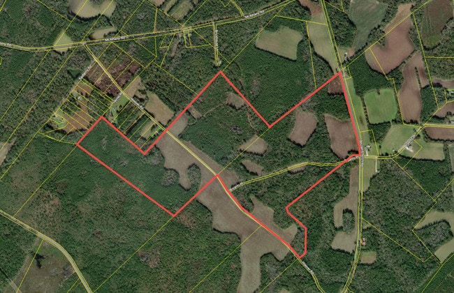
Hoover Rd
054-00-00-027
Property Of Ruby H Reeves
Vacantlandnec
TRACT 6A&6B
X
Dorchester
45029C0065G
South Carolina
2025
97.41 AC
2025
Dorchester County
011701
Charleston/N Charleston
980 SF
Charleston-North Charleston, SC
DEMOGRAPHICS near Hoover Rd
1 Mile
3 Mile
5 Mile
2024 Total Population
40
368
1,743
2029 Population
44
394
1,829
Pop Growth 2024-2029
+ 10.00%
+ 7.07%
+ 4.93%
Average Age
44
43
43
2024 Total Households
17
155
724
HH Growth 2024-2029
+ 11.76%
+ 7.10%
+ 4.83%
Median Household Inc
$34,999
$33,845
$35,950
Avg Household Size
2.30
2.40
2.40
2024 Avg HH Vehicles
2.00
2.00
2.00
Median Home Value
$166,666
$146,296
$120,800
Median Year Built
1983
1984
1985
Nearby Places
Map Layers
Map Styles
 Street
 Aerial
- Restaurants
- Banks
- Shops
- Fitness
- Groceries
SALE & LEASE HISTORY
LISTING DATE
SALE/LEASE

May 23, 2019
For Sale
Nearby Properties
Address
Land Use
TOTAL SIZE
Lot Size
Zoning
Address
Land Use
TOTAL SIZE
Lot Size
Zoning
249 AC
RD
Address
Land Use
TOTAL SIZE
Lot Size
Zoning
491 AC
RD
Address
Land Use
TOTAL SIZE
Lot Size
Zoning
254.35 AC
AR_DC
Address
Land Use
TOTAL SIZE
Lot Size
Zoning
200 AC
AR_DC
Address
Land Use
TOTAL SIZE
Lot Size
Zoning
194.69 AC
AR_DC
Address
Land Use
TOTAL SIZE
Lot Size
Zoning
194.11 AC
AR_DC
Address
Land Use
TOTAL SIZE
Lot Size
Zoning
191.55 AC
AR_DC
Address
Land Use
TOTAL SIZE
Lot Size
Zoning
164 AC
AR_DC
Address
Land Use
TOTAL SIZE
Lot Size
Zoning
160 AC
AR_DC
Address
Land Use
TOTAL SIZE
Lot Size
Zoning
93.89 AC
AR_DC
Address
Land Use
TOTAL SIZE
Lot Size
Zoning
148.98 AC
AR_DC
Address
Land Use
TOTAL SIZE
Lot Size
Zoning
139 AC
AR_DC
Address
Land Use
TOTAL SIZE
Lot Size
Zoning
137.53 AC
AR_DC
Address
Land Use
TOTAL SIZE
Lot Size
Zoning
98.43 AC
AR_DC
Address
Land Use
TOTAL SIZE
Lot Size
Zoning
97.41 AC
AR_DC
Address
Land Use
TOTAL SIZE
Lot Size
Zoning
97.42 AC
AR_DC
Address
Land Use
TOTAL SIZE
Lot Size
Zoning
97.42 AC
AR_DC
Address
Land Use
TOTAL SIZE
Lot Size
Zoning
135.42 AC
AR_DC
Address
Land Use
TOTAL SIZE
Lot Size
Zoning
16,200 SF
97.04 AC
AR_DC
Address
Land Use
TOTAL SIZE
Lot Size
Zoning
132.67 AC
AR_DC
Address
Land Use
TOTAL SIZE
Lot Size
Zoning
130.83 AC
AR_DC
Address
Land Use
TOTAL SIZE
Lot Size
Zoning
130.46 AC
AR_DC
Address
Land Use
TOTAL SIZE
Lot Size
Zoning
88.31 AC
AR_DC
Address
Land Use
TOTAL SIZE
Lot Size
Zoning
90.04 AC
AR_DC
Address
Land Use
TOTAL SIZE
Lot Size
Zoning
123.80 AC
AR_DC
Address
Land Use
TOTAL SIZE
Lot Size
Zoning
87.77 AC
AR_DC
Address
Land Use
TOTAL SIZE
Lot Size
Zoning
85.65 AC
AR_DC
Address
Land Use
TOTAL SIZE
Lot Size
Zoning
97.41 AC
AR_DC
Address
Land Use
TOTAL SIZE
Lot Size
Zoning
97.54 AC
AR_DC
The World's #1 Commercial Real Estate Marketplace
Connect with us
© 2025 CoStar Group
The information above has been obtained from sources believed reliable. While we do not doubt its accuracy we have not verified it and make no guarantee, warranty or representation about it. It is your responsibility to independently confirm its accuracy and completeness. Any projections, opinions, assumptions, or estimates used are for example only and do not represent the current or future performance of the property. The value of this transaction to you depends on tax and other factors which should be evaluated by your tax, financial, and legal advisors. You and your advisors should conduct a careful, independent investigation of the property to determine to your satisfaction the suitability of the property for your needs.