Property Record
Houcks Mill Rd, Monkton, MD 21111

Property Detail
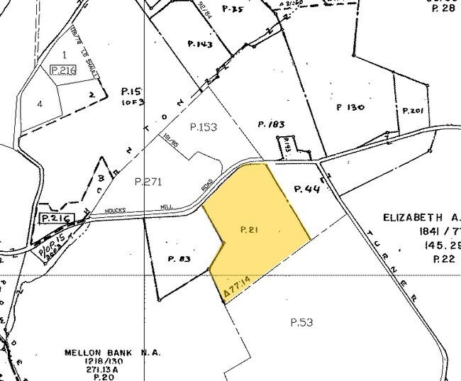
Houcks Mill Rd
04-069692
16.552 AC HOUCKS MILL ROAD LD R COLEMAN PT 77/14
Agriculturalland
HARFORD
AG
Maryland
B and X Area of moderate flood hazard, usually the area between the limits of the 100-year and 500-year floods.
16.55 AC
2025
Outlying Harford County
2025
Baltimore
410100
Baltimore-Columbia-Towson, MD
NEARBY LISTINGS FOR SALE OR LEASE
DEMOGRAPHICS near Houcks Mill Rd
1 mile
3 mile
5 mile
2025 Total Population
304
3,981
16,442
2030 Population
302
3,955
16,383
Pop Growth 2025-2030
(0.66%)
(0.65%)
(0.36%)
Average Age
46
45
44
2025 Total Households
118
1,464
5,867
HH Growth 2025-2030
(0.85%)
(0.61%)
(0.36%)
Median Household Inc
$107,812
$126,143
$134,000
Avg Household Size
2.50
2.70
2.80
2025 Avg HH Vehicles
3.00
3.00
3.00
Median Home Value
$545,454
$590,164
$586,972
Median Year Built
1977
1978
1977
Nearby Places
Map Layers
Map Styles
 Street
 Aerial
Transit
 Traffic
 Biking
Places
Listings with unknown addresses are not visible on the map
- Restaurants
- Banks
- Shops
- Fitness
- Groceries
PUBLIC TRANSPORTATION
AIRPORT
Baltimore/Washington International Thurgood Marshall
Drive
Walk
Distance
Baltimore/Washington International Thurgood Marshall
67 min
40.2 mi
Freight Ports
Port of Baltimore
Drive
Walk
Distance
Port of Baltimore
53 min
29.1 mi
Nearby Properties
Address
Land Use
TOTAL SIZE
Lot Size
Zoning
Address
Land Use
TOTAL SIZE
Lot Size
Zoning
27.43 AC
AG
Address
Land Use
TOTAL SIZE
Lot Size
Zoning
7,116 SF
7.37 AC
AG
Address
Land Use
TOTAL SIZE
Lot Size
Zoning
22,697 SF
92.32 AC
Address
Land Use
TOTAL SIZE
Lot Size
Zoning
14,036 SF
129.69 AC
Address
Land Use
TOTAL SIZE
Lot Size
Zoning
10,709 SF
90.27 AC
Address
Land Use
TOTAL SIZE
Lot Size
Zoning
10,369 SF
23.16 AC
RC2
Address
Land Use
TOTAL SIZE
Lot Size
Zoning
13,032 SF
132.04 AC
Address
Land Use
TOTAL SIZE
Lot Size
Zoning
9,380 SF
0.83 AC
B3
Address
Land Use
TOTAL SIZE
Lot Size
Zoning
7,308 SF
54.87 AC
Address
Land Use
TOTAL SIZE
Lot Size
Zoning
2,800 SF
4.34 AC
B1
Address
Land Use
TOTAL SIZE
Lot Size
Zoning
13,000 SF
2.70 AC
B3 AG
Address
Land Use
TOTAL SIZE
Lot Size
Zoning
600 SF
4.82 AC
AG
Address
Land Use
TOTAL SIZE
Lot Size
Zoning
4,703 SF
78.19 AC
Address
Land Use
TOTAL SIZE
Lot Size
Zoning
6,755 SF
10.45 AC
Address
Land Use
TOTAL SIZE
Lot Size
Zoning
6,551 SF
18 AC
Address
Land Use
TOTAL SIZE
Lot Size
Zoning
6,240 SF
16.61 AC
Address
Land Use
TOTAL SIZE
Lot Size
Zoning
7,367 SF
14.17 AC
AG
Address
Land Use
TOTAL SIZE
Lot Size
Zoning
5,252 SF
107.92 AC
Address
Land Use
TOTAL SIZE
Lot Size
Zoning
3,198 SF
60.81 AC
AG
Address
Land Use
TOTAL SIZE
Lot Size
Zoning
1,542 SF
1.61 AC
B3
Address
Land Use
TOTAL SIZE
Lot Size
Zoning
6,505 SF
10 AC
Address
Land Use
TOTAL SIZE
Lot Size
Zoning
4,354 SF
71.23 AC
Address
Land Use
TOTAL SIZE
Lot Size
Zoning
5,533 SF
21.16 AC
Address
Land Use
TOTAL SIZE
Lot Size
Zoning
6,953 SF
66.41 AC
RC2
Address
Land Use
TOTAL SIZE
Lot Size
Zoning
7,645 SF
62.50 AC
Address
Land Use
TOTAL SIZE
Lot Size
Zoning
5,648 SF
42.72 AC
Address
Land Use
TOTAL SIZE
Lot Size
Zoning
9,835 SF
14.16 AC
Address
Land Use
TOTAL SIZE
Lot Size
Zoning
5,038 SF
87.63 AC
Address
Land Use
TOTAL SIZE
Lot Size
Zoning
7.59 AC
AG
Address
Land Use
TOTAL SIZE
Lot Size
Zoning
5,981 SF
18.52 AC
The World's #1 Commercial Real Estate Marketplace
Connect with us
© 2026 CoStar Group
The information above has been obtained from sources believed reliable. While we do not doubt its accuracy we have not verified it and make no guarantee, warranty or representation about it. It is your responsibility to independently confirm its accuracy and completeness. Any projections, opinions, assumptions, or estimates used are for example only and do not represent the current or future performance of the property. The value of this transaction to you depends on tax and other factors which should be evaluated by your tax, financial, and legal advisors. You and your advisors should conduct a careful, independent investigation of the property to determine to your satisfaction the suitability of the property for your needs.