Property Record
Houston Rd, Byron, GA 31008

Save to a Folder
{{folder.Name}}
{{folder.ListingIds.length}} Properties
{{folder.ListingIds.length}} Property
Create a New Folder
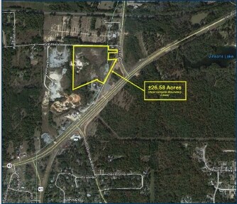
Property Detail
Houston Rd
Warner Robins, GA
TRACT 1 \ 26.30 AC LL80 LD5
065D-016
PEACH
Industrialgeneral
Georgia
M-1
1
B and X Area of moderate flood hazard, usually the area between the limits of the 100-year and 500-year floods.
26.30 AC
2025
Perry/Warner Robins
2025
Other Market Areas
040103
NEARBY LISTINGS FOR SALE OR LEASE
DEMOGRAPHICS near Houston Rd
1 mile
3 mile
5 mile
2025 Total Population
1,112
12,024
51,191
2030 Population
1,166
12,530
53,131
Pop Growth 2025-2030
+ 4.86%
+ 4.21%
+ 3.79%
Average Age
45
41
40
2025 Total Households
431
4,555
20,219
HH Growth 2025-2030
+ 4.87%
+ 4.17%
+ 3.84%
Median Household Inc
$86,986
$83,847
$70,082
Avg Household Size
2.50
2.60
2.50
2025 Avg HH Vehicles
2.00
2.00
2.00
Median Home Value
$235,185
$207,171
$197,344
Median Year Built
1992
1993
1992
Nearby Places
Map Layers
Map Styles
 Street
 Aerial
Layers
 Traffic
 Biking
Places
Listings with unknown addresses are not visible on the map
- Restaurants
- Banks
- Shops
- Fitness
- Groceries
Nearby Properties
Address
Land Use
TOTAL SIZE
Lot Size
Zoning
Address
Land Use
TOTAL SIZE
Lot Size
Zoning
275 SF
95.56 AC
M-1
Address
Land Use
TOTAL SIZE
Lot Size
Zoning
11,088 SF
59.57 AC
M-2
Address
Land Use
TOTAL SIZE
Lot Size
Zoning
10,000 SF
1,163 AC
R-AG
Address
Land Use
TOTAL SIZE
Lot Size
Zoning
5,096 SF
17.65 AC
A
Address
Land Use
TOTAL SIZE
Lot Size
Zoning
100,000 SF
32.51 AC
M-2
Address
Land Use
TOTAL SIZE
Lot Size
Zoning
52,615 SF
16.38 AC
A
Address
Land Use
TOTAL SIZE
Lot Size
Zoning
47,568 SF
1.51 AC
C-3
Address
Land Use
TOTAL SIZE
Lot Size
Zoning
11,864 SF
16.72 AC
M-1
Address
Land Use
TOTAL SIZE
Lot Size
Zoning
42,056 SF
2.14 AC
C-3
Address
Land Use
TOTAL SIZE
Lot Size
Zoning
113,895 SF
10 AC
M-1
Address
Land Use
TOTAL SIZE
Lot Size
Zoning
30,568 SF
7.44 AC
A
Address
Land Use
TOTAL SIZE
Lot Size
Zoning
22,688 SF
19.01 AC
R1
Address
Land Use
TOTAL SIZE
Lot Size
Zoning
102,163 SF
10.02 AC
M-1
Address
Land Use
TOTAL SIZE
Lot Size
Zoning
35,004 SF
1.45 AC
C-3
Address
Land Use
TOTAL SIZE
Lot Size
Zoning
336 SF
32.89 AC
PDI
Address
Land Use
TOTAL SIZE
Lot Size
Zoning
213,621 SF
21.66 AC
M-1
Address
Land Use
TOTAL SIZE
Lot Size
Zoning
152,300 SF
24.47 AC
M-1
Address
Land Use
TOTAL SIZE
Lot Size
Zoning
19,440 SF
28.87 AC
M-1
Address
Land Use
TOTAL SIZE
Lot Size
Zoning
87,597 SF
10 AC
M-1
Address
Land Use
TOTAL SIZE
Lot Size
Zoning
200,100 SF
18.73 AC
M-2
Address
Land Use
TOTAL SIZE
Lot Size
Zoning
26,131 SF
5.96 AC
C-1
Address
Land Use
TOTAL SIZE
Lot Size
Zoning
57,888 SF
1.01 AC
I-1
Address
Land Use
TOTAL SIZE
Lot Size
Zoning
104,627 SF
12.74 AC
M-1
Address
Land Use
TOTAL SIZE
Lot Size
Zoning
52,850 SF
22.73 AC
M-2
Address
Land Use
TOTAL SIZE
Lot Size
Zoning
54,175 SF
12.72 AC
C-3
Address
Land Use
TOTAL SIZE
Lot Size
Zoning
5,110 SF
2.03 AC
C-3
Address
Land Use
TOTAL SIZE
Lot Size
Zoning
199,348 SF
10.52 AC
M-1
Address
Land Use
TOTAL SIZE
Lot Size
Zoning
35,784 SF
6.23 AC
C-3
Address
Land Use
TOTAL SIZE
Lot Size
Zoning
8,378 SF
7.20 AC
PDC
Address
Land Use
TOTAL SIZE
Lot Size
Zoning
58,750 SF
7.14 AC
M-1
The World's #1 Commercial Real Estate Marketplace
Connect with us
© 2026 CoStar Group
The information above has been obtained from sources believed reliable. While we do not doubt its accuracy we have not verified it and make no guarantee, warranty or representation about it. It is your responsibility to independently confirm its accuracy and completeness. Any projections, opinions, assumptions, or estimates used are for example only and do not represent the current or future performance of the property. The value of this transaction to you depends on tax and other factors which should be evaluated by your tax, financial, and legal advisors. You and your advisors should conduct a careful, independent investigation of the property to determine to your satisfaction the suitability of the property for your needs.