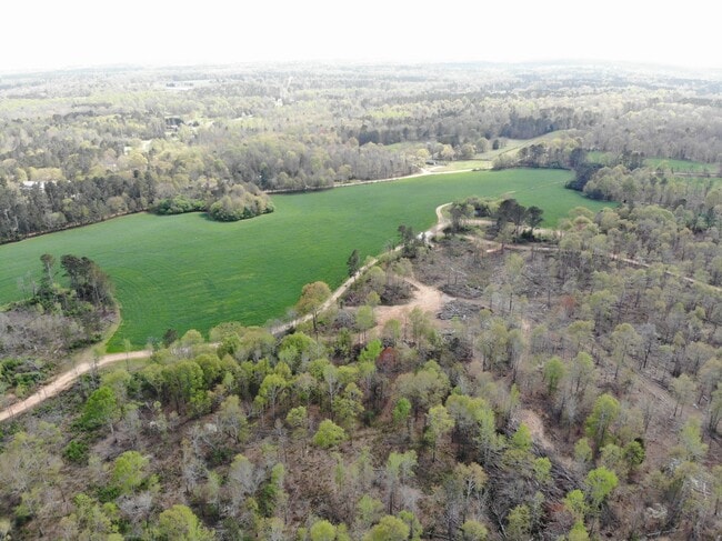
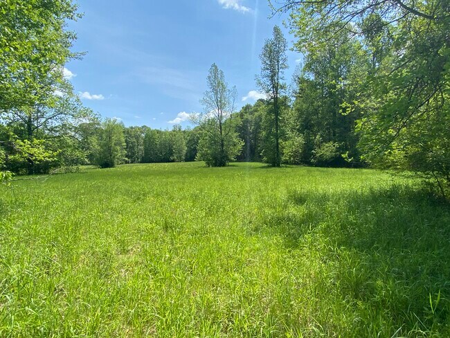
Property Record
Howard Rd, Hull, GA 30646

Property Detail
Howard Rd
0018-039
OBS/TRACTS 1 & 2
Agriculturalland
MADISON
A1
Georgia
A Areas with a 1% annual chance of flooding and a 26% chance of flooding over the life of a 30-year mortgage.
588.70 AC
2025
Athens/Gainesville
2025
Other Market Areas
020502
Athens-Clarke County, GA
NEARBY LISTINGS FOR SALE OR LEASE
DEMOGRAPHICS near Howard Rd
1 mile
3 mile
5 mile
2025 Total Population
551
10,693
22,303
2030 Population
581
11,149
23,363
Pop Growth 2025-2030
+ 5.44%
+ 4.26%
+ 4.75%
Average Age
41
39
39
2025 Total Households
214
3,834
8,365
HH Growth 2025-2030
+ 5.14%
+ 4.30%
+ 4.66%
Median Household Inc
$71,785
$57,489
$60,573
Avg Household Size
2.60
2.70
2.60
2025 Avg HH Vehicles
3.00
2.00
2.00
Median Home Value
$137,705
$199,479
$221,612
Median Year Built
1992
1992
1991
Nearby Places
Map Layers
Map Styles
 Street
 Aerial
Layers
 Traffic
 Biking
Places
Listings with unknown addresses are not visible on the map
- Restaurants
- Banks
- Shops
- Fitness
- Groceries
SALE & LEASE HISTORY
LISTING DATE
SALE/LEASE

Aug 17, 2021
For Sale
Nearby Properties
Address
Land Use
TOTAL SIZE
Lot Size
Zoning
Address
Land Use
TOTAL SIZE
Lot Size
Zoning
18.38 AC
G
Address
Land Use
TOTAL SIZE
Lot Size
Zoning
13,320 SF
60.89 AC
C-G
Address
Land Use
TOTAL SIZE
Lot Size
Zoning
42,254 SF
19.23 AC
B
Address
Land Use
TOTAL SIZE
Lot Size
Zoning
60,480 SF
13.87 AC
A1
Address
Land Use
TOTAL SIZE
Lot Size
Zoning
1 SF
17.11 AC
C-R
Address
Land Use
TOTAL SIZE
Lot Size
Zoning
372.42 AC
A2
Address
Land Use
TOTAL SIZE
Lot Size
Zoning
106.17 AC
P
Address
Land Use
TOTAL SIZE
Lot Size
Zoning
840 SF
73.31 AC
AR
Address
Land Use
TOTAL SIZE
Lot Size
Zoning
25,000 SF
18.39 AC
C-R
Address
Land Use
TOTAL SIZE
Lot Size
Zoning
27,875 SF
6.02 AC
C-R
Address
Land Use
TOTAL SIZE
Lot Size
Zoning
7,216 SF
4 AC
C-R
Address
Land Use
TOTAL SIZE
Lot Size
Zoning
108.33 AC
P
Address
Land Use
TOTAL SIZE
Lot Size
Zoning
7,000 SF
5.01 AC
G
Address
Land Use
TOTAL SIZE
Lot Size
Zoning
135.93 AC
A2
Address
Land Use
TOTAL SIZE
Lot Size
Zoning
20,000 SF
18.40 AC
B
Address
Land Use
TOTAL SIZE
Lot Size
Zoning
13,485 SF
4.30 AC
B
Address
Land Use
TOTAL SIZE
Lot Size
Zoning
4,800 SF
9.52 AC
B
Address
Land Use
TOTAL SIZE
Lot Size
Zoning
197.63 AC
004
Address
Land Use
TOTAL SIZE
Lot Size
Zoning
5,340 SF
9.58 AC
AR
Address
Land Use
TOTAL SIZE
Lot Size
Zoning
4,200 SF
4 AC
AR
Address
Land Use
TOTAL SIZE
Lot Size
Zoning
10,102 SF
2.34 AC
B
Address
Land Use
TOTAL SIZE
Lot Size
Zoning
8,400 SF
1 AC
C-N
Address
Land Use
TOTAL SIZE
Lot Size
Zoning
19,505 SF
2.60 AC
C-N
Address
Land Use
TOTAL SIZE
Lot Size
Zoning
106.38 AC
A1
Address
Land Use
TOTAL SIZE
Lot Size
Zoning
18,576 SF
4.23 AC
C-N
Address
Land Use
TOTAL SIZE
Lot Size
Zoning
10,000 SF
1.25 AC
R3
Address
Land Use
TOTAL SIZE
Lot Size
Zoning
2,450 SF
2 AC
C-R
Address
Land Use
TOTAL SIZE
Lot Size
Zoning
126.49 AC
001
Address
Land Use
TOTAL SIZE
Lot Size
Zoning
3,138 SF
1.74 AC
R1
The World's #1 Commercial Real Estate Marketplace
Connect with us
© 2026 CoStar Group
The information above has been obtained from sources believed reliable. While we do not doubt its accuracy we have not verified it and make no guarantee, warranty or representation about it. It is your responsibility to independently confirm its accuracy and completeness. Any projections, opinions, assumptions, or estimates used are for example only and do not represent the current or future performance of the property. The value of this transaction to you depends on tax and other factors which should be evaluated by your tax, financial, and legal advisors. You and your advisors should conduct a careful, independent investigation of the property to determine to your satisfaction the suitability of the property for your needs.