Property Record
Howell Rd, Duncan, SC 29334
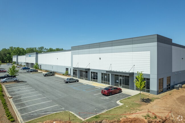

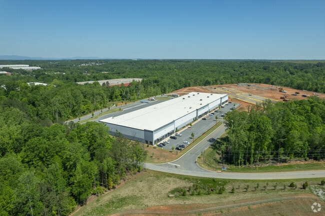
Property Detail
Howell Rd
Spartanburg, SC
PARCEL 1 EASTGROUP PROPERTIES LP SUR PB 105-219 DB 62L-264 PB 179-923 DB 133M-480 DB 133M-484 DB 133
5-26-00-013.00
SPARTANBURG
Taxexempt
South Carolina
AE The base floodplain where base flood elevations are provided. AE Zones are now used on new format FIRMs instead of A1-A30 Zones.
18.27 AC
0
Rt 290 Corridor
2025
Greenville/Spartanburg
023101
NEARBY LISTINGS FOR SALE OR LEASE
DEMOGRAPHICS near Howell Rd
1 mile
3 mile
5 mile
2025 Total Population
1,961
25,576
62,219
2030 Population
2,171
28,522
69,730
Pop Growth 2025-2030
+ 10.71%
+ 11.52%
+ 12.07%
Average Age
36
38
39
2025 Total Households
804
9,620
23,427
HH Growth 2025-2030
+ 10.82%
+ 11.53%
+ 12.09%
Median Household Inc
$64,091
$73,719
$74,312
Avg Household Size
2.40
2.60
2.60
2025 Avg HH Vehicles
2.00
2.00
2.00
Median Home Value
$178,204
$269,319
$275,368
Median Year Built
1996
2001
1999
Nearby Places
Map Layers
Map Styles
 Street
 Aerial
Transit
 Traffic
 Biking
Places
Listings with unknown addresses are not visible on the map
- Restaurants
- Banks
- Shops
- Fitness
- Groceries
PUBLIC TRANSPORTATION
AIRPORT
Greenville Spartanburg International
Drive
Walk
Distance
Greenville Spartanburg International
18 min
9.6 mi
Freight Ports
North Charleston Terminal
Drive
Walk
Distance
North Charleston Terminal
223 min
195.8 mi
SALE & LEASE HISTORY
LISTING DATE
SALE/LEASE

Oct 27, 2021
For Lease
Nearby Properties
Address
Land Use
TOTAL SIZE
Lot Size
Zoning
Address
Land Use
TOTAL SIZE
Lot Size
Zoning
873,910 SF
31.46 AC
Address
Land Use
TOTAL SIZE
Lot Size
Zoning
318,450 SF
22.63 AC
Address
Land Use
TOTAL SIZE
Lot Size
Zoning
303,442 SF
21.23 AC
Address
Land Use
TOTAL SIZE
Lot Size
Zoning
185,745 SF
14.17 AC
Address
Land Use
TOTAL SIZE
Lot Size
Zoning
61,536 SF
16.16 AC
Address
Land Use
TOTAL SIZE
Lot Size
Zoning
2,528 SF
14.74 AC
Address
Land Use
TOTAL SIZE
Lot Size
Zoning
417,082 SF
10 AC
Address
Land Use
TOTAL SIZE
Lot Size
Zoning
286,000 SF
29.26 AC
Address
Land Use
TOTAL SIZE
Lot Size
Zoning
14,168 SF
8.33 AC
Address
Land Use
TOTAL SIZE
Lot Size
Zoning
27,288 SF
19.85 AC
Address
Land Use
TOTAL SIZE
Lot Size
Zoning
2,417 SF
21.12 AC
Address
Land Use
TOTAL SIZE
Lot Size
Zoning
26,472 SF
3.90 AC
Address
Land Use
TOTAL SIZE
Lot Size
Zoning
29.56 AC
Address
Land Use
TOTAL SIZE
Lot Size
Zoning
35,068 SF
41.56 AC
Address
Land Use
TOTAL SIZE
Lot Size
Zoning
1,964,569 SF
46.64 AC
Address
Land Use
TOTAL SIZE
Lot Size
Zoning
33.40 AC
Address
Land Use
TOTAL SIZE
Lot Size
Zoning
1,798 SF
9.63 AC
Address
Land Use
TOTAL SIZE
Lot Size
Zoning
15,300 SF
13.48 AC
Address
Land Use
TOTAL SIZE
Lot Size
Zoning
38,313 SF
15.53 AC
Address
Land Use
TOTAL SIZE
Lot Size
Zoning
2,740 SF
20.62 AC
Address
Land Use
TOTAL SIZE
Lot Size
Zoning
67,938 SF
8.02 AC
Address
Land Use
TOTAL SIZE
Lot Size
Zoning
Address
Land Use
TOTAL SIZE
Lot Size
Zoning
60,668 SF
8.02 AC
Address
Land Use
TOTAL SIZE
Lot Size
Zoning
32,310 SF
13.72 AC
Address
Land Use
TOTAL SIZE
Lot Size
Zoning
10,126 SF
11.86 AC
Address
Land Use
TOTAL SIZE
Lot Size
Zoning
107.32 AC
Address
Land Use
TOTAL SIZE
Lot Size
Zoning
851,634 SF
15.69 AC
Address
Land Use
TOTAL SIZE
Lot Size
Zoning
111,000 SF
14.36 AC
Address
Land Use
TOTAL SIZE
Lot Size
Zoning
10,756 SF
3.42 AC
The World's #1 Commercial Real Estate Marketplace
Connect with us
© 2026 CoStar Group
The information above has been obtained from sources believed reliable. While we do not doubt its accuracy we have not verified it and make no guarantee, warranty or representation about it. It is your responsibility to independently confirm its accuracy and completeness. Any projections, opinions, assumptions, or estimates used are for example only and do not represent the current or future performance of the property. The value of this transaction to you depends on tax and other factors which should be evaluated by your tax, financial, and legal advisors. You and your advisors should conduct a careful, independent investigation of the property to determine to your satisfaction the suitability of the property for your needs.