Property Record
Howland Blvd, Deltona, FL 32725

This Property Is For Sale
Property Detail
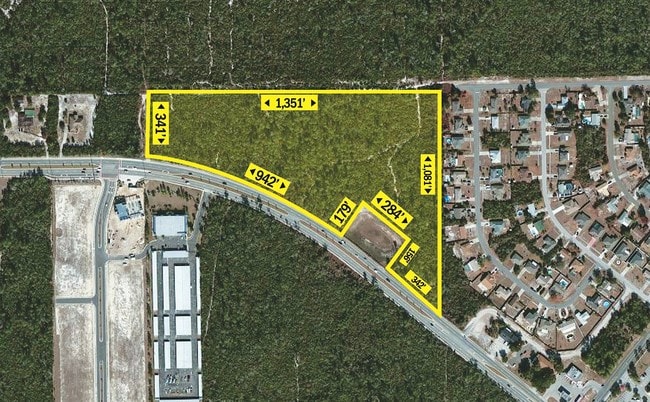
Howland Blvd
8109-00-00-0062
9-18-31 W 1/4 LYING N OF HOWLAND BLVD EXC IRREG PARCEL FOR DRAINAGE RETENTION POND MEAS 276 FT ON N/L & 172.41 FT ON W/L PER OR 4496 PG 0484
Commercialacreage
VOLUSIA
01B
Florida
A Areas with a 1% annual chance of flooding and a 26% chance of flooding over the life of a 30-year mortgage.
17.58 AC
2025
Deltona
2026
Deltona/Daytona Beach
091016
Deltona-Daytona Beach-Ormond Beach, FL
NEARBY LISTINGS FOR SALE OR LEASE
DEMOGRAPHICS near Howland Blvd
1 mile
3 mile
5 mile
2025 Total Population
3,965
42,195
115,644
2030 Population
4,208
44,726
122,859
Pop Growth 2025-2030
+ 6.13%
+ 6.00%
+ 6.24%
Average Age
41
41
42
2025 Total Households
1,350
15,057
42,978
HH Growth 2025-2030
+ 6.07%
+ 5.88%
+ 6.21%
Median Household Inc
$74,770
$78,113
$74,026
Avg Household Size
2.80
2.70
2.60
2025 Avg HH Vehicles
2.00
2.00
2.00
Median Home Value
$315,346
$316,726
$317,339
Median Year Built
1991
1989
1989
Nearby Places
Map Layers
Map Styles
 Street
 Aerial
Layers
 Traffic
 Biking
Places
Listings with unknown addresses are not visible on the map
- Restaurants
- Banks
- Shops
- Fitness
- Groceries
PUBLIC TRANSPORTATION
AIRPORT
Orlando Sanford International
Drive
Walk
Distance
Orlando Sanford International
31 min
19.7 mi
Daytona Beach International
Drive
Walk
Distance
Daytona Beach International
30 min
23.2 mi
Freight Ports
Port Canaveral
Drive
Walk
Distance
Port Canaveral
93 min
78.3 mi
Nearby Properties
Address
Land Use
TOTAL SIZE
Lot Size
Zoning
Address
Land Use
TOTAL SIZE
Lot Size
Zoning
986,415 SF
56.11 AC
Address
Land Use
TOTAL SIZE
Lot Size
Zoning
1,337,979 SF
85.14 AC
01I2
Address
Land Use
TOTAL SIZE
Lot Size
Zoning
613,629 SF
630 AC
P
Address
Land Use
TOTAL SIZE
Lot Size
Zoning
204,239 SF
31.36 AC
Address
Land Use
TOTAL SIZE
Lot Size
Zoning
423,073 SF
12.48 AC
Address
Land Use
TOTAL SIZE
Lot Size
Zoning
352,859 SF
16 AC
R4C2
Address
Land Use
TOTAL SIZE
Lot Size
Zoning
339,508 SF
72.75 AC
01A3
Address
Land Use
TOTAL SIZE
Lot Size
Zoning
254,255 SF
28.64 AC
Address
Land Use
TOTAL SIZE
Lot Size
Zoning
33,371 SF
12.86 AC
Address
Land Use
TOTAL SIZE
Lot Size
Zoning
5,195 SF
55.08 AC
A3
Address
Land Use
TOTAL SIZE
Lot Size
Zoning
123,193 SF
20 AC
01A3
Address
Land Use
TOTAL SIZE
Lot Size
Zoning
9,421 SF
7 AC
Address
Land Use
TOTAL SIZE
Lot Size
Zoning
7,318 SF
1.90 AC
Address
Land Use
TOTAL SIZE
Lot Size
Zoning
100,345 SF
19.70 AC
Address
Land Use
TOTAL SIZE
Lot Size
Zoning
28.62 AC
01A1
Address
Land Use
TOTAL SIZE
Lot Size
Zoning
57,885 SF
4.45 AC
Address
Land Use
TOTAL SIZE
Lot Size
Zoning
43,178 SF
4.23 AC
C1
Address
Land Use
TOTAL SIZE
Lot Size
Zoning
54,784 SF
0.84 AC
Address
Land Use
TOTAL SIZE
Lot Size
Zoning
139,919 SF
7.20 AC
MPUD
Address
Land Use
TOTAL SIZE
Lot Size
Zoning
98,015 SF
14 AC
01R
Address
Land Use
TOTAL SIZE
Lot Size
Zoning
46.31 AC
A32
Address
Land Use
TOTAL SIZE
Lot Size
Zoning
28,908 SF
0.67 AC
Address
Land Use
TOTAL SIZE
Lot Size
Zoning
5,279 SF
38.30 AC
RR
Address
Land Use
TOTAL SIZE
Lot Size
Zoning
65.94 AC
Address
Land Use
TOTAL SIZE
Lot Size
Zoning
44,667 SF
4.56 AC
01A3
Address
Land Use
TOTAL SIZE
Lot Size
Zoning
66,221 SF
10.48 AC
C2
Address
Land Use
TOTAL SIZE
Lot Size
Zoning
41.03 AC
01I1
Address
Land Use
TOTAL SIZE
Lot Size
Zoning
83,829 SF
9.46 AC
Address
Land Use
TOTAL SIZE
Lot Size
Zoning
Address
Land Use
TOTAL SIZE
Lot Size
Zoning
18,262 SF
4.05 AC
01A3
The World's #1 Commercial Real Estate Marketplace
Connect with us
© 2026 CoStar Group
The information above has been obtained from sources believed reliable. While we do not doubt its accuracy we have not verified it and make no guarantee, warranty or representation about it. It is your responsibility to independently confirm its accuracy and completeness. Any projections, opinions, assumptions, or estimates used are for example only and do not represent the current or future performance of the property. The value of this transaction to you depends on tax and other factors which should be evaluated by your tax, financial, and legal advisors. You and your advisors should conduct a careful, independent investigation of the property to determine to your satisfaction the suitability of the property for your needs.