Property Record
Hr Ranch Rd, , WY


NEARBY LISTINGS FOR SALE OR LEASE
-
-
View all listings for lease on LoopNet.com
Property Detail
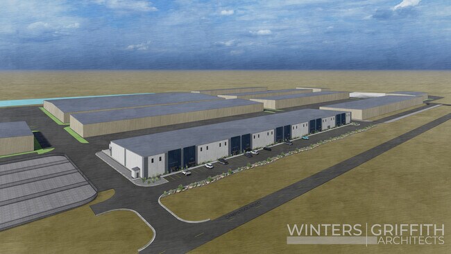
Hr Ranch Rd
Cheyenne, WY
Plains Industrial Park, 3Rd Filing
1-7127-0001-0002-0
PLAINS INDUSTRIAL PARK, 3RD FILING: LOT 2, BLOCK 1
Industrialacreage
Laramie
AE
Wyoming
56021C1114F
2
2024
13.60 AC
2025
I-80 Corridor/Cheyenne
000402
Other Market Areas
DEMOGRAPHICS near Hr Ranch Rd
1 Mile
3 Mile
5 Mile
2024 Total Population
50
13,743
41,554
2029 Population
51
14,024
42,384
Pop Growth 2024-2029
+ 2.00%
+ 2.04%
+ 2.00%
Average Age
40
37
39
2024 Total Households
18
5,279
16,992
HH Growth 2024-2029
0.00%
+ 2.12%
+ 2.11%
Median Household Inc
$81,250
$77,253
$64,875
Avg Household Size
2.70
2.60
2.40
2024 Avg HH Vehicles
2.00
2.00
2.00
Median Home Value
$440,000
$308,465
$271,201
Median Year Built
2010
1994
1982
Nearby Places
Map Layers
Map Styles
 Street
 Aerial
- Restaurants
- Banks
- Shops
- Fitness
- Groceries
SALE & LEASE HISTORY
LISTING DATE
SALE/LEASE

Mar 06, 2024
For Lease
Nearby Properties
Address
Land Use
TOTAL SIZE
Lot Size
Zoning
Address
Land Use
TOTAL SIZE
Lot Size
Zoning
1,120,931 SF
149.20 AC
Address
Land Use
TOTAL SIZE
Lot Size
Zoning
639,397 SF
67.52 AC
Address
Land Use
TOTAL SIZE
Lot Size
Zoning
243,960 SF
60.52 AC
Address
Land Use
TOTAL SIZE
Lot Size
Zoning
156,244 SF
4.75 AC
Address
Land Use
TOTAL SIZE
Lot Size
Zoning
180,600 SF
13.72 AC
HI
Address
Land Use
TOTAL SIZE
Lot Size
Zoning
114,342 SF
59.95 AC
HI
Address
Land Use
TOTAL SIZE
Lot Size
Zoning
109,096 SF
4.03 AC
MR2
Address
Land Use
TOTAL SIZE
Lot Size
Zoning
37,714 SF
4.29 AC
Address
Land Use
TOTAL SIZE
Lot Size
Zoning
96,088 SF
8.34 AC
Address
Land Use
TOTAL SIZE
Lot Size
Zoning
59,223 SF
9.91 AC
HI
Address
Land Use
TOTAL SIZE
Lot Size
Zoning
65,520 SF
8.20 AC
Address
Land Use
TOTAL SIZE
Lot Size
Zoning
135,125 SF
8.87 AC
Address
Land Use
TOTAL SIZE
Lot Size
Zoning
174,000 SF
11.57 AC
MR2
Address
Land Use
TOTAL SIZE
Lot Size
Zoning
82,494 SF
17.27 AC
Address
Land Use
TOTAL SIZE
Lot Size
Zoning
46,705 SF
14.11 AC
HI
Address
Land Use
TOTAL SIZE
Lot Size
Zoning
33,080 SF
8.91 AC
Address
Land Use
TOTAL SIZE
Lot Size
Zoning
131,194 SF
17.67 AC
MR2
Address
Land Use
TOTAL SIZE
Lot Size
Zoning
114,503 SF
11.43 AC
MR2
Address
Land Use
TOTAL SIZE
Lot Size
Zoning
137,934 SF
15.52 AC
HI
Address
Land Use
TOTAL SIZE
Lot Size
Zoning
104,870 SF
6.44 AC
Address
Land Use
TOTAL SIZE
Lot Size
Zoning
66,102 SF
4.96 AC
HR1
Address
Land Use
TOTAL SIZE
Lot Size
Zoning
67,728 SF
34.57 AC
HI
Address
Land Use
TOTAL SIZE
Lot Size
Zoning
23,926 SF
2.21 AC
CB
Address
Land Use
TOTAL SIZE
Lot Size
Zoning
23,232 SF
1.76 AC
MR2
Address
Land Use
TOTAL SIZE
Lot Size
Zoning
50,585 SF
5.83 AC
HI
Address
Land Use
TOTAL SIZE
Lot Size
Zoning
40,173 SF
9.86 AC
HI
Address
Land Use
TOTAL SIZE
Lot Size
Zoning
37,188 SF
2.89 AC
CB
Address
Land Use
TOTAL SIZE
Lot Size
Zoning
39,626 SF
9.16 AC
Address
Land Use
TOTAL SIZE
Lot Size
Zoning
44,075 SF
13.46 AC
LI
Address
Land Use
TOTAL SIZE
Lot Size
Zoning
33,856 SF
12.40 AC
HI
The World's #1 Commercial Real Estate Marketplace
Connect with us
© 2026 CoStar Group
The information above has been obtained from sources believed reliable. While we do not doubt its accuracy we have not verified it and make no guarantee, warranty or representation about it. It is your responsibility to independently confirm its accuracy and completeness. Any projections, opinions, assumptions, or estimates used are for example only and do not represent the current or future performance of the property. The value of this transaction to you depends on tax and other factors which should be evaluated by your tax, financial, and legal advisors. You and your advisors should conduct a careful, independent investigation of the property to determine to your satisfaction the suitability of the property for your needs.