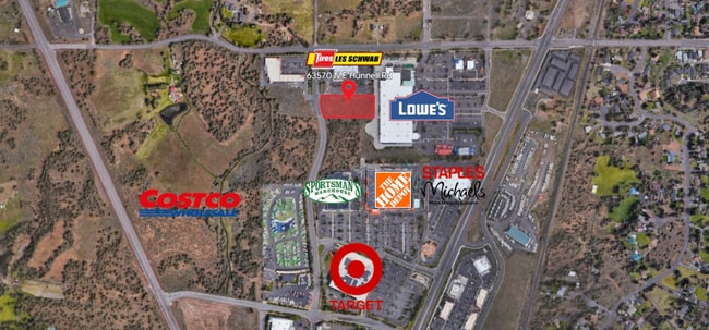
Property Record
63550 Hunnell Rd, Bend, OR 97703


NEARBY LISTINGS FOR SALE OR LEASE
Property Detail
63550 Hunnell Rd
Bend, OR
Pp2007-14
256954
PP2007-14 LOT PARCEL 3
Commercialacreage
Deschutes
X
Oregon
41017C0660E
3
2025
2.30 AC
2025
Deschutes County
001102
Portland
DEMOGRAPHICS near 63550 Hunnell Rd
1 Mile
3 Mile
5 Mile
2024 Total Population
4,344
33,025
81,567
2029 Population
4,814
36,712
90,959
Pop Growth 2024-2029
+ 10.82%
+ 11.16%
+ 11.51%
Average Age
40
40
41
2024 Total Households
1,561
13,044
33,908
HH Growth 2024-2029
+ 10.95%
+ 11.28%
+ 11.63%
Median Household Inc
$96,523
$93,860
$86,621
Avg Household Size
2.60
2.50
2.30
2024 Avg HH Vehicles
3.00
2.00
2.00
Median Home Value
$574,875
$632,403
$655,980
Median Year Built
2002
1998
1998
Nearby Places
Map Layers
Map Styles
 Street
 Aerial
- Restaurants
- Banks
- Shops
- Fitness
- Groceries
PUBLIC TRANSPORTATION
AIRPORT
Roberts Field
DRIVE
WALK
Distance
Roberts Field
18 min
13.4 mi
Freight Ports
Port of Portland
DRIVE
WALK
Distance
Port of Portland
227 min
174.7 mi
SALE & LEASE HISTORY
LISTING DATE
SALE/LEASE

Aug 09, 2023
For Sale
Nearby Properties
Address
Land Use
TOTAL SIZE
Lot Size
Zoning
Address
Land Use
TOTAL SIZE
Lot Size
Zoning
12,000 SF
2.77 AC
IL
Address
Land Use
TOTAL SIZE
Lot Size
Zoning
2.77 AC
IL
Address
Land Use
TOTAL SIZE
Lot Size
Zoning
7.99 AC
IL
Address
Land Use
TOTAL SIZE
Lot Size
Zoning
7.99 AC
IL
Address
Land Use
TOTAL SIZE
Lot Size
Zoning
317,867 SF
32.72 AC
CG
Address
Land Use
TOTAL SIZE
Lot Size
Zoning
1,546 SF
6.41 AC
RH
Address
Land Use
TOTAL SIZE
Lot Size
Zoning
229,286 SF
17.96 AC
CG
Address
Land Use
TOTAL SIZE
Lot Size
Zoning
70,294 SF
17.96 AC
CG
Address
Land Use
TOTAL SIZE
Lot Size
Zoning
24.36 AC
IG
Address
Land Use
TOTAL SIZE
Lot Size
Zoning
24.36 AC
IG
Address
Land Use
TOTAL SIZE
Lot Size
Zoning
24.36 AC
Address
Land Use
TOTAL SIZE
Lot Size
Zoning
171,588 SF
4.94 AC
PO
Address
Land Use
TOTAL SIZE
Lot Size
Zoning
12.04 AC
IL
Address
Land Use
TOTAL SIZE
Lot Size
Zoning
120,306 SF
12.04 AC
IL
Address
Land Use
TOTAL SIZE
Lot Size
Zoning
134,322 SF
13.62 AC
CG
Address
Land Use
TOTAL SIZE
Lot Size
Zoning
4.59 AC
RM
Address
Land Use
TOTAL SIZE
Lot Size
Zoning
179,148 SF
17.14 AC
Address
Land Use
TOTAL SIZE
Lot Size
Zoning
96,202 SF
4.28 AC
RM
Address
Land Use
TOTAL SIZE
Lot Size
Zoning
3.67 AC
IL
Address
Land Use
TOTAL SIZE
Lot Size
Zoning
3.67 AC
IL
Address
Land Use
TOTAL SIZE
Lot Size
Zoning
6.92 AC
Address
Land Use
TOTAL SIZE
Lot Size
Zoning
26,752 SF
6.92 AC
IL
Address
Land Use
TOTAL SIZE
Lot Size
Zoning
13,376 SF
6.92 AC
Address
Land Use
TOTAL SIZE
Lot Size
Zoning
70,294 SF
6 AC
CG
Address
Land Use
TOTAL SIZE
Lot Size
Zoning
95,815 SF
8.66 AC
CG
Address
Land Use
TOTAL SIZE
Lot Size
Zoning
17,948 SF
7.52 AC
CL
Address
Land Use
TOTAL SIZE
Lot Size
Zoning
80,300 SF
8.76 AC
IL
Address
Land Use
TOTAL SIZE
Lot Size
Zoning
43,915 SF
8.76 AC
IL
Address
Land Use
TOTAL SIZE
Lot Size
Zoning
94,548 SF
5.22 AC
CL
The World's #1 Commercial Real Estate Marketplace
Connect with us
© 2026 CoStar Group
The information above has been obtained from sources believed reliable. While we do not doubt its accuracy we have not verified it and make no guarantee, warranty or representation about it. It is your responsibility to independently confirm its accuracy and completeness. Any projections, opinions, assumptions, or estimates used are for example only and do not represent the current or future performance of the property. The value of this transaction to you depends on tax and other factors which should be evaluated by your tax, financial, and legal advisors. You and your advisors should conduct a careful, independent investigation of the property to determine to your satisfaction the suitability of the property for your needs.