Property Record
Hunt Rd, La Plata, MD 20646
This Property Is For Sale
NEARBY LISTINGS FOR SALE OR LEASE
-
-
View all La Plata listings for sale on LoopNet.com
Property Detail
Hunt Rd
Washington, DC
Town Of La Plata
Washington-Arlington-Alexandria, DC-VA-MD-WV
Charles
02-010763
Maryland
Residentialnec
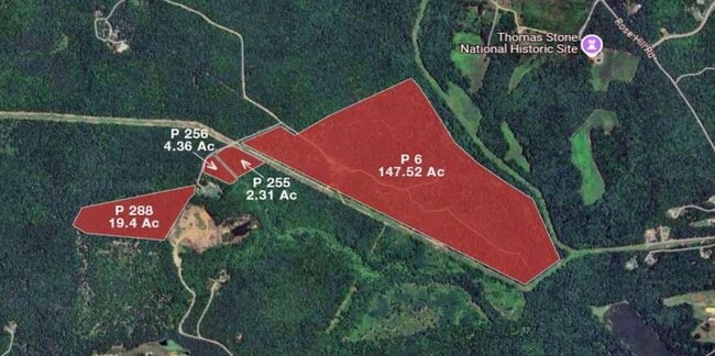
4.36 AC
X
Charles County
24017C0170D
DEMOGRAPHICS near Hunt Rd
1 Mile
3 Mile
5 Mile
2024 Total Population
228
6,742
20,277
2029 Population
235
7,063
21,267
Pop Growth 2024-2029
+ 3.07%
+ 4.76%
+ 4.88%
Average Age
43
44
42
2024 Total Households
77
2,436
7,410
HH Growth 2024-2029
+ 2.60%
+ 5.05%
+ 5.14%
Median Household Inc
$152,941
$119,647
$108,746
Avg Household Size
2.80
2.60
2.70
2024 Avg HH Vehicles
3.00
2.00
2.00
Median Home Value
$568,750
$473,083
$426,657
Median Year Built
1985
1990
1990
Nearby Places
- Restaurants
- Banks
- Shops
- Fitness
- Groceries
PUBLIC TRANSPORTATION
AIRPORT
Ronald Reagan Washington Ntl
DRIVE
WALK
Distance
Ronald Reagan Washington Ntl
63 min
32.1 mi
Freight Ports
Port of Baltimore
DRIVE
WALK
Distance
Port of Baltimore
105 min
67.7 mi
Nearby Properties
Address
Land Use
TOTAL SIZE
Lot Size
Zoning
Address
Land Use
TOTAL SIZE
Lot Size
Zoning
174,315 SF
90 AC
RC
Address
Land Use
TOTAL SIZE
Lot Size
Zoning
31,194 SF
6.05 AC
RC
Address
Land Use
TOTAL SIZE
Lot Size
Zoning
27,909 SF
10 AC
RC
Address
Land Use
TOTAL SIZE
Lot Size
Zoning
40.53 AC
WCD
Address
Land Use
TOTAL SIZE
Lot Size
Zoning
198.71 AC
RC
Address
Land Use
TOTAL SIZE
Lot Size
Zoning
7,552 SF
91.09 AC
RR
Address
Land Use
TOTAL SIZE
Lot Size
Zoning
7,936 SF
4.10 AC
CN
Address
Land Use
TOTAL SIZE
Lot Size
Zoning
321.97 AC
RC
Address
Land Use
TOTAL SIZE
Lot Size
Zoning
1,683 SF
313.24 AC
WCD
Address
Land Use
TOTAL SIZE
Lot Size
Zoning
7,200 SF
5.07 AC
AC
Address
Land Use
TOTAL SIZE
Lot Size
Zoning
7,788 SF
2 AC
RC
Address
Land Use
TOTAL SIZE
Lot Size
Zoning
8,093 SF
1 AC
AC
Address
Land Use
TOTAL SIZE
Lot Size
Zoning
8,684 SF
2.23 AC
RC
Address
Land Use
TOTAL SIZE
Lot Size
Zoning
14,666 SF
4.88 AC
CV
Address
Land Use
TOTAL SIZE
Lot Size
Zoning
7,724 SF
7.22 AC
RC
Address
Land Use
TOTAL SIZE
Lot Size
Zoning
3,412 SF
2.69 AC
CV
Address
Land Use
TOTAL SIZE
Lot Size
Zoning
7,661 SF
2.13 AC
RC
Address
Land Use
TOTAL SIZE
Lot Size
Zoning
6,769 SF
4.69 AC
RC
Address
Land Use
TOTAL SIZE
Lot Size
Zoning
14,112 SF
2.57 AC
WCD
Address
Land Use
TOTAL SIZE
Lot Size
Zoning
6,425 SF
0.97 AC
RC
Address
Land Use
TOTAL SIZE
Lot Size
Zoning
6,593 SF
1.01 AC
AC
Address
Land Use
TOTAL SIZE
Lot Size
Zoning
3,454 SF
93.35 AC
WCD
Address
Land Use
TOTAL SIZE
Lot Size
Zoning
6,084 SF
19.33 AC
RC
Address
Land Use
TOTAL SIZE
Lot Size
Zoning
161.53 AC
WCD
Address
Land Use
TOTAL SIZE
Lot Size
Zoning
6,006 SF
1.87 AC
RC
Address
Land Use
TOTAL SIZE
Lot Size
Zoning
6,180 SF
2.70 AC
RC
Address
Land Use
TOTAL SIZE
Lot Size
Zoning
5,271 SF
2.88 AC
CN
Address
Land Use
TOTAL SIZE
Lot Size
Zoning
5,018 SF
1.02 AC
AC
Address
Land Use
TOTAL SIZE
Lot Size
Zoning
5,198 SF
1.02 AC
AC
Address
Land Use
TOTAL SIZE
Lot Size
Zoning
4,921 SF
3.88 AC
RC
The World's #1 Commercial Real Estate Marketplace
Connect with us
© 2025 CoStar Group
The information above has been obtained from sources believed reliable. While we do not doubt its accuracy we have not verified it and make no guarantee, warranty or representation about it. It is your responsibility to independently confirm its accuracy and completeness. Any projections, opinions, assumptions, or estimates used are for example only and do not represent the current or future performance of the property. The value of this transaction to you depends on tax and other factors which should be evaluated by your tax, financial, and legal advisors. You and your advisors should conduct a careful, independent investigation of the property to determine to your satisfaction the suitability of the property for your needs.