Property Record
Hurricane Ln, Fresno, TX 77545
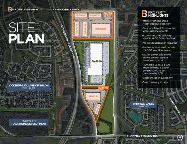
This Property Is For Sale
Property Detail
Hurricane Ln
Houston-Pasadena-The Woodlands, TX
0077 E ROARK, BLOCK 9 (PT), ACRES 0.1633, (PART OF A 98.976 ACRE TRACT)
0077-00-000-0612-907
FORT BEND
Taxexempt
Texas
B and X Area of moderate flood hazard, usually the area between the limits of the 100-year and 500-year floods.
20.59 AC
2024
E Fort Bend Co/Sugar Land
2025
Houston
670904
NEARBY LISTINGS FOR SALE OR LEASE
-
-
-
-
NWC Fort Bend Parkway Toll Road and Lake Olympia P
Missouri City, TX 77459
Rent Upon Request
21 AC Lots
Land
-
-
-
-
View all Fresno listings for sale on LoopNet.com
DEMOGRAPHICS near Hurricane Ln
1 mile
3 mile
5 mile
2025 Total Population
10,077
64,922
224,813
2030 Population
11,495
73,931
253,432
Pop Growth 2025-2030
+ 14.07%
+ 13.88%
+ 12.73%
Average Age
36
39
38
2025 Total Households
3,129
21,475
71,473
HH Growth 2025-2030
+ 14.45%
+ 14.29%
+ 13.14%
Median Household Inc
$119,261
$93,613
$97,497
Avg Household Size
3.20
3.00
3.10
2025 Avg HH Vehicles
2.00
2.00
2.00
Median Home Value
$329,772
$308,297
$324,423
Median Year Built
2010
2004
2003
Nearby Places
Map Layers
Map Styles
 Street
 Aerial
Layers
 Traffic
 Biking
Places
Listings with unknown addresses are not visible on the map
- Restaurants
- Banks
- Shops
- Fitness
- Groceries
PUBLIC TRANSPORTATION
AIRPORT
William P Hobby
Drive
Walk
Distance
William P Hobby
36 min
21.7 mi
Freight Ports
Port of Houston
Drive
Walk
Distance
Port of Houston
39 min
25.3 mi
Nearby Properties
Address
Land Use
TOTAL SIZE
Lot Size
Zoning
Address
Land Use
TOTAL SIZE
Lot Size
Zoning
81.01 AC
Address
Land Use
TOTAL SIZE
Lot Size
Zoning
344,620 SF
78.14 AC
SY
Address
Land Use
TOTAL SIZE
Lot Size
Zoning
0.08 AC
Address
Land Use
TOTAL SIZE
Lot Size
Zoning
Address
Land Use
TOTAL SIZE
Lot Size
Zoning
1,764 SF
39.64 AC
ST
Address
Land Use
TOTAL SIZE
Lot Size
Zoning
26.14 AC
Address
Land Use
TOTAL SIZE
Lot Size
Zoning
Address
Land Use
TOTAL SIZE
Lot Size
Zoning
14.35 AC
Address
Land Use
TOTAL SIZE
Lot Size
Zoning
15.86 AC
Address
Land Use
TOTAL SIZE
Lot Size
Zoning
164,540 SF
14.16 AC
Address
Land Use
TOTAL SIZE
Lot Size
Zoning
214,195 SF
12.21 AC
Address
Land Use
TOTAL SIZE
Lot Size
Zoning
12.22 AC
OS
Address
Land Use
TOTAL SIZE
Lot Size
Zoning
22,240 SF
3.98 AC
Address
Land Use
TOTAL SIZE
Lot Size
Zoning
124,342 SF
15.55 AC
Address
Land Use
TOTAL SIZE
Lot Size
Zoning
Address
Land Use
TOTAL SIZE
Lot Size
Zoning
Address
Land Use
TOTAL SIZE
Lot Size
Zoning
95,479 SF
10.17 AC
Address
Land Use
TOTAL SIZE
Lot Size
Zoning
152,721 SF
18.14 AC
Address
Land Use
TOTAL SIZE
Lot Size
Zoning
82,400 SF
10.85 AC
I
Address
Land Use
TOTAL SIZE
Lot Size
Zoning
96,295 SF
12.04 AC
I
Address
Land Use
TOTAL SIZE
Lot Size
Zoning
85,092 SF
12.95 AC
Address
Land Use
TOTAL SIZE
Lot Size
Zoning
105,790 SF
12.82 AC
X
Address
Land Use
TOTAL SIZE
Lot Size
Zoning
7.46 AC
S
Address
Land Use
TOTAL SIZE
Lot Size
Zoning
Address
Land Use
TOTAL SIZE
Lot Size
Zoning
44,427 SF
4.36 AC
Address
Land Use
TOTAL SIZE
Lot Size
Zoning
78,375 SF
6.95 AC
Address
Land Use
TOTAL SIZE
Lot Size
Zoning
132,938 SF
29 AC
MZY
Address
Land Use
TOTAL SIZE
Lot Size
Zoning
45,000 SF
11.75 AC
I
Address
Land Use
TOTAL SIZE
Lot Size
Zoning
60,386 SF
7.79 AC
Address
Land Use
TOTAL SIZE
Lot Size
Zoning
15.31 AC
The World's #1 Commercial Real Estate Marketplace
Connect with us
© 2026 CoStar Group
The information above has been obtained from sources believed reliable. While we do not doubt its accuracy we have not verified it and make no guarantee, warranty or representation about it. It is your responsibility to independently confirm its accuracy and completeness. Any projections, opinions, assumptions, or estimates used are for example only and do not represent the current or future performance of the property. The value of this transaction to you depends on tax and other factors which should be evaluated by your tax, financial, and legal advisors. You and your advisors should conduct a careful, independent investigation of the property to determine to your satisfaction the suitability of the property for your needs.