Property Record
Flowers Rd Ne, Pike Road, AL 36064
Property Detail
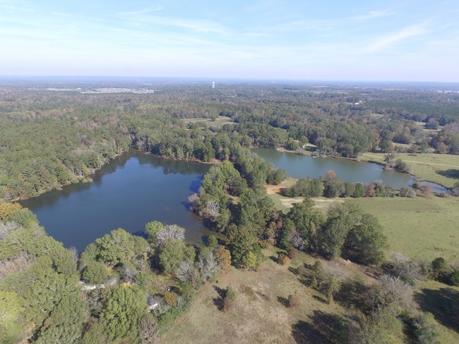
Flowers Rd Ne
Montgomery, AL
11.5 AC IN N 1/2 SEC 28 T16N R20E 0808280000002002
08-08-28-0-000-002.002
MONTGOMERY
Commercialacreage
Alabama
B and X Area of moderate flood hazard, usually the area between the limits of the 100-year and 500-year floods.
11.50 AC
2025
Outlying Montgomery Cnty
2025
Montgomery
005604
NEARBY LISTINGS FOR SALE OR LEASE
DEMOGRAPHICS near Flowers Rd Ne
1 mile
3 mile
5 mile
2025 Total Population
969
11,233
22,357
2030 Population
967
11,264
22,322
Pop Growth 2025-2030
(0.21%)
+ 0.28%
(0.16%)
Average Age
35
37
38
2025 Total Households
338
3,942
7,458
HH Growth 2025-2030
(0.30%)
+ 0.33%
(0.13%)
Median Household Inc
$126,042
$120,260
$118,301
Avg Household Size
2.90
2.80
2.80
2025 Avg HH Vehicles
2.00
2.00
2.00
Median Home Value
$316,304
$369,292
$366,187
Median Year Built
2010
2010
2007
Nearby Places
Map Layers
Map Styles
 Street
 Aerial
Transit
 Traffic
 Biking
Places
Listings with unknown addresses are not visible on the map
- Restaurants
- Banks
- Shops
- Fitness
- Groceries
PUBLIC TRANSPORTATION
AIRPORT
Montgomery Regional (Dannelly Field)
Drive
Walk
Distance
Montgomery Regional (Dannelly Field)
36 min
26.0 mi
Freight Ports
Port of Panama City
Drive
Walk
Distance
Port of Panama City
247 min
190.4 mi
SALE & LEASE HISTORY
LISTING DATE
SALE/LEASE

Jun 12, 2018
For Sale
Nearby Properties
Address
Land Use
TOTAL SIZE
Lot Size
Zoning
Address
Land Use
TOTAL SIZE
Lot Size
Zoning
25,762 SF
35.04 AC
PUD
Address
Land Use
TOTAL SIZE
Lot Size
Zoning
52,600 SF
11.63 AC
Address
Land Use
TOTAL SIZE
Lot Size
Zoning
9,792 SF
160 AC
Address
Land Use
TOTAL SIZE
Lot Size
Zoning
123,376 SF
23 AC
Address
Land Use
TOTAL SIZE
Lot Size
Zoning
9,806 SF
119.29 AC
Address
Land Use
TOTAL SIZE
Lot Size
Zoning
11,100 SF
10.50 AC
Address
Land Use
TOTAL SIZE
Lot Size
Zoning
9,615 SF
4.16 AC
Address
Land Use
TOTAL SIZE
Lot Size
Zoning
14,596 SF
4.55 AC
PUD
Address
Land Use
TOTAL SIZE
Lot Size
Zoning
1,192 SF
5 AC
M-1
Address
Land Use
TOTAL SIZE
Lot Size
Zoning
13,446 SF
2.09 AC
Address
Land Use
TOTAL SIZE
Lot Size
Zoning
176.10 AC
Address
Land Use
TOTAL SIZE
Lot Size
Zoning
7,647 SF
1.72 AC
Address
Land Use
TOTAL SIZE
Lot Size
Zoning
5.66 AC
Address
Land Use
TOTAL SIZE
Lot Size
Zoning
17.70 AC
B-3-Q
Address
Land Use
TOTAL SIZE
Lot Size
Zoning
7,698 SF
28.21 AC
Address
Land Use
TOTAL SIZE
Lot Size
Zoning
6,225 SF
1.22 AC
PUD
Address
Land Use
TOTAL SIZE
Lot Size
Zoning
100.80 AC
AGR-1
Address
Land Use
TOTAL SIZE
Lot Size
Zoning
1,872 SF
17.25 AC
PUD
Address
Land Use
TOTAL SIZE
Lot Size
Zoning
119.10 AC
Address
Land Use
TOTAL SIZE
Lot Size
Zoning
119.90 AC
Address
Land Use
TOTAL SIZE
Lot Size
Zoning
11,903 SF
3.50 AC
Address
Land Use
TOTAL SIZE
Lot Size
Zoning
7,076 SF
1.15 AC
PUD
Address
Land Use
TOTAL SIZE
Lot Size
Zoning
108.74 AC
Address
Land Use
TOTAL SIZE
Lot Size
Zoning
1.78 AC
PUD
Address
Land Use
TOTAL SIZE
Lot Size
Zoning
7,647 SF
4.37 AC
Address
Land Use
TOTAL SIZE
Lot Size
Zoning
99.80 AC
Address
Land Use
TOTAL SIZE
Lot Size
Zoning
3,696 SF
1.21 AC
PUD
Address
Land Use
TOTAL SIZE
Lot Size
Zoning
2,400 SF
5.81 AC
Address
Land Use
TOTAL SIZE
Lot Size
Zoning
3,692 SF
1.84 AC
O-1-Q
Address
Land Use
TOTAL SIZE
Lot Size
Zoning
7,475 SF
1.16 AC
PUD
The World's #1 Commercial Real Estate Marketplace
Connect with us
© 2026 CoStar Group
The information above has been obtained from sources believed reliable. While we do not doubt its accuracy we have not verified it and make no guarantee, warranty or representation about it. It is your responsibility to independently confirm its accuracy and completeness. Any projections, opinions, assumptions, or estimates used are for example only and do not represent the current or future performance of the property. The value of this transaction to you depends on tax and other factors which should be evaluated by your tax, financial, and legal advisors. You and your advisors should conduct a careful, independent investigation of the property to determine to your satisfaction the suitability of the property for your needs.