Property Record
5410 Dallas Hwy Sw, Dallas, GA 5410
NEARBY LISTINGS FOR SALE OR LEASE
Property Detail
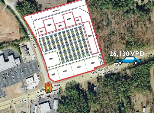
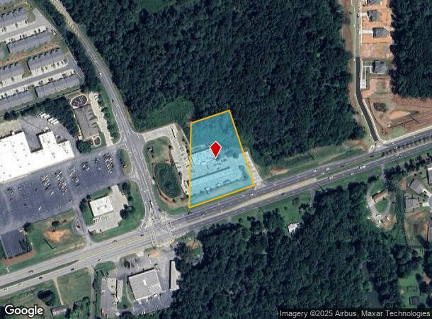
5410 Dallas Hwy Sw
19-0144-0-004-0
DEVELOPMENT LAND
Supermarket
Cobb
X
Georgia
13067C0086G
2.08 AC
2025
Kennesaw/Town Center
2025
Atlanta
120306
Atlanta-Sandy Springs-Roswell, GA
5,400 SF
DEMOGRAPHICS near 5410 Dallas Hwy Sw
1 Mile
3 Mile
5 Mile
2024 Total Population
3,620
37,008
108,999
2029 Population
3,961
39,532
116,543
Pop Growth 2024-2029
+ 9.42%
+ 6.82%
+ 6.92%
Average Age
40
40
40
2024 Total Households
1,221
12,403
37,184
HH Growth 2024-2029
+ 9.66%
+ 7.12%
+ 7.24%
Median Household Inc
$108,724
$118,889
$111,691
Avg Household Size
2.90
2.90
2.90
2024 Avg HH Vehicles
2.00
2.00
2.00
Median Home Value
$332,563
$356,625
$346,002
Median Year Built
1992
1995
1997
Nearby Places
- Restaurants
- Banks
- Shops
- Fitness
- Groceries
PUBLIC TRANSPORTATION
AIRPORT
Hartsfield - Jackson Atlanta International
DRIVE
WALK
Distance
Hartsfield - Jackson Atlanta International
57 min
38.6 mi
Freight Ports
Georgia Ports - Savannah
DRIVE
WALK
Distance
Georgia Ports - Savannah
320 min
277.9 mi
Nearby Properties
Address
Land Use
TOTAL SIZE
Lot Size
Zoning
Address
Land Use
TOTAL SIZE
Lot Size
Zoning
46.05 AC
Address
Land Use
TOTAL SIZE
Lot Size
Zoning
37.28 AC
Address
Land Use
TOTAL SIZE
Lot Size
Zoning
174,472 SF
60.63 AC
Address
Land Use
TOTAL SIZE
Lot Size
Zoning
223,686 SF
30.20 AC
B2
Address
Land Use
TOTAL SIZE
Lot Size
Zoning
Address
Land Use
TOTAL SIZE
Lot Size
Zoning
138,725 SF
11.66 AC
B2
Address
Land Use
TOTAL SIZE
Lot Size
Zoning
151,906 SF
21.07 AC
B2
Address
Land Use
TOTAL SIZE
Lot Size
Zoning
99,972 SF
3.18 AC
NRC/O&I
Address
Land Use
TOTAL SIZE
Lot Size
Zoning
44,972 SF
7.81 AC
B2
Address
Land Use
TOTAL SIZE
Lot Size
Zoning
71,301 SF
3.88 AC
B1
Address
Land Use
TOTAL SIZE
Lot Size
Zoning
74,036 SF
23.20 AC
B2
Address
Land Use
TOTAL SIZE
Lot Size
Zoning
151.43 AC
Address
Land Use
TOTAL SIZE
Lot Size
Zoning
28,886 SF
18 AC
Address
Land Use
TOTAL SIZE
Lot Size
Zoning
73,040 SF
5.96 AC
B2
Address
Land Use
TOTAL SIZE
Lot Size
Zoning
75,856 SF
10.06 AC
B2
Address
Land Use
TOTAL SIZE
Lot Size
Zoning
52,413 SF
7.57 AC
B2
Address
Land Use
TOTAL SIZE
Lot Size
Zoning
14,314 SF
2.73 AC
Address
Land Use
TOTAL SIZE
Lot Size
Zoning
14,616 SF
2.12 AC
GC
Address
Land Use
TOTAL SIZE
Lot Size
Zoning
16,288 SF
1.96 AC
B2
Address
Land Use
TOTAL SIZE
Lot Size
Zoning
20,324 SF
1.82 AC
B2
Address
Land Use
TOTAL SIZE
Lot Size
Zoning
21,460 SF
2.87 AC
B2
Address
Land Use
TOTAL SIZE
Lot Size
Zoning
9.80 AC
R30
Address
Land Use
TOTAL SIZE
Lot Size
Zoning
62,232 SF
2.02 AC
B2
Address
Land Use
TOTAL SIZE
Lot Size
Zoning
15,035 SF
2.40 AC
CRC
Address
Land Use
TOTAL SIZE
Lot Size
Zoning
1,626 SF
10.11 AC
Address
Land Use
TOTAL SIZE
Lot Size
Zoning
6,713 SF
3.62 AC
GC/WS
Address
Land Use
TOTAL SIZE
Lot Size
Zoning
17,612 SF
1.61 AC
NRC
Address
Land Use
TOTAL SIZE
Lot Size
Zoning
14 AC
R30
Address
Land Use
TOTAL SIZE
Lot Size
Zoning
56,256 SF
3 AC
B2-0
Address
Land Use
TOTAL SIZE
Lot Size
Zoning
18,289 SF
47.06 AC
R30
The World's #1 Commercial Real Estate Marketplace
Connect with us
© 2025 CoStar Group
The information above has been obtained from sources believed reliable. While we do not doubt its accuracy we have not verified it and make no guarantee, warranty or representation about it. It is your responsibility to independently confirm its accuracy and completeness. Any projections, opinions, assumptions, or estimates used are for example only and do not represent the current or future performance of the property. The value of this transaction to you depends on tax and other factors which should be evaluated by your tax, financial, and legal advisors. You and your advisors should conduct a careful, independent investigation of the property to determine to your satisfaction the suitability of the property for your needs.