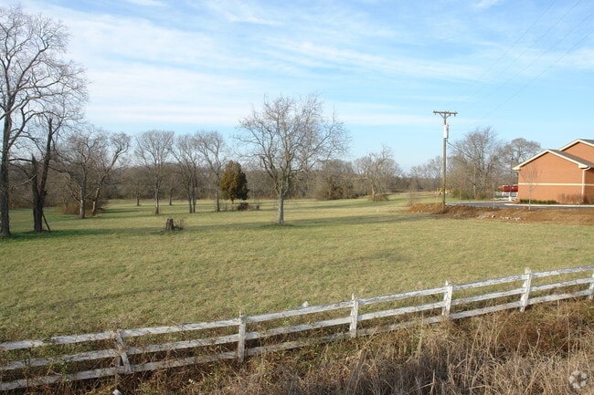
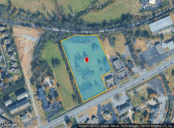
Property Record
E Main St, Hendersonville, TN 37075

NEARBY LISTINGS FOR SALE OR LEASE
Property Detail
E Main St
Nashville-Davidson--Murfreesboro--Franklin, TN
Cash S/D Resub
146-062.01
PLAT: 17 PAGE: 373 BLOCK: LOT: 2 SUBD: CASH S/D RESUB
Residentialacreage
Sumner
X
Tennessee
47165C0404G
2
2024
6.19 AC
2025
Rivergate/Hendersonville
021205
Nashville
DEMOGRAPHICS near E Main St
1 Mile
3 Mile
5 Mile
2024 Total Population
5,279
38,960
91,294
2029 Population
5,895
43,701
102,392
Pop Growth 2024-2029
+ 11.67%
+ 12.17%
+ 12.16%
Average Age
43
40
41
2024 Total Households
1,978
14,459
35,169
HH Growth 2024-2029
+ 11.88%
+ 12.30%
+ 12.35%
Median Household Inc
$101,867
$91,459
$84,036
Avg Household Size
2.60
2.70
2.60
2024 Avg HH Vehicles
2.00
2.00
2.00
Median Home Value
$403,795
$394,229
$380,668
Median Year Built
1996
1997
1995
Nearby Places
Map Layers
Map Styles
 Street
 Aerial
- Restaurants
- Banks
- Shops
- Fitness
- Groceries
PUBLIC TRANSPORTATION
AIRPORT
Nashville International
DRIVE
WALK
Distance
Nashville International
36 min
29.1 mi
Freight Ports
Port of Mobile
DRIVE
WALK
Distance
Port of Mobile
509 min
466.6 mi
SALE & LEASE HISTORY
LISTING DATE
SALE/LEASE

Sep 24, 2016
For Sale
Nearby Properties
Address
Land Use
TOTAL SIZE
Lot Size
Zoning
Address
Land Use
TOTAL SIZE
Lot Size
Zoning
31,163 SF
24.37 AC
Address
Land Use
TOTAL SIZE
Lot Size
Zoning
10,208 SF
29.53 AC
ESTATEA
Address
Land Use
TOTAL SIZE
Lot Size
Zoning
154,761 SF
8.74 AC
GCS
Address
Land Use
TOTAL SIZE
Lot Size
Zoning
46,650 SF
17.41 AC
MRO
Address
Land Use
TOTAL SIZE
Lot Size
Zoning
56,782 SF
11.37 AC
Address
Land Use
TOTAL SIZE
Lot Size
Zoning
84,210 SF
8.05 AC
GCS
Address
Land Use
TOTAL SIZE
Lot Size
Zoning
8,336 SF
18.34 AC
GCS
Address
Land Use
TOTAL SIZE
Lot Size
Zoning
81,584 SF
5.99 AC
Address
Land Use
TOTAL SIZE
Lot Size
Zoning
47,319 SF
7.52 AC
Address
Land Use
TOTAL SIZE
Lot Size
Zoning
169,864 SF
5.29 AC
GCS
Address
Land Use
TOTAL SIZE
Lot Size
Zoning
32,481 SF
9.42 AC
GCS
Address
Land Use
TOTAL SIZE
Lot Size
Zoning
105,942 SF
14.80 AC
GCS
Address
Land Use
TOTAL SIZE
Lot Size
Zoning
77,028 SF
12.78 AC
GCS
Address
Land Use
TOTAL SIZE
Lot Size
Zoning
218,472 SF
27.08 AC
GCS
Address
Land Use
TOTAL SIZE
Lot Size
Zoning
11,274 SF
15.30 AC
Address
Land Use
TOTAL SIZE
Lot Size
Zoning
142,403 SF
18.78 AC
NCS
Address
Land Use
TOTAL SIZE
Lot Size
Zoning
15,105 SF
13.35 AC
Address
Land Use
TOTAL SIZE
Lot Size
Zoning
27,038 SF
4.05 AC
Address
Land Use
TOTAL SIZE
Lot Size
Zoning
105,542 SF
9.09 AC
GCS
Address
Land Use
TOTAL SIZE
Lot Size
Zoning
21,213 SF
6.56 AC
Address
Land Use
TOTAL SIZE
Lot Size
Zoning
27,148 SF
8 AC
Address
Land Use
TOTAL SIZE
Lot Size
Zoning
Address
Land Use
TOTAL SIZE
Lot Size
Zoning
131,339 SF
18.22 AC
Address
Land Use
TOTAL SIZE
Lot Size
Zoning
99,333 SF
1.73 AC
ESTATEA
Address
Land Use
TOTAL SIZE
Lot Size
Zoning
154,556 SF
16.26 AC
Address
Land Use
TOTAL SIZE
Lot Size
Zoning
63,662 SF
3.79 AC
GCS
Address
Land Use
TOTAL SIZE
Lot Size
Zoning
35,022 SF
5.18 AC
GCS
Address
Land Use
TOTAL SIZE
Lot Size
Zoning
52,364 SF
5.78 AC
OPS
Address
Land Use
TOTAL SIZE
Lot Size
Zoning
22,364 SF
5 AC
Address
Land Use
TOTAL SIZE
Lot Size
Zoning
26,848 SF
21.70 AC
OPS
The World's #1 Commercial Real Estate Marketplace
Connect with us
© 2025 CoStar Group
The information above has been obtained from sources believed reliable. While we do not doubt its accuracy we have not verified it and make no guarantee, warranty or representation about it. It is your responsibility to independently confirm its accuracy and completeness. Any projections, opinions, assumptions, or estimates used are for example only and do not represent the current or future performance of the property. The value of this transaction to you depends on tax and other factors which should be evaluated by your tax, financial, and legal advisors. You and your advisors should conduct a careful, independent investigation of the property to determine to your satisfaction the suitability of the property for your needs.