Property Record
Sw 59Th St, Oklahoma City, OK 73179
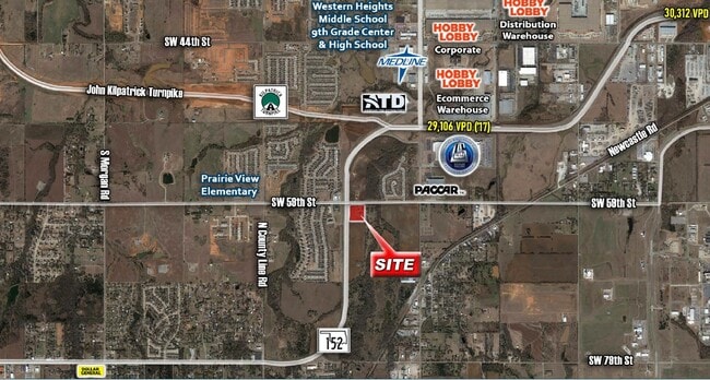
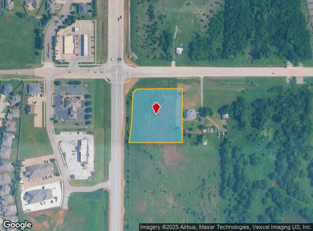
This Property Is For Sale
NEARBY LISTINGS FOR SALE OR LEASE
Property Detail
Sw 59Th St
Oklahoma City, OK
Unpltd Pt Sec 30 11N 4W
141422015
MUSTANG TOWNSHIP PT OF NE4 SEC 30 11N 4W BEG 536.58FT E & 80FT S OF NW/C NE4 TH S334.71FT W320.59FT N19.16FT NE100.84FT N195FT NE29.03FT E285FT TO BEG CONT 2.37ACRS MORE OR LESS
Residentialacreage
Oklahoma
X
Oklahoma
40027C0025J
2.37 AC
2023
West/Central
2024
Oklahoma City
1086032030
DEMOGRAPHICS near Sw 59Th St
1 Mile
3 Mile
5 Mile
2024 Total Population
4,666
20,767
70,028
2029 Population
4,899
23,801
81,451
Pop Growth 2024-2029
+ 4.99%
+ 14.61%
+ 16.31%
Average Age
36
37
36
2024 Total Households
1,171
6,787
25,261
HH Growth 2024-2029
+ 7.17%
+ 15.31%
+ 16.57%
Median Household Inc
$89,901
$89,903
$71,727
Avg Household Size
2.90
2.80
2.70
2024 Avg HH Vehicles
2.00
2.00
2.00
Median Home Value
$187,978
$219,590
$189,668
Median Year Built
2010
2006
1998
Nearby Places
Map Layers
Map Styles
 Street
 Aerial
- Restaurants
- Banks
- Shops
- Fitness
- Groceries
PUBLIC TRANSPORTATION
AIRPORT
Will Rogers World
DRIVE
WALK
Distance
Will Rogers World
14 min
6.8 mi
Nearby Properties
Address
Land Use
TOTAL SIZE
Lot Size
Zoning
Address
Land Use
TOTAL SIZE
Lot Size
Zoning
1,976,300 SF
217.95 AC
I-2
Address
Land Use
TOTAL SIZE
Lot Size
Zoning
1,953,545 SF
111.96 AC
PUD
Address
Land Use
TOTAL SIZE
Lot Size
Zoning
1,563,794 SF
127.94 AC
PUD
Address
Land Use
TOTAL SIZE
Lot Size
Zoning
52,170 SF
14.24 AC
Address
Land Use
TOTAL SIZE
Lot Size
Zoning
2,141,947 SF
98.48 AC
I-2
Address
Land Use
TOTAL SIZE
Lot Size
Zoning
653,359 SF
142.11 AC
I-2
Address
Land Use
TOTAL SIZE
Lot Size
Zoning
1,013,603 SF
66.29 AC
PUD
Address
Land Use
TOTAL SIZE
Lot Size
Zoning
33,313 SF
9.24 AC
Address
Land Use
TOTAL SIZE
Lot Size
Zoning
647,520 SF
28.23 AC
PUD
Address
Land Use
TOTAL SIZE
Lot Size
Zoning
784,972 SF
68.99 AC
I-2
Address
Land Use
TOTAL SIZE
Lot Size
Zoning
17,582 SF
4.34 AC
Address
Land Use
TOTAL SIZE
Lot Size
Zoning
720,640 SF
52.69 AC
PUD
Address
Land Use
TOTAL SIZE
Lot Size
Zoning
10,871 SF
3.68 AC
Address
Land Use
TOTAL SIZE
Lot Size
Zoning
143,450 SF
21.45 AC
Address
Land Use
TOTAL SIZE
Lot Size
Zoning
305,154 SF
33.30 AC
I-2
Address
Land Use
TOTAL SIZE
Lot Size
Zoning
538,787 SF
34.39 AC
I-2
Address
Land Use
TOTAL SIZE
Lot Size
Zoning
215,392 SF
63.71 AC
I-2
Address
Land Use
TOTAL SIZE
Lot Size
Zoning
9,928 SF
2.25 AC
Address
Land Use
TOTAL SIZE
Lot Size
Zoning
9.28 AC
I-2
Address
Land Use
TOTAL SIZE
Lot Size
Zoning
504 SF
16.38 AC
Address
Land Use
TOTAL SIZE
Lot Size
Zoning
615,435 SF
35.60 AC
I-3
Address
Land Use
TOTAL SIZE
Lot Size
Zoning
256,500 SF
19.46 AC
I-3
Address
Land Use
TOTAL SIZE
Lot Size
Zoning
7,560 SF
2.64 AC
Address
Land Use
TOTAL SIZE
Lot Size
Zoning
257,100 SF
33.19 AC
I-2
Address
Land Use
TOTAL SIZE
Lot Size
Zoning
223,600 SF
25.57 AC
I-2
Address
Land Use
TOTAL SIZE
Lot Size
Zoning
124,208 SF
21.48 AC
I-2
Address
Land Use
TOTAL SIZE
Lot Size
Zoning
89,152 SF
29.84 AC
PUD
Address
Land Use
TOTAL SIZE
Lot Size
Zoning
422,608 SF
24.97 AC
I-3
Address
Land Use
TOTAL SIZE
Lot Size
Zoning
1 SF
74.72 AC
PUD
Address
Land Use
TOTAL SIZE
Lot Size
Zoning
4,588 SF
3.90 AC
The World's #1 Commercial Real Estate Marketplace
Connect with us
© 2026 CoStar Group
The information above has been obtained from sources believed reliable. While we do not doubt its accuracy we have not verified it and make no guarantee, warranty or representation about it. It is your responsibility to independently confirm its accuracy and completeness. Any projections, opinions, assumptions, or estimates used are for example only and do not represent the current or future performance of the property. The value of this transaction to you depends on tax and other factors which should be evaluated by your tax, financial, and legal advisors. You and your advisors should conduct a careful, independent investigation of the property to determine to your satisfaction the suitability of the property for your needs.