Property Record
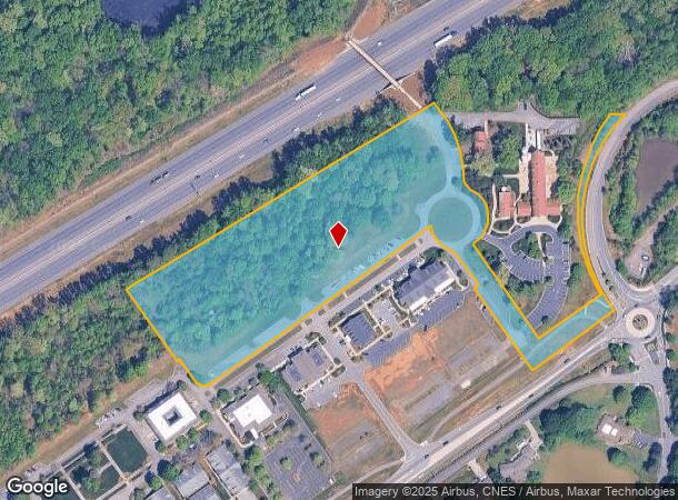
244 E Kinderton Way, Advance, NC 27006
NEARBY LISTINGS FOR SALE OR LEASE
Property Detail
244 E Kinderton Way
C8-000-00-178
Kinderton Commercial Village Core
Vacantlandnec
18.393 AC E OF COMMERCIAL
X
Davie
3710587200K
North Carolina
2025
8.86 AC
2025
Davie County
080302
Greensboro/Winston-Salem
1,688 SF
Winston-Salem, NC
DEMOGRAPHICS near 244 E Kinderton Way
1 Mile
3 Mile
5 Mile
2024 Total Population
3,375
21,270
46,324
2029 Population
3,645
22,500
48,746
Pop Growth 2024-2029
+ 8.00%
+ 5.78%
+ 5.23%
Average Age
49
46
44
2024 Total Households
1,553
8,661
18,687
HH Growth 2024-2029
+ 7.79%
+ 5.82%
+ 5.21%
Median Household Inc
$69,583
$98,327
$86,437
Avg Household Size
2.20
2.40
2.40
2024 Avg HH Vehicles
2.00
2.00
2.00
Median Home Value
$268,528
$310,536
$281,861
Median Year Built
1983
1991
1991
Nearby Places
Map Layers
Map Styles
 Street
 Aerial
- Restaurants
- Banks
- Shops
- Fitness
- Groceries
PUBLIC TRANSPORTATION
AIRPORT
Piedmont Triad International
DRIVE
WALK
Distance
Piedmont Triad International
47 min
32.8 mi
Freight Ports
Port of Wilmington
DRIVE
WALK
Distance
Port of Wilmington
285 min
241.5 mi
Nearby Properties
Address
Land Use
TOTAL SIZE
Lot Size
Zoning
Address
Land Use
TOTAL SIZE
Lot Size
Zoning
132,856 SF
53.61 AC
R20
Address
Land Use
TOTAL SIZE
Lot Size
Zoning
130,696 SF
41.18 AC
PB-S
Address
Land Use
TOTAL SIZE
Lot Size
Zoning
100,233 SF
19.65 AC
PB-S
Address
Land Use
TOTAL SIZE
Lot Size
Zoning
81,594 SF
1,147.49 AC
IP
Address
Land Use
TOTAL SIZE
Lot Size
Zoning
23,926 SF
11.36 AC
Address
Land Use
TOTAL SIZE
Lot Size
Zoning
60,258 SF
8.04 AC
PB-S
Address
Land Use
TOTAL SIZE
Lot Size
Zoning
49,319 SF
24.81 AC
Address
Land Use
TOTAL SIZE
Lot Size
Zoning
1,971 SF
6.24 AC
HB
Address
Land Use
TOTAL SIZE
Lot Size
Zoning
655,160 SF
52.15 AC
GI
Address
Land Use
TOTAL SIZE
Lot Size
Zoning
80,171 SF
4.32 AC
PB-S
Address
Land Use
TOTAL SIZE
Lot Size
Zoning
116,655 SF
10.16 AC
LI
Address
Land Use
TOTAL SIZE
Lot Size
Zoning
60,296 SF
0.66 AC
PB-S
Address
Land Use
TOTAL SIZE
Lot Size
Zoning
68,277 SF
9.82 AC
GB-S
Address
Land Use
TOTAL SIZE
Lot Size
Zoning
79,498 SF
10.64 AC
HB
Address
Land Use
TOTAL SIZE
Lot Size
Zoning
71,306 SF
10.36 AC
IP-S
Address
Land Use
TOTAL SIZE
Lot Size
Zoning
129,268 SF
9.98 AC
HB-S
Address
Land Use
TOTAL SIZE
Lot Size
Zoning
101,346 SF
8.25 AC
HB-S
Address
Land Use
TOTAL SIZE
Lot Size
Zoning
46,073 SF
11.74 AC
R12
Address
Land Use
TOTAL SIZE
Lot Size
Zoning
53,969 SF
10.52 AC
RM12-S
Address
Land Use
TOTAL SIZE
Lot Size
Zoning
119,240 SF
22.72 AC
Address
Land Use
TOTAL SIZE
Lot Size
Zoning
32,696 SF
1.64 AC
PB-S
Address
Land Use
TOTAL SIZE
Lot Size
Zoning
32,656 SF
3.14 AC
IP-S
Address
Land Use
TOTAL SIZE
Lot Size
Zoning
68,028 SF
17.56 AC
IP
Address
Land Use
TOTAL SIZE
Lot Size
Zoning
79,355 SF
14.91 AC
IP-S
Address
Land Use
TOTAL SIZE
Lot Size
Zoning
60,709 SF
34.21 AC
C-S
Address
Land Use
TOTAL SIZE
Lot Size
Zoning
59,143 SF
8.49 AC
CS
Address
Land Use
TOTAL SIZE
Lot Size
Zoning
53,105 SF
5.42 AC
IP-S
Address
Land Use
TOTAL SIZE
Lot Size
Zoning
37,658 SF
3.93 AC
RM12-S
Address
Land Use
TOTAL SIZE
Lot Size
Zoning
38,727 SF
6.84 AC
RM8-S
Address
Land Use
TOTAL SIZE
Lot Size
Zoning
62,524 SF
6.79 AC
PB-S
The World's #1 Commercial Real Estate Marketplace
Connect with us
© 2025 CoStar Group
The information above has been obtained from sources believed reliable. While we do not doubt its accuracy we have not verified it and make no guarantee, warranty or representation about it. It is your responsibility to independently confirm its accuracy and completeness. Any projections, opinions, assumptions, or estimates used are for example only and do not represent the current or future performance of the property. The value of this transaction to you depends on tax and other factors which should be evaluated by your tax, financial, and legal advisors. You and your advisors should conduct a careful, independent investigation of the property to determine to your satisfaction the suitability of the property for your needs.