Property Record
Yarborough Rd, Fort Mill, SC 29707

NEARBY LISTINGS FOR SALE OR LEASE
-
-
No Photo
-
-
-
-
-
-
View all Fort Mill listings for sale on LoopNet.com
Property Detail
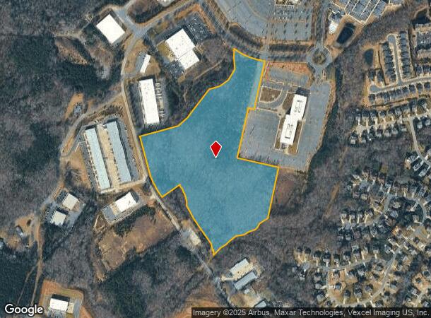
Yarborough Rd
0007-00-025.00
Bailes Ridge Business Park
Commercialnec
Lancaster
X
South Carolina
45057C0076E
23.19 AC
2024
Lancaster County
2024
Charlotte
011205
Charlotte-Concord-Gastonia, NC-SC
DEMOGRAPHICS near Yarborough Rd
1 Mile
3 Mile
5 Mile
2024 Total Population
6,634
44,338
126,190
2029 Population
8,157
51,172
141,127
Pop Growth 2024-2029
+ 22.96%
+ 15.41%
+ 11.84%
Average Age
38
37
39
2024 Total Households
2,458
16,093
46,082
HH Growth 2024-2029
+ 23.19%
+ 15.57%
+ 11.98%
Median Household Inc
$108,052
$115,862
$118,210
Avg Household Size
2.70
2.70
2.70
2024 Avg HH Vehicles
2.00
2.00
2.00
Median Home Value
$341,766
$389,930
$406,607
Median Year Built
2010
2008
2005
Nearby Places
- Restaurants
- Banks
- Shops
- Fitness
- Groceries
PUBLIC TRANSPORTATION
AIRPORT
Charlotte/Douglas International
DRIVE
WALK
Distance
Charlotte/Douglas International
33 min
19.6 mi
Concord-Padgett Regional
DRIVE
WALK
Distance
Concord-Padgett Regional
52 min
40.8 mi
Freight Ports
North Charleston Terminal
DRIVE
WALK
Distance
North Charleston Terminal
215 min
187.8 mi
Nearby Properties
Address
Land Use
TOTAL SIZE
Lot Size
Zoning
Address
Land Use
TOTAL SIZE
Lot Size
Zoning
348,409 SF
26.08 AC
R17MFCD
Address
Land Use
TOTAL SIZE
Lot Size
Zoning
211,609 SF
6.91 AC
UR2CD
Address
Land Use
TOTAL SIZE
Lot Size
Zoning
182,180 SF
7.31 AC
MX2
Address
Land Use
TOTAL SIZE
Lot Size
Zoning
137,210 SF
4.52 AC
Address
Land Use
TOTAL SIZE
Lot Size
Zoning
90,466 SF
105.72 AC
INST
Address
Land Use
TOTAL SIZE
Lot Size
Zoning
120,698 SF
5.18 AC
Address
Land Use
TOTAL SIZE
Lot Size
Zoning
74,000 SF
20.51 AC
O-1(CD)
Address
Land Use
TOTAL SIZE
Lot Size
Zoning
86,368 SF
11.28 AC
NS
Address
Land Use
TOTAL SIZE
Lot Size
Zoning
74,604 SF
2.26 AC
Address
Land Use
TOTAL SIZE
Lot Size
Zoning
77,646 SF
13.89 AC
Address
Land Use
TOTAL SIZE
Lot Size
Zoning
228.10 AC
MX-1(INNOV
Address
Land Use
TOTAL SIZE
Lot Size
Zoning
108,195 SF
28.29 AC
INS
Address
Land Use
TOTAL SIZE
Lot Size
Zoning
3,187 SF
182.31 AC
R-3
Address
Land Use
TOTAL SIZE
Lot Size
Zoning
68,300 SF
10.11 AC
B1CD
Address
Land Use
TOTAL SIZE
Lot Size
Zoning
50,462 SF
15.68 AC
Address
Land Use
TOTAL SIZE
Lot Size
Zoning
95,726 SF
49.65 AC
INS
Address
Land Use
TOTAL SIZE
Lot Size
Zoning
3,150 SF
161.39 AC
MX-1(INNOV
Address
Land Use
TOTAL SIZE
Lot Size
Zoning
61,867 SF
3.98 AC
UR2CD
Address
Land Use
TOTAL SIZE
Lot Size
Zoning
51,633 SF
1.44 AC
UR2CD
Address
Land Use
TOTAL SIZE
Lot Size
Zoning
71,872 SF
2.37 AC
NS
Address
Land Use
TOTAL SIZE
Lot Size
Zoning
10,783 SF
71.71 AC
R-40 MARVI
Address
Land Use
TOTAL SIZE
Lot Size
Zoning
19,876 SF
2.20 AC
NS
Address
Land Use
TOTAL SIZE
Lot Size
Zoning
70,350 SF
4.85 AC
INST(CD)
Address
Land Use
TOTAL SIZE
Lot Size
Zoning
26.20 AC
MX
Address
Land Use
TOTAL SIZE
Lot Size
Zoning
11,723 SF
3.53 AC
O-1(CD)
Address
Land Use
TOTAL SIZE
Lot Size
Zoning
11,625 SF
1.52 AC
B-1(CD)
Address
Land Use
TOTAL SIZE
Lot Size
Zoning
83.98 AC
GB
Address
Land Use
TOTAL SIZE
Lot Size
Zoning
6,416 SF
1.04 AC
Address
Land Use
TOTAL SIZE
Lot Size
Zoning
10,876 SF
7.30 AC
R3
Address
Land Use
TOTAL SIZE
Lot Size
Zoning
13,475 SF
39.11 AC
MX
The World's #1 Commercial Real Estate Marketplace
Connect with us
© 2025 CoStar Group
The information above has been obtained from sources believed reliable. While we do not doubt its accuracy we have not verified it and make no guarantee, warranty or representation about it. It is your responsibility to independently confirm its accuracy and completeness. Any projections, opinions, assumptions, or estimates used are for example only and do not represent the current or future performance of the property. The value of this transaction to you depends on tax and other factors which should be evaluated by your tax, financial, and legal advisors. You and your advisors should conduct a careful, independent investigation of the property to determine to your satisfaction the suitability of the property for your needs.