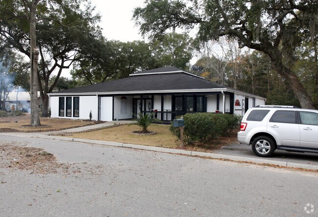
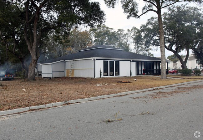
Property Record
4500 Highway 17, Murrells Inlet, SC 29576

NEARBY LISTINGS FOR SALE OR LEASE
Property Detail
4500 Highway 17
41-0119-003-06-00
Prop Sub
Restaurantbuilding
TRACT A INLET PROP SUB SLD 508-5; SLD 847-6
X
Georgetown
45043C0241G
South Carolina
2025
3.03 AC
2024
Myrtle Beach South
920511
Other Market Areas
4,130 SF
Georgetown, SC
DEMOGRAPHICS near 4500 Highway 17
1 Mile
3 Mile
5 Mile
2024 Total Population
3,776
19,532
40,610
2029 Population
3,960
21,965
47,750
Pop Growth 2024-2029
+ 4.87%
+ 12.46%
+ 17.58%
Average Age
52
53
53
2024 Total Households
1,845
9,220
19,297
HH Growth 2024-2029
+ 4.55%
+ 11.53%
+ 16.60%
Median Household Inc
$55,416
$64,463
$63,240
Avg Household Size
2.00
2.10
2.10
2024 Avg HH Vehicles
2.00
2.00
2.00
Median Home Value
$269,955
$283,702
$262,208
Median Year Built
1997
2001
1998
Nearby Places
Map Layers
Map Styles
 Street
 Aerial
- Restaurants
- Banks
- Shops
- Fitness
- Groceries
PUBLIC TRANSPORTATION
AIRPORT
Myrtle Beach International
DRIVE
WALK
Distance
Myrtle Beach International
24 min
15.7 mi
Freight Ports
Wando Welch Terminal
DRIVE
WALK
Distance
Wando Welch Terminal
100 min
75.4 mi
Nearby Properties
Address
Land Use
TOTAL SIZE
Lot Size
Zoning
Address
Land Use
TOTAL SIZE
Lot Size
Zoning
20.55 AC
Address
Land Use
TOTAL SIZE
Lot Size
Zoning
8,169 SF
2.70 AC
Address
Land Use
TOTAL SIZE
Lot Size
Zoning
37,976 SF
3.76 AC
Address
Land Use
TOTAL SIZE
Lot Size
Zoning
Address
Land Use
TOTAL SIZE
Lot Size
Zoning
13,244 SF
3.50 AC
Address
Land Use
TOTAL SIZE
Lot Size
Zoning
Address
Land Use
TOTAL SIZE
Lot Size
Zoning
3,696 SF
55.20 AC
Address
Land Use
TOTAL SIZE
Lot Size
Zoning
15,704 SF
1.97 AC
Address
Land Use
TOTAL SIZE
Lot Size
Zoning
4.60 AC
Address
Land Use
TOTAL SIZE
Lot Size
Zoning
10,532 SF
2.90 AC
Address
Land Use
TOTAL SIZE
Lot Size
Zoning
5,570 SF
21.44 AC
Address
Land Use
TOTAL SIZE
Lot Size
Zoning
Address
Land Use
TOTAL SIZE
Lot Size
Zoning
6,170 SF
2.50 AC
Address
Land Use
TOTAL SIZE
Lot Size
Zoning
Address
Land Use
TOTAL SIZE
Lot Size
Zoning
Address
Land Use
TOTAL SIZE
Lot Size
Zoning
Address
Land Use
TOTAL SIZE
Lot Size
Zoning
Address
Land Use
TOTAL SIZE
Lot Size
Zoning
4,800 SF
75.54 AC
Address
Land Use
TOTAL SIZE
Lot Size
Zoning
5,230 SF
19.39 AC
Address
Land Use
TOTAL SIZE
Lot Size
Zoning
Address
Land Use
TOTAL SIZE
Lot Size
Zoning
64,620 SF
7.90 AC
Address
Land Use
TOTAL SIZE
Lot Size
Zoning
3,052 SF
1 AC
Address
Land Use
TOTAL SIZE
Lot Size
Zoning
Address
Land Use
TOTAL SIZE
Lot Size
Zoning
108,250 SF
14.53 AC
Address
Land Use
TOTAL SIZE
Lot Size
Zoning
3,343 SF
0.41 AC
Address
Land Use
TOTAL SIZE
Lot Size
Zoning
Address
Land Use
TOTAL SIZE
Lot Size
Zoning
8,640 SF
5.47 AC
Address
Land Use
TOTAL SIZE
Lot Size
Zoning
80,797 SF
33.77 AC
Address
Land Use
TOTAL SIZE
Lot Size
Zoning
2,496 SF
40.08 AC
The World's #1 Commercial Real Estate Marketplace
Connect with us
© 2026 CoStar Group
The information above has been obtained from sources believed reliable. While we do not doubt its accuracy we have not verified it and make no guarantee, warranty or representation about it. It is your responsibility to independently confirm its accuracy and completeness. Any projections, opinions, assumptions, or estimates used are for example only and do not represent the current or future performance of the property. The value of this transaction to you depends on tax and other factors which should be evaluated by your tax, financial, and legal advisors. You and your advisors should conduct a careful, independent investigation of the property to determine to your satisfaction the suitability of the property for your needs.