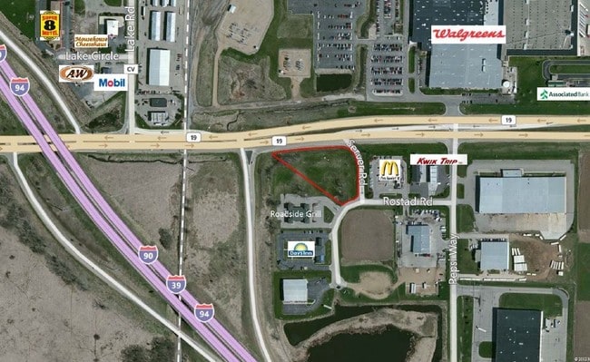
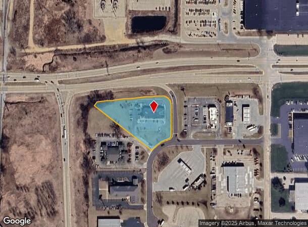
Property Record
6321 Rostad Cir, Windsor, WI 53598

NEARBY LISTINGS FOR SALE OR LEASE
Property Detail
6321 Rostad Cir
Madison, WI
Highway 19 Commercial Plat
0810-052-0350-8
HIGHWAY 19 COMMERCIAL PLAT LOT 3 SUBJ TO JT DRVWY AGRMNT 5053704
Commercialnec
Dane
X
Wisconsin
55025C0254H
3
2024
1.08 AC
2024
Northeast Madison
011404
Milwaukee/Madison
DEMOGRAPHICS near 6321 Rostad Cir
1 Mile
3 Mile
5 Mile
2024 Total Population
1,161
14,810
69,971
2029 Population
1,221
15,565
72,795
Pop Growth 2024-2029
+ 5.17%
+ 5.10%
+ 4.04%
Average Age
38
38
39
2024 Total Households
452
5,547
28,659
HH Growth 2024-2029
+ 5.09%
+ 5.17%
+ 4.19%
Median Household Inc
$103,571
$106,947
$81,893
Avg Household Size
2.50
2.60
2.40
2024 Avg HH Vehicles
2.00
2.00
2.00
Median Home Value
$366,666
$354,688
$304,718
Median Year Built
1995
1996
1992
Nearby Places
Map Layers
Map Styles
 Street
 Aerial
- Restaurants
- Banks
- Shops
- Fitness
- Groceries
PUBLIC TRANSPORTATION
AIRPORT
Dane County Regional/Truax Field
DRIVE
WALK
Distance
Dane County Regional/Truax Field
14 min
7.2 mi
Nearby Properties
Address
Land Use
TOTAL SIZE
Lot Size
Zoning
Address
Land Use
TOTAL SIZE
Lot Size
Zoning
385,400 SF
62.07 AC
IL
Address
Land Use
TOTAL SIZE
Lot Size
Zoning
48.24 AC
Address
Land Use
TOTAL SIZE
Lot Size
Zoning
107,751 SF
22.34 AC
IL
Address
Land Use
TOTAL SIZE
Lot Size
Zoning
Address
Land Use
TOTAL SIZE
Lot Size
Zoning
37.54 AC
Address
Land Use
TOTAL SIZE
Lot Size
Zoning
24.70 AC
Address
Land Use
TOTAL SIZE
Lot Size
Zoning
Address
Land Use
TOTAL SIZE
Lot Size
Zoning
Address
Land Use
TOTAL SIZE
Lot Size
Zoning
3.77 AC
Address
Land Use
TOTAL SIZE
Lot Size
Zoning
16.64 AC
Address
Land Use
TOTAL SIZE
Lot Size
Zoning
11.01 AC
C2
Address
Land Use
TOTAL SIZE
Lot Size
Zoning
13.27 AC
ETZ
Address
Land Use
TOTAL SIZE
Lot Size
Zoning
137,665 SF
9.39 AC
IL
Address
Land Use
TOTAL SIZE
Lot Size
Zoning
20.59 AC
C2
Address
Land Use
TOTAL SIZE
Lot Size
Zoning
3.60 AC
Address
Land Use
TOTAL SIZE
Lot Size
Zoning
14.08 AC
IL
Address
Land Use
TOTAL SIZE
Lot Size
Zoning
2.59 AC
Address
Land Use
TOTAL SIZE
Lot Size
Zoning
8.19 AC
Address
Land Use
TOTAL SIZE
Lot Size
Zoning
122,038 SF
9.03 AC
IL
Address
Land Use
TOTAL SIZE
Lot Size
Zoning
14.75 AC
Address
Land Use
TOTAL SIZE
Lot Size
Zoning
12.30 AC
C2
Address
Land Use
TOTAL SIZE
Lot Size
Zoning
3.72 AC
R-4
Address
Land Use
TOTAL SIZE
Lot Size
Zoning
14.52 AC
ETZ
Address
Land Use
TOTAL SIZE
Lot Size
Zoning
Address
Land Use
TOTAL SIZE
Lot Size
Zoning
47,012 SF
10.92 AC
IG
Address
Land Use
TOTAL SIZE
Lot Size
Zoning
Address
Land Use
TOTAL SIZE
Lot Size
Zoning
38.60 AC
Address
Land Use
TOTAL SIZE
Lot Size
Zoning
7.71 AC
ETZ
Address
Land Use
TOTAL SIZE
Lot Size
Zoning
3.72 AC
C2
Address
Land Use
TOTAL SIZE
Lot Size
Zoning
6.63 AC
The World's #1 Commercial Real Estate Marketplace
Connect with us
© 2025 CoStar Group
The information above has been obtained from sources believed reliable. While we do not doubt its accuracy we have not verified it and make no guarantee, warranty or representation about it. It is your responsibility to independently confirm its accuracy and completeness. Any projections, opinions, assumptions, or estimates used are for example only and do not represent the current or future performance of the property. The value of this transaction to you depends on tax and other factors which should be evaluated by your tax, financial, and legal advisors. You and your advisors should conduct a careful, independent investigation of the property to determine to your satisfaction the suitability of the property for your needs.