Property Record
E Irlo Bronson Memorial Hwy, Harmony, FL 34773
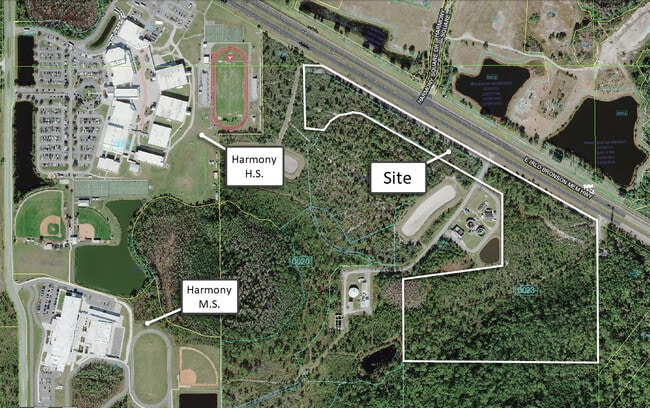
This Property Is For Sale
NEARBY LISTINGS FOR SALE OR LEASE
Property Detail
E Irlo Bronson Memorial Hwy
Orlando-Kissimmee-Sanford, FL
St Cloud Hwy East
30-26-32-0000-0023-0000
BEG AT INTER OF SLY R/W LINE OF US 192 & E/L OF NE 1/4 OF 31-26-32, N60-13-39W 2713.26 FT, S00-33-55E 254.30 FT, N89-57-13E 299.67 FT, S00-00-20W 426.74 FT, S77-16-24E 149.80 FT, N29-29-05E 35.13 FT, N11-53-34E 25.81 FT, N54-28-20E 91.52 FT, N74-39-1
Commercialacreage
Osceola
X
Florida
12097C0285G
1.27 AC
2024
Osceola Outlying
2025
Orlando
043802
DEMOGRAPHICS near E Irlo Bronson Memorial Hwy
1 Mile
3 Mile
5 Mile
2024 Total Population
931
5,338
8,391
2029 Population
1,163
6,665
10,356
Pop Growth 2024-2029
+ 24.92%
+ 24.86%
+ 23.42%
Average Age
36
36
38
2024 Total Households
287
1,647
2,752
HH Growth 2024-2029
+ 24.74%
+ 24.71%
+ 23.15%
Median Household Inc
$79,327
$79,859
$76,676
Avg Household Size
3.20
3.20
3.00
2024 Avg HH Vehicles
2.00
2.00
2.00
Median Home Value
$328,276
$328,588
$341,362
Median Year Built
2011
2011
2010
Nearby Places
Map Layers
Map Styles
 Street
 Aerial
- Restaurants
- Banks
- Shops
- Fitness
- Groceries
PUBLIC TRANSPORTATION
AIRPORT
Orlando International
DRIVE
WALK
Distance
Orlando International
43 min
28.5 mi
Freight Ports
Port Canaveral
DRIVE
WALK
Distance
Port Canaveral
77 min
63.6 mi
Nearby Properties
Address
Land Use
TOTAL SIZE
Lot Size
Zoning
Address
Land Use
TOTAL SIZE
Lot Size
Zoning
229,148 SF
47.05 AC
OAC
Address
Land Use
TOTAL SIZE
Lot Size
Zoning
121,656 SF
9.49 AC
OPD
Address
Land Use
TOTAL SIZE
Lot Size
Zoning
19,606 SF
100.40 AC
OAC
Address
Land Use
TOTAL SIZE
Lot Size
Zoning
28,429 SF
263.30 AC
OAC
Address
Land Use
TOTAL SIZE
Lot Size
Zoning
15,040 SF
5.13 AC
OPD
Address
Land Use
TOTAL SIZE
Lot Size
Zoning
20,046 SF
1.46 AC
OMXD
Address
Land Use
TOTAL SIZE
Lot Size
Zoning
108.50 AC
Address
Land Use
TOTAL SIZE
Lot Size
Zoning
Address
Land Use
TOTAL SIZE
Lot Size
Zoning
9.80 AC
Address
Land Use
TOTAL SIZE
Lot Size
Zoning
12,430 SF
3.02 AC
OPD
Address
Land Use
TOTAL SIZE
Lot Size
Zoning
16,500 SF
2.80 AC
OPD
Address
Land Use
TOTAL SIZE
Lot Size
Zoning
3,290 SF
1.60 AC
OPD
Address
Land Use
TOTAL SIZE
Lot Size
Zoning
253.20 AC
OAC
Address
Land Use
TOTAL SIZE
Lot Size
Zoning
10,348 SF
326.84 AC
OAC
Address
Land Use
TOTAL SIZE
Lot Size
Zoning
33,933 SF
13.54 AC
Address
Land Use
TOTAL SIZE
Lot Size
Zoning
Address
Land Use
TOTAL SIZE
Lot Size
Zoning
60.69 AC
AC
Address
Land Use
TOTAL SIZE
Lot Size
Zoning
5,951 SF
0.28 AC
OPD
Address
Land Use
TOTAL SIZE
Lot Size
Zoning
6.62 AC
OPD
Address
Land Use
TOTAL SIZE
Lot Size
Zoning
6.62 AC
OPD
Address
Land Use
TOTAL SIZE
Lot Size
Zoning
Address
Land Use
TOTAL SIZE
Lot Size
Zoning
16.13 AC
Address
Land Use
TOTAL SIZE
Lot Size
Zoning
4.39 AC
Address
Land Use
TOTAL SIZE
Lot Size
Zoning
1.58 AC
OMXD
Address
Land Use
TOTAL SIZE
Lot Size
Zoning
18.47 AC
AC
Address
Land Use
TOTAL SIZE
Lot Size
Zoning
20.05 AC
OAC
Address
Land Use
TOTAL SIZE
Lot Size
Zoning
19.48 AC
OAC
Address
Land Use
TOTAL SIZE
Lot Size
Zoning
2,354 SF
22.46 AC
OAC
Address
Land Use
TOTAL SIZE
Lot Size
Zoning
The World's #1 Commercial Real Estate Marketplace
Connect with us
© 2026 CoStar Group
The information above has been obtained from sources believed reliable. While we do not doubt its accuracy we have not verified it and make no guarantee, warranty or representation about it. It is your responsibility to independently confirm its accuracy and completeness. Any projections, opinions, assumptions, or estimates used are for example only and do not represent the current or future performance of the property. The value of this transaction to you depends on tax and other factors which should be evaluated by your tax, financial, and legal advisors. You and your advisors should conduct a careful, independent investigation of the property to determine to your satisfaction the suitability of the property for your needs.