Property Record
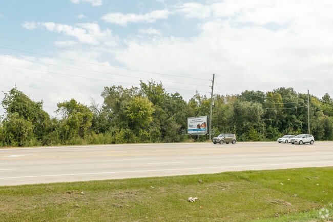
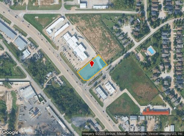
0 Tomball Pkwy, Houston, TX 77086
NEARBY LISTINGS FOR SALE OR LEASE
Property Detail
0 Tomball Pkwy
1402190010001
Shoppes At Sh 249
Commercialacreage
RES A BLK 1 SHOPPES AT SH 249
X
Harris
48201C0465M
Texas
2024
1.05 AC
2025
Northwest Far
533903
Houston
27,739 SF
Houston-The Woodlands-Sugar Land, TX
DEMOGRAPHICS near 0 Tomball Pkwy
1 Mile
3 Mile
5 Mile
2024 Total Population
11,358
117,703
312,572
2029 Population
11,540
118,875
316,893
Pop Growth 2024-2029
+ 1.60%
+ 1.00%
+ 1.38%
Average Age
34
35
35
2024 Total Households
3,309
35,342
100,496
HH Growth 2024-2029
+ 1.51%
+ 0.98%
+ 1.39%
Median Household Inc
$55,579
$47,701
$46,375
Avg Household Size
3.30
3.20
3.00
2024 Avg HH Vehicles
2.00
2.00
2.00
Median Home Value
$212,241
$159,200
$169,499
Median Year Built
2000
1980
1982
Nearby Places
Map Layers
Map Styles
 Street
 Aerial
- Restaurants
- Banks
- Shops
- Fitness
- Groceries
PUBLIC TRANSPORTATION
AIRPORT
George Bush Intcntl/Houston
DRIVE
WALK
Distance
George Bush Intcntl/Houston
21 min
15.1 mi
William P Hobby
DRIVE
WALK
Distance
William P Hobby
41 min
25.5 mi
Freight Ports
Port of Houston
DRIVE
WALK
Distance
Port of Houston
33 min
21.1 mi
SALE & LEASE HISTORY
LISTING DATE
SALE/LEASE

Dec 07, 2017
For Sale
Nearby Properties
Address
Land Use
TOTAL SIZE
Lot Size
Zoning
Address
Land Use
TOTAL SIZE
Lot Size
Zoning
145.62 AC
Address
Land Use
TOTAL SIZE
Lot Size
Zoning
614,256 SF
31.25 AC
Address
Land Use
TOTAL SIZE
Lot Size
Zoning
397,248 SF
26.37 AC
Address
Land Use
TOTAL SIZE
Lot Size
Zoning
718,600 SF
42.09 AC
Address
Land Use
TOTAL SIZE
Lot Size
Zoning
504,000 SF
32.25 AC
Address
Land Use
TOTAL SIZE
Lot Size
Zoning
424,122 SF
21.06 AC
Address
Land Use
TOTAL SIZE
Lot Size
Zoning
356,900 SF
19.38 AC
Address
Land Use
TOTAL SIZE
Lot Size
Zoning
292,112 SF
4.41 AC
Address
Land Use
TOTAL SIZE
Lot Size
Zoning
200,123 SF
14.94 AC
Address
Land Use
TOTAL SIZE
Lot Size
Zoning
287,510 SF
19.43 AC
Address
Land Use
TOTAL SIZE
Lot Size
Zoning
253,369 SF
16.81 AC
Address
Land Use
TOTAL SIZE
Lot Size
Zoning
261,000 SF
13.89 AC
Address
Land Use
TOTAL SIZE
Lot Size
Zoning
209,825 SF
11.97 AC
Address
Land Use
TOTAL SIZE
Lot Size
Zoning
397,012 SF
35.38 AC
Address
Land Use
TOTAL SIZE
Lot Size
Zoning
232,702 SF
14.75 AC
Address
Land Use
TOTAL SIZE
Lot Size
Zoning
221,810 SF
13.96 AC
Address
Land Use
TOTAL SIZE
Lot Size
Zoning
218,734 SF
11.24 AC
Address
Land Use
TOTAL SIZE
Lot Size
Zoning
333,286 SF
13.95 AC
Address
Land Use
TOTAL SIZE
Lot Size
Zoning
221,760 SF
13.99 AC
Address
Land Use
TOTAL SIZE
Lot Size
Zoning
361,869 SF
39.62 AC
Address
Land Use
TOTAL SIZE
Lot Size
Zoning
264,996 SF
18.95 AC
Address
Land Use
TOTAL SIZE
Lot Size
Zoning
190,543 SF
9.09 AC
Address
Land Use
TOTAL SIZE
Lot Size
Zoning
184,169 SF
8 AC
Address
Land Use
TOTAL SIZE
Lot Size
Zoning
239,721 SF
8.98 AC
Address
Land Use
TOTAL SIZE
Lot Size
Zoning
145,200 SF
10.65 AC
Address
Land Use
TOTAL SIZE
Lot Size
Zoning
283,375 SF
13 AC
Address
Land Use
TOTAL SIZE
Lot Size
Zoning
196,314 SF
9.63 AC
Address
Land Use
TOTAL SIZE
Lot Size
Zoning
164,197 SF
7.79 AC
Address
Land Use
TOTAL SIZE
Lot Size
Zoning
153,500 SF
10.65 AC
Address
Land Use
TOTAL SIZE
Lot Size
Zoning
172,118 SF
9.73 AC
The World's #1 Commercial Real Estate Marketplace
Connect with us
© 2026 CoStar Group
The information above has been obtained from sources believed reliable. While we do not doubt its accuracy we have not verified it and make no guarantee, warranty or representation about it. It is your responsibility to independently confirm its accuracy and completeness. Any projections, opinions, assumptions, or estimates used are for example only and do not represent the current or future performance of the property. The value of this transaction to you depends on tax and other factors which should be evaluated by your tax, financial, and legal advisors. You and your advisors should conduct a careful, independent investigation of the property to determine to your satisfaction the suitability of the property for your needs.