Property Record
Highway 321, Gaston, SC 29053
This Property Is For Sale
NEARBY LISTINGS FOR SALE OR LEASE
Property Detail
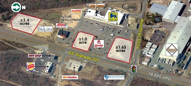
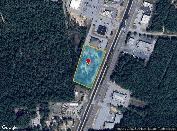
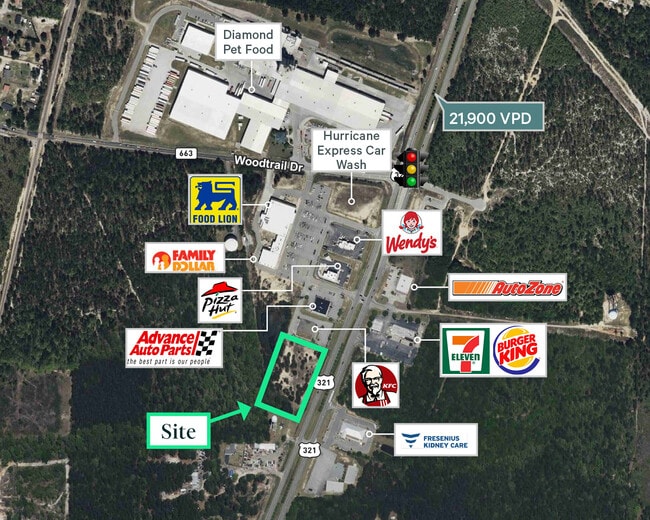
Highway 321
010100-02-268
PARCEL B
Commercialacreage
Lexington
X
South Carolina
45063C0405J
2.45 AC
2025
Cayce/West Columbia
2024
Columbia
020806
Columbia, SC
DEMOGRAPHICS near Highway 321
1 Mile
3 Mile
5 Mile
2024 Total Population
1,399
10,085
25,530
2029 Population
1,544
11,150
28,189
Pop Growth 2024-2029
+ 10.36%
+ 10.56%
+ 10.42%
Average Age
38
38
39
2024 Total Households
508
3,683
9,502
HH Growth 2024-2029
+ 10.63%
+ 10.72%
+ 10.53%
Median Household Inc
$42,090
$41,563
$47,304
Avg Household Size
2.70
2.60
2.60
2024 Avg HH Vehicles
2.00
2.00
2.00
Median Home Value
$88,755
$97,442
$105,024
Median Year Built
1993
1993
1991
Nearby Places
Map Layers
Map Styles
 Street
 Aerial
- Restaurants
- Banks
- Shops
- Fitness
- Groceries
PUBLIC TRANSPORTATION
AIRPORT
Columbia Metro
DRIVE
WALK
Distance
Columbia Metro
25 min
14.1 mi
Nearby Properties
Address
Land Use
TOTAL SIZE
Lot Size
Zoning
Address
Land Use
TOTAL SIZE
Lot Size
Zoning
9,180 SF
10.66 AC
Address
Land Use
TOTAL SIZE
Lot Size
Zoning
7,150 SF
2.46 AC
Address
Land Use
TOTAL SIZE
Lot Size
Zoning
12,400 SF
1.62 AC
RD
Address
Land Use
TOTAL SIZE
Lot Size
Zoning
5,880 SF
1.02 AC
Address
Land Use
TOTAL SIZE
Lot Size
Zoning
6,840 SF
0.82 AC
Address
Land Use
TOTAL SIZE
Lot Size
Zoning
18,358 SF
1.75 AC
RD
Address
Land Use
TOTAL SIZE
Lot Size
Zoning
3,360 SF
1.34 AC
RD
Address
Land Use
TOTAL SIZE
Lot Size
Zoning
23,387 SF
8.32 AC
ID
Address
Land Use
TOTAL SIZE
Lot Size
Zoning
268.24 AC
LR
Address
Land Use
TOTAL SIZE
Lot Size
Zoning
238.17 AC
RD
Address
Land Use
TOTAL SIZE
Lot Size
Zoning
5,828 SF
2.04 AC
Address
Land Use
TOTAL SIZE
Lot Size
Zoning
800 SF
418.19 AC
RD
Address
Land Use
TOTAL SIZE
Lot Size
Zoning
27.47 AC
ID
Address
Land Use
TOTAL SIZE
Lot Size
Zoning
1,216 SF
10.52 AC
RD
Address
Land Use
TOTAL SIZE
Lot Size
Zoning
3,153 SF
1 AC
Address
Land Use
TOTAL SIZE
Lot Size
Zoning
1,216 SF
7.47 AC
RD
Address
Land Use
TOTAL SIZE
Lot Size
Zoning
18,225 SF
2.37 AC
LR
Address
Land Use
TOTAL SIZE
Lot Size
Zoning
152.38 AC
LR
Address
Land Use
TOTAL SIZE
Lot Size
Zoning
2,400 SF
12 AC
RD
Address
Land Use
TOTAL SIZE
Lot Size
Zoning
134.04 AC
LR
Address
Land Use
TOTAL SIZE
Lot Size
Zoning
1,008 SF
9.82 AC
RD
Address
Land Use
TOTAL SIZE
Lot Size
Zoning
10,986 SF
187.28 AC
LR
Address
Land Use
TOTAL SIZE
Lot Size
Zoning
768 SF
37.65 AC
RD
Address
Land Use
TOTAL SIZE
Lot Size
Zoning
2,950 SF
57.30 AC
LR
Address
Land Use
TOTAL SIZE
Lot Size
Zoning
1.64 AC
Address
Land Use
TOTAL SIZE
Lot Size
Zoning
5,000 SF
3.43 AC
Address
Land Use
TOTAL SIZE
Lot Size
Zoning
6,791 SF
0.85 AC
Address
Land Use
TOTAL SIZE
Lot Size
Zoning
3,140 SF
0.99 AC
Address
Land Use
TOTAL SIZE
Lot Size
Zoning
2,400 SF
1.43 AC
LR
Address
Land Use
TOTAL SIZE
Lot Size
Zoning
176 AC
LR
The World's #1 Commercial Real Estate Marketplace
Connect with us
© 2026 CoStar Group
The information above has been obtained from sources believed reliable. While we do not doubt its accuracy we have not verified it and make no guarantee, warranty or representation about it. It is your responsibility to independently confirm its accuracy and completeness. Any projections, opinions, assumptions, or estimates used are for example only and do not represent the current or future performance of the property. The value of this transaction to you depends on tax and other factors which should be evaluated by your tax, financial, and legal advisors. You and your advisors should conduct a careful, independent investigation of the property to determine to your satisfaction the suitability of the property for your needs.