Property Record
Bethlehem Rd, Locust Grove, GA 30248
This Property Is For Sale
NEARBY LISTINGS FOR SALE OR LEASE
Property Detail
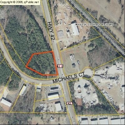
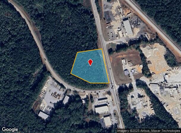
Bethlehem Rd
0111-01-013-008
LAND LOT: 248 /LAND DISTRICT: 2
Industrialacreage
Henry
X
Georgia
13151C0170D
0248
2025
1.84 AC
2025
South Clayton/Henry Cnty
070411
Atlanta
928 SF
Atlanta-Sandy Springs-Roswell, GA
DEMOGRAPHICS near Bethlehem Rd
1 Mile
3 Mile
5 Mile
2024 Total Population
1,060
14,627
63,614
2029 Population
1,145
16,128
70,095
Pop Growth 2024-2029
+ 8.02%
+ 10.26%
+ 10.19%
Average Age
37
37
36
2024 Total Households
344
5,032
21,972
HH Growth 2024-2029
+ 8.14%
+ 10.45%
+ 10.32%
Median Household Inc
$91,388
$70,422
$69,707
Avg Household Size
3.00
2.90
2.80
2024 Avg HH Vehicles
2.00
2.00
2.00
Median Home Value
$291,176
$251,662
$223,419
Median Year Built
2006
2005
2004
Nearby Places
Map Layers
Map Styles
 Street
 Aerial
- Restaurants
- Banks
- Shops
- Fitness
- Groceries
PUBLIC TRANSPORTATION
AIRPORT
Hartsfield - Jackson Atlanta International
DRIVE
WALK
Distance
Hartsfield - Jackson Atlanta International
38 min
28.1 mi
Nearby Properties
Address
Land Use
TOTAL SIZE
Lot Size
Zoning
Address
Land Use
TOTAL SIZE
Lot Size
Zoning
1,573,998 SF
84.31 AC
M2
Address
Land Use
TOTAL SIZE
Lot Size
Zoning
1,012,028 SF
98.01 AC
M1
Address
Land Use
TOTAL SIZE
Lot Size
Zoning
1,079,756 SF
92.38 AC
M1
Address
Land Use
TOTAL SIZE
Lot Size
Zoning
1,010,600 SF
78.40 AC
M1
Address
Land Use
TOTAL SIZE
Lot Size
Zoning
1,226,687 SF
100.81 AC
M2
Address
Land Use
TOTAL SIZE
Lot Size
Zoning
247,544 SF
43.30 AC
Address
Land Use
TOTAL SIZE
Lot Size
Zoning
2,337,242 SF
71.11 AC
M2
Address
Land Use
TOTAL SIZE
Lot Size
Zoning
4,307,236 SF
66.85 AC
M1
Address
Land Use
TOTAL SIZE
Lot Size
Zoning
765,316 SF
85.65 AC
M1
Address
Land Use
TOTAL SIZE
Lot Size
Zoning
7,005,327 SF
56.89 AC
M1
Address
Land Use
TOTAL SIZE
Lot Size
Zoning
1,588,692 SF
44.95 AC
M1
Address
Land Use
TOTAL SIZE
Lot Size
Zoning
415,997 SF
41.35 AC
Address
Land Use
TOTAL SIZE
Lot Size
Zoning
18,084 SF
59.72 AC
M1
Address
Land Use
TOTAL SIZE
Lot Size
Zoning
22,633 SF
31 AC
RM
Address
Land Use
TOTAL SIZE
Lot Size
Zoning
4,982 SF
34.62 AC
RM
Address
Land Use
TOTAL SIZE
Lot Size
Zoning
4,237,908 SF
44.42 AC
M
Address
Land Use
TOTAL SIZE
Lot Size
Zoning
21,308 SF
14.22 AC
M1
Address
Land Use
TOTAL SIZE
Lot Size
Zoning
660,000 SF
129.11 AC
M1
Address
Land Use
TOTAL SIZE
Lot Size
Zoning
1,456,864 SF
82.62 AC
Address
Land Use
TOTAL SIZE
Lot Size
Zoning
5,681,569 SF
37.80 AC
M1
Address
Land Use
TOTAL SIZE
Lot Size
Zoning
3,877,368 SF
44.93 AC
M2
Address
Land Use
TOTAL SIZE
Lot Size
Zoning
351,848 SF
41.63 AC
C2
Address
Land Use
TOTAL SIZE
Lot Size
Zoning
6,101,324 SF
42.27 AC
M1
Address
Land Use
TOTAL SIZE
Lot Size
Zoning
297,736 SF
57.04 AC
M
Address
Land Use
TOTAL SIZE
Lot Size
Zoning
532,585 SF
67.79 AC
M2
Address
Land Use
TOTAL SIZE
Lot Size
Zoning
1,122,282 SF
39.20 AC
M2
Address
Land Use
TOTAL SIZE
Lot Size
Zoning
2,603,368 SF
49.23 AC
M1
Address
Land Use
TOTAL SIZE
Lot Size
Zoning
427,200 SF
67.92 AC
PD
Address
Land Use
TOTAL SIZE
Lot Size
Zoning
3,783,900 SF
43.09 AC
M1
Address
Land Use
TOTAL SIZE
Lot Size
Zoning
3,137,442 SF
53.75 AC
M1
The World's #1 Commercial Real Estate Marketplace
Connect with us
© 2026 CoStar Group
The information above has been obtained from sources believed reliable. While we do not doubt its accuracy we have not verified it and make no guarantee, warranty or representation about it. It is your responsibility to independently confirm its accuracy and completeness. Any projections, opinions, assumptions, or estimates used are for example only and do not represent the current or future performance of the property. The value of this transaction to you depends on tax and other factors which should be evaluated by your tax, financial, and legal advisors. You and your advisors should conduct a careful, independent investigation of the property to determine to your satisfaction the suitability of the property for your needs.