Property Record
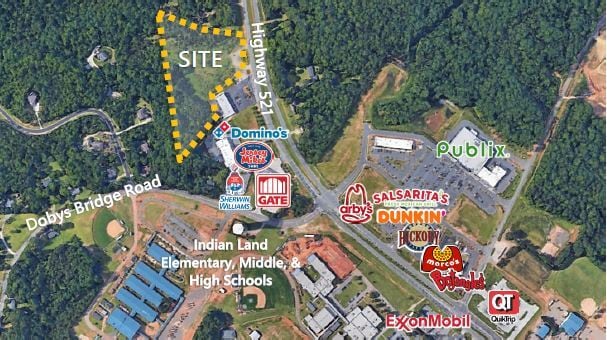
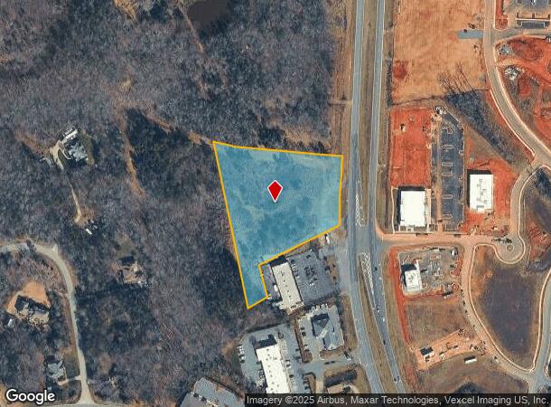
Charlotte Hwy, Fort Mill, SC 29707

NEARBY LISTINGS FOR SALE OR LEASE
Property Detail
Charlotte Hwy
0013-00-011.00
Boundary Survey Of The Property Of Don J
Vacantlandnec
Lancaster
X
South Carolina
45057C0078E
3.65 AC
2024
Lancaster County
2024
Charlotte
011205
Charlotte-Concord-Gastonia, NC-SC
DEMOGRAPHICS near Charlotte Hwy
1 Mile
3 Mile
5 Mile
2024 Total Population
3,094
30,212
88,423
2029 Population
3,723
36,186
102,889
Pop Growth 2024-2029
+ 20.33%
+ 19.77%
+ 16.36%
Average Age
45
44
40
2024 Total Households
1,402
11,950
31,689
HH Growth 2024-2029
+ 20.19%
+ 20.08%
+ 16.94%
Median Household Inc
$66,130
$104,572
$117,829
Avg Household Size
2.20
2.50
2.80
2024 Avg HH Vehicles
2.00
2.00
2.00
Median Home Value
$269,552
$386,726
$396,378
Median Year Built
2007
2010
2009
Nearby Places
- Restaurants
- Banks
- Shops
- Fitness
- Groceries
PUBLIC TRANSPORTATION
AIRPORT
Charlotte/Douglas International
DRIVE
WALK
Distance
Charlotte/Douglas International
36 min
21.4 mi
Concord-Padgett Regional
DRIVE
WALK
Distance
Concord-Padgett Regional
55 min
42.6 mi
SALE & LEASE HISTORY
LISTING DATE
SALE/LEASE

Sep 30, 2016
For Sale
Apr 26, 2019
For Sale
Nearby Properties
Address
Land Use
TOTAL SIZE
Lot Size
Zoning
Address
Land Use
TOTAL SIZE
Lot Size
Zoning
149,109 SF
21.87 AC
INS
Address
Land Use
TOTAL SIZE
Lot Size
Zoning
50,462 SF
15.68 AC
Address
Land Use
TOTAL SIZE
Lot Size
Zoning
95,726 SF
49.65 AC
INS
Address
Land Use
TOTAL SIZE
Lot Size
Zoning
40,516 SF
55.66 AC
INS
Address
Land Use
TOTAL SIZE
Lot Size
Zoning
2.65 AC
R-40 MARVI
Address
Land Use
TOTAL SIZE
Lot Size
Zoning
3.21 AC
R-40 MARVI
Address
Land Use
TOTAL SIZE
Lot Size
Zoning
83.98 AC
GB
Address
Land Use
TOTAL SIZE
Lot Size
Zoning
1,724 SF
43.33 AC
INS
Address
Land Use
TOTAL SIZE
Lot Size
Zoning
2.30 AC
R-40 MARVI
Address
Land Use
TOTAL SIZE
Lot Size
Zoning
1,184 SF
38.39 AC
Address
Land Use
TOTAL SIZE
Lot Size
Zoning
35,779 SF
12.77 AC
INS
Address
Land Use
TOTAL SIZE
Lot Size
Zoning
15,440 SF
2.62 AC
INS
Address
Land Use
TOTAL SIZE
Lot Size
Zoning
4,398 SF
15.25 AC
Address
Land Use
TOTAL SIZE
Lot Size
Zoning
467.55 AC
RUD
Address
Land Use
TOTAL SIZE
Lot Size
Zoning
6,323 SF
20.89 AC
Address
Land Use
TOTAL SIZE
Lot Size
Zoning
7,258 SF
19 AC
PDD
Address
Land Use
TOTAL SIZE
Lot Size
Zoning
10,620 SF
2.68 AC
INS
Address
Land Use
TOTAL SIZE
Lot Size
Zoning
21.35 AC
MX
Address
Land Use
TOTAL SIZE
Lot Size
Zoning
6,494 SF
19.99 AC
PDD
Address
Land Use
TOTAL SIZE
Lot Size
Zoning
2,244 SF
6.90 AC
INS
Address
Land Use
TOTAL SIZE
Lot Size
Zoning
15,486 SF
3 AC
INS
Address
Land Use
TOTAL SIZE
Lot Size
Zoning
0.65 AC
R-40 UNION
Address
Land Use
TOTAL SIZE
Lot Size
Zoning
65 AC
INS
Address
Land Use
TOTAL SIZE
Lot Size
Zoning
0.70 AC
R-40 UNION
Address
Land Use
TOTAL SIZE
Lot Size
Zoning
282.58 AC
RUD
Address
Land Use
TOTAL SIZE
Lot Size
Zoning
0.93 AC
R-40 UNION
Address
Land Use
TOTAL SIZE
Lot Size
Zoning
8,895 SF
13.02 AC
LDR
Address
Land Use
TOTAL SIZE
Lot Size
Zoning
10,275 SF
2 AC
INS
Address
Land Use
TOTAL SIZE
Lot Size
Zoning
4,500 SF
15 AC
INS
Address
Land Use
TOTAL SIZE
Lot Size
Zoning
0.74 AC
R-40 UNION
The World's #1 Commercial Real Estate Marketplace
Connect with us
© 2025 CoStar Group
The information above has been obtained from sources believed reliable. While we do not doubt its accuracy we have not verified it and make no guarantee, warranty or representation about it. It is your responsibility to independently confirm its accuracy and completeness. Any projections, opinions, assumptions, or estimates used are for example only and do not represent the current or future performance of the property. The value of this transaction to you depends on tax and other factors which should be evaluated by your tax, financial, and legal advisors. You and your advisors should conduct a careful, independent investigation of the property to determine to your satisfaction the suitability of the property for your needs.