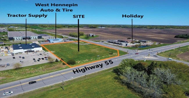
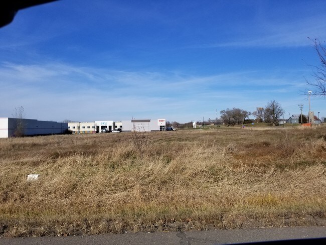
Property Record
65 Address Unassigned, Rockford, MN 55373

NEARBY LISTINGS FOR SALE OR LEASE
Property Detail
65 Address Unassigned
Minneapolis-St. Paul-Bloomington, MN-WI
Greenfield Park 3Rd Addn
28-119-24-34-0014
LOT 001 BLOCK 002 A GREENFIELD PARK 3RD ADDN THAT PART OF LOT 1, BLOCK 2, GREENFIELD PARK THIRD ADDITION DESCRIBED AS FOLLOWS: COMMENCING AT THE NORTHEAST CORNER OF SAID LOT 1; T IRREGULAR
Commercialacreage
Hennepin
X
Minnesota
27053C0129F
1
2024
1.65 AC
2024
Northwest
027001
Minneapolis/St Paul
DEMOGRAPHICS near 65 Address Unassigned
1 Mile
3 Mile
5 Mile
2024 Total Population
954
8,126
18,201
2029 Population
969
8,712
19,418
Pop Growth 2024-2029
+ 1.57%
+ 7.21%
+ 6.69%
Average Age
40
40
41
2024 Total Households
372
3,069
6,724
HH Growth 2024-2029
+ 1.88%
+ 7.43%
+ 6.92%
Median Household Inc
$88,701
$97,807
$104,401
Avg Household Size
2.60
2.70
2.70
2024 Avg HH Vehicles
2.00
2.00
2.00
Median Home Value
$356,249
$317,252
$356,008
Median Year Built
1976
1993
1991
Nearby Places
- Restaurants
- Banks
- Shops
- Fitness
- Groceries
PUBLIC TRANSPORTATION
AIRPORT
Minneapolis-St Paul International/Wold-Chamberlain
DRIVE
WALK
Distance
Minneapolis-St Paul International/Wold-Chamberlain
53 min
36.7 mi
Freight Ports
Port Milwaukee
DRIVE
WALK
Distance
Port Milwaukee
413 min
367.0 mi
SALE & LEASE HISTORY
LISTING DATE
SALE/LEASE

Nov 20, 2018
For Sale
Nov 18, 2019
For Sale
Nearby Properties
Address
Land Use
TOTAL SIZE
Lot Size
Zoning
Address
Land Use
TOTAL SIZE
Lot Size
Zoning
4,416 SF
77.41 AC
Address
Land Use
TOTAL SIZE
Lot Size
Zoning
17.68 AC
Address
Land Use
TOTAL SIZE
Lot Size
Zoning
156,250 SF
24.54 AC
Address
Land Use
TOTAL SIZE
Lot Size
Zoning
87,858 SF
30.54 AC
Address
Land Use
TOTAL SIZE
Lot Size
Zoning
Address
Land Use
TOTAL SIZE
Lot Size
Zoning
71,766 SF
12 AC
Address
Land Use
TOTAL SIZE
Lot Size
Zoning
3,850 SF
6.23 AC
Address
Land Use
TOTAL SIZE
Lot Size
Zoning
6.13 AC
Address
Land Use
TOTAL SIZE
Lot Size
Zoning
50,476 SF
5.41 AC
Address
Land Use
TOTAL SIZE
Lot Size
Zoning
4,035 SF
4.86 AC
Address
Land Use
TOTAL SIZE
Lot Size
Zoning
12,248 SF
2.50 AC
Address
Land Use
TOTAL SIZE
Lot Size
Zoning
12,206 SF
2.32 AC
Address
Land Use
TOTAL SIZE
Lot Size
Zoning
4.55 AC
Address
Land Use
TOTAL SIZE
Lot Size
Zoning
9,120 SF
2.13 AC
Address
Land Use
TOTAL SIZE
Lot Size
Zoning
23,880 SF
0.70 AC
Address
Land Use
TOTAL SIZE
Lot Size
Zoning
25,008 SF
1.51 AC
Address
Land Use
TOTAL SIZE
Lot Size
Zoning
6.41 AC
Address
Land Use
TOTAL SIZE
Lot Size
Zoning
12,384 SF
14.77 AC
Address
Land Use
TOTAL SIZE
Lot Size
Zoning
2.63 AC
Address
Land Use
TOTAL SIZE
Lot Size
Zoning
9,807 SF
2 AC
Address
Land Use
TOTAL SIZE
Lot Size
Zoning
46,659 SF
7.50 AC
Address
Land Use
TOTAL SIZE
Lot Size
Zoning
19,640 SF
1.24 AC
Address
Land Use
TOTAL SIZE
Lot Size
Zoning
20,403 SF
1.10 AC
Address
Land Use
TOTAL SIZE
Lot Size
Zoning
Address
Land Use
TOTAL SIZE
Lot Size
Zoning
4.17 AC
Address
Land Use
TOTAL SIZE
Lot Size
Zoning
16,395 SF
2.95 AC
Address
Land Use
TOTAL SIZE
Lot Size
Zoning
4,016 SF
2.79 AC
Address
Land Use
TOTAL SIZE
Lot Size
Zoning
Address
Land Use
TOTAL SIZE
Lot Size
Zoning
The World's #1 Commercial Real Estate Marketplace
Connect with us
© 2025 CoStar Group
The information above has been obtained from sources believed reliable. While we do not doubt its accuracy we have not verified it and make no guarantee, warranty or representation about it. It is your responsibility to independently confirm its accuracy and completeness. Any projections, opinions, assumptions, or estimates used are for example only and do not represent the current or future performance of the property. The value of this transaction to you depends on tax and other factors which should be evaluated by your tax, financial, and legal advisors. You and your advisors should conduct a careful, independent investigation of the property to determine to your satisfaction the suitability of the property for your needs.