Property Record
0 Highway 6 S, Houston, TX 77079
This Property Is For Sale
NEARBY LISTINGS FOR SALE OR LEASE
Property Detail
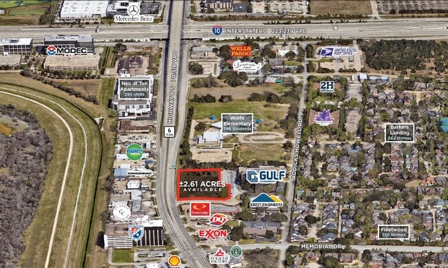
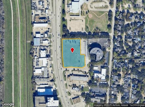
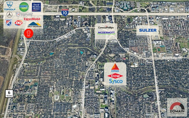
0 Highway 6 S
Houston-The Woodlands-Sugar Land, TX
Barkers Landing Office Park
1142980010001
RES A BARKERS LANDING OFFICE PARK
Commercialacreage
Harris
X
Texas
48201C0620M
2.62 AC
2023
Katy Freeway West
2025
Houston
450302
DEMOGRAPHICS near 0 Highway 6 S
1 Mile
3 Mile
5 Mile
2024 Total Population
8,634
69,763
251,884
2029 Population
8,802
71,396
257,108
Pop Growth 2024-2029
+ 1.95%
+ 2.34%
+ 2.07%
Average Age
40
37
37
2024 Total Households
3,777
30,299
98,450
HH Growth 2024-2029
+ 1.85%
+ 2.17%
+ 2.08%
Median Household Inc
$84,779
$68,981
$66,886
Avg Household Size
2.10
2.20
2.50
2024 Avg HH Vehicles
2.00
2.00
2.00
Median Home Value
$430,708
$389,388
$290,379
Median Year Built
1995
1993
1988
Nearby Places
- Restaurants
- Banks
- Shops
- Fitness
- Groceries
PUBLIC TRANSPORTATION
AIRPORT
William P Hobby
DRIVE
WALK
Distance
William P Hobby
47 min
30.9 mi
George Bush Intcntl/Houston
DRIVE
WALK
Distance
George Bush Intcntl/Houston
42 min
32.2 mi
Freight Ports
Port of Houston
DRIVE
WALK
Distance
Port of Houston
41 min
27.7 mi
Nearby Properties
Address
Land Use
TOTAL SIZE
Lot Size
Zoning
Address
Land Use
TOTAL SIZE
Lot Size
Zoning
2,976,779 SF
41.36 AC
Address
Land Use
TOTAL SIZE
Lot Size
Zoning
1,385,616 SF
6.48 AC
Address
Land Use
TOTAL SIZE
Lot Size
Zoning
1,131,022 SF
6.26 AC
Address
Land Use
TOTAL SIZE
Lot Size
Zoning
1,208,144 SF
6.15 AC
Address
Land Use
TOTAL SIZE
Lot Size
Zoning
759,908 SF
4.54 AC
Address
Land Use
TOTAL SIZE
Lot Size
Zoning
953,143 SF
63.82 AC
Address
Land Use
TOTAL SIZE
Lot Size
Zoning
1,543,856 SF
10.03 AC
Address
Land Use
TOTAL SIZE
Lot Size
Zoning
764,429 SF
6.78 AC
Address
Land Use
TOTAL SIZE
Lot Size
Zoning
1,045,896 SF
11.14 AC
Address
Land Use
TOTAL SIZE
Lot Size
Zoning
690,519 SF
26.57 AC
Address
Land Use
TOTAL SIZE
Lot Size
Zoning
617,832 SF
9.24 AC
Address
Land Use
TOTAL SIZE
Lot Size
Zoning
422,801 SF
12.71 AC
Address
Land Use
TOTAL SIZE
Lot Size
Zoning
520,277 SF
10.04 AC
Address
Land Use
TOTAL SIZE
Lot Size
Zoning
601,167 SF
14.93 AC
Address
Land Use
TOTAL SIZE
Lot Size
Zoning
845,902 SF
16.27 AC
Address
Land Use
TOTAL SIZE
Lot Size
Zoning
451,973 SF
19.47 AC
Address
Land Use
TOTAL SIZE
Lot Size
Zoning
672,183 SF
8.80 AC
Address
Land Use
TOTAL SIZE
Lot Size
Zoning
803,103 SF
5.78 AC
Address
Land Use
TOTAL SIZE
Lot Size
Zoning
638,248 SF
23.38 AC
Address
Land Use
TOTAL SIZE
Lot Size
Zoning
910,592 SF
6.35 AC
Address
Land Use
TOTAL SIZE
Lot Size
Zoning
775,560 SF
7.96 AC
Address
Land Use
TOTAL SIZE
Lot Size
Zoning
487,054 SF
13.85 AC
Address
Land Use
TOTAL SIZE
Lot Size
Zoning
403,650 SF
20.19 AC
Address
Land Use
TOTAL SIZE
Lot Size
Zoning
709,724 SF
6.17 AC
Address
Land Use
TOTAL SIZE
Lot Size
Zoning
488,573 SF
20.57 AC
Address
Land Use
TOTAL SIZE
Lot Size
Zoning
499,216 SF
6.30 AC
Address
Land Use
TOTAL SIZE
Lot Size
Zoning
490,046 SF
4.59 AC
Address
Land Use
TOTAL SIZE
Lot Size
Zoning
682,312 SF
4.67 AC
Address
Land Use
TOTAL SIZE
Lot Size
Zoning
511,135 SF
10.45 AC
Address
Land Use
TOTAL SIZE
Lot Size
Zoning
604,254 SF
4.38 AC
The World's #1 Commercial Real Estate Marketplace
Connect with us
© 2025 CoStar Group
The information above has been obtained from sources believed reliable. While we do not doubt its accuracy we have not verified it and make no guarantee, warranty or representation about it. It is your responsibility to independently confirm its accuracy and completeness. Any projections, opinions, assumptions, or estimates used are for example only and do not represent the current or future performance of the property. The value of this transaction to you depends on tax and other factors which should be evaluated by your tax, financial, and legal advisors. You and your advisors should conduct a careful, independent investigation of the property to determine to your satisfaction the suitability of the property for your needs.