Property Record
Highway 6, Sugar Land, TX 77498
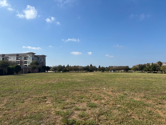
This Property Is For Sale
NEARBY LISTINGS FOR SALE OR LEASE
Property Detail
Highway 6
Houston-Pasadena-The Woodlands, TX
A Hodge
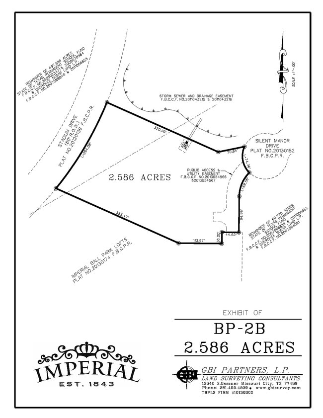
0032-00-000-2050-907
0032 A HODGE, BLOCK 1, ACRES 0.0461, BAXI PLAZA, RESTRICTED RESERVE A (COMMERCIAL), PART
Residentialacreage
Fort Bend
X
Texas
48157C0260L
2.54 AC
0
E Fort Bend Co/Sugar Land
2025
Houston
672100
DEMOGRAPHICS near Highway 6
1 Mile
3 Mile
5 Mile
2024 Total Population
5,504
84,635
282,468
2029 Population
6,678
101,118
328,104
Pop Growth 2024-2029
+ 21.33%
+ 19.48%
+ 16.16%
Average Age
44
40
39
2024 Total Households
2,223
28,583
91,852
HH Growth 2024-2029
+ 21.86%
+ 20.09%
+ 16.83%
Median Household Inc
$110,975
$93,902
$82,758
Avg Household Size
2.40
2.90
3.00
2024 Avg HH Vehicles
2.00
2.00
2.00
Median Home Value
$467,299
$330,529
$293,289
Median Year Built
2010
1996
1993
Nearby Places
Map Layers
Map Styles
 Street
 Aerial
- Restaurants
- Banks
- Shops
- Fitness
- Groceries
PUBLIC TRANSPORTATION
AIRPORT
William P Hobby
DRIVE
WALK
Distance
William P Hobby
42 min
26.3 mi
George Bush Intcntl/Houston
DRIVE
WALK
Distance
George Bush Intcntl/Houston
53 min
42.4 mi
Freight Ports
Port of Houston
DRIVE
WALK
Distance
Port of Houston
43 min
28.4 mi
Nearby Properties
Address
Land Use
TOTAL SIZE
Lot Size
Zoning
Address
Land Use
TOTAL SIZE
Lot Size
Zoning
448,502 SF
35.66 AC
Address
Land Use
TOTAL SIZE
Lot Size
Zoning
171,425 SF
29.96 AC
Address
Land Use
TOTAL SIZE
Lot Size
Zoning
221,618 SF
6.50 AC
Address
Land Use
TOTAL SIZE
Lot Size
Zoning
94,547 SF
13.59 AC
Address
Land Use
TOTAL SIZE
Lot Size
Zoning
378,797 SF
10.97 AC
Address
Land Use
TOTAL SIZE
Lot Size
Zoning
Address
Land Use
TOTAL SIZE
Lot Size
Zoning
287,350 SF
59.38 AC
Address
Land Use
TOTAL SIZE
Lot Size
Zoning
77,850 SF
8.53 AC
YQZ
Address
Land Use
TOTAL SIZE
Lot Size
Zoning
104,287 SF
13.56 AC
M
Address
Land Use
TOTAL SIZE
Lot Size
Zoning
88,705 SF
17.04 AC
SY
Address
Land Use
TOTAL SIZE
Lot Size
Zoning
260,269 SF
8.53 AC
Address
Land Use
TOTAL SIZE
Lot Size
Zoning
Address
Land Use
TOTAL SIZE
Lot Size
Zoning
171,800 SF
11.92 AC
Address
Land Use
TOTAL SIZE
Lot Size
Zoning
129,813 SF
8.53 AC
Address
Land Use
TOTAL SIZE
Lot Size
Zoning
343,438 SF
54.92 AC
S
Address
Land Use
TOTAL SIZE
Lot Size
Zoning
61,006 SF
13.16 AC
X
Address
Land Use
TOTAL SIZE
Lot Size
Zoning
89,033 SF
12.46 AC
Address
Land Use
TOTAL SIZE
Lot Size
Zoning
254,210 SF
10.59 AC
JT
Address
Land Use
TOTAL SIZE
Lot Size
Zoning
49,976 SF
0.79 AC
X
Address
Land Use
TOTAL SIZE
Lot Size
Zoning
194,593 SF
2.29 AC
X
Address
Land Use
TOTAL SIZE
Lot Size
Zoning
291,196 SF
30.06 AC
SXY
Address
Land Use
TOTAL SIZE
Lot Size
Zoning
259,117 SF
6.28 AC
YS
Address
Land Use
TOTAL SIZE
Lot Size
Zoning
218,755 SF
19.69 AC
MQY
Address
Land Use
TOTAL SIZE
Lot Size
Zoning
190,152 SF
13.17 AC
I
Address
Land Use
TOTAL SIZE
Lot Size
Zoning
194,211 SF
26.22 AC
Y
Address
Land Use
TOTAL SIZE
Lot Size
Zoning
156,259 SF
9.28 AC
IT
Address
Land Use
TOTAL SIZE
Lot Size
Zoning
226,700 SF
19.14 AC
M
Address
Land Use
TOTAL SIZE
Lot Size
Zoning
85,872 SF
12.65 AC
S
Address
Land Use
TOTAL SIZE
Lot Size
Zoning
172,513 SF
10.26 AC
Y
Address
Land Use
TOTAL SIZE
Lot Size
Zoning
699,266 SF
53.01 AC
The World's #1 Commercial Real Estate Marketplace
Connect with us
© 2026 CoStar Group
The information above has been obtained from sources believed reliable. While we do not doubt its accuracy we have not verified it and make no guarantee, warranty or representation about it. It is your responsibility to independently confirm its accuracy and completeness. Any projections, opinions, assumptions, or estimates used are for example only and do not represent the current or future performance of the property. The value of this transaction to you depends on tax and other factors which should be evaluated by your tax, financial, and legal advisors. You and your advisors should conduct a careful, independent investigation of the property to determine to your satisfaction the suitability of the property for your needs.