Property Record
Rifle Range Rd, Bartow, FL 33830


NEARBY LISTINGS FOR SALE OR LEASE
-
-
View all Bartow listings for sale on LoopNet.com
Property Detail
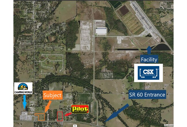
Rifle Range Rd
Lakeland-Winter Haven, FL
Garden Mobile Ranches Blks 1 And 2
26-29-33-000000-034050
THAT PART OF W 995.64 FT OF W1/2 OF NW1/4 N OF HWY 60 & E OF SR 655 LESS N 1960 FT & LESS S 471.8 FT OF W 275 FT THEREOF.
Pasture
Polk
A
Florida
12105C0540G
10.64 AC
2024
Polk County
2025
Tampa/St Petersburg
015200
DEMOGRAPHICS near Rifle Range Rd
1 mile
3 mile
5 mile
2024 Total Population
1,003
8,399
35,795
2029 Population
1,184
9,784
42,636
Pop Growth 2024-2029
+ 18.05%
+ 16.49%
+ 19.11%
Average Age
40
38
40
2024 Total Households
364
2,856
12,841
HH Growth 2024-2029
+ 18.13%
+ 16.49%
+ 19.03%
Median Household Inc
$45,961
$43,014
$53,997
Avg Household Size
2.70
2.90
2.70
2024 Avg HH Vehicles
2.00
2.00
2.00
Median Home Value
$192,045
$181,227
$233,501
Median Year Built
1995
1986
2000
Nearby Places
Map Layers
Map Styles
 Street
 Aerial
Transit
 Traffic
 Biking
Places
Listings with unknown addresses are not visible on the map
- Restaurants
- Banks
- Shops
- Fitness
- Groceries
PUBLIC TRANSPORTATION
COMMUTER RAIL
Winter Haven (Silver Meteor - Amtrak, Silver Star - Amtrak)
Drive
Walk
Distance
Winter Haven (Silver Meteor - Amtrak, Silver Star - Amtrak)
11 min
6.3 mi
Freight Ports
Port of Tampa Bay
Drive
Walk
Distance
Port of Tampa Bay
70 min
47.9 mi
SALE & LEASE HISTORY
LISTING DATE
SALE/LEASE

Mar 28, 2025
For Sale
Nearby Properties
Address
Land Use
TOTAL SIZE
Lot Size
Zoning
Address
Land Use
TOTAL SIZE
Lot Size
Zoning
1,221,145 SF
179.12 AC
Address
Land Use
TOTAL SIZE
Lot Size
Zoning
407,400 SF
22.33 AC
Address
Land Use
TOTAL SIZE
Lot Size
Zoning
332,360 SF
72.50 AC
Address
Land Use
TOTAL SIZE
Lot Size
Zoning
39,428 SF
20.02 AC
Address
Land Use
TOTAL SIZE
Lot Size
Zoning
7,486 SF
61.94 AC
R3
Address
Land Use
TOTAL SIZE
Lot Size
Zoning
29,703 SF
36.18 AC
C4
Address
Land Use
TOTAL SIZE
Lot Size
Zoning
Address
Land Use
TOTAL SIZE
Lot Size
Zoning
66,774 SF
9.20 AC
Address
Land Use
TOTAL SIZE
Lot Size
Zoning
7,794 SF
8.55 AC
Address
Land Use
TOTAL SIZE
Lot Size
Zoning
10,208 SF
191.69 AC
Address
Land Use
TOTAL SIZE
Lot Size
Zoning
81,564 SF
5.91 AC
Address
Land Use
TOTAL SIZE
Lot Size
Zoning
24,149 SF
8.73 AC
Address
Land Use
TOTAL SIZE
Lot Size
Zoning
5,696 SF
2.60 AC
Address
Land Use
TOTAL SIZE
Lot Size
Zoning
134.65 AC
Address
Land Use
TOTAL SIZE
Lot Size
Zoning
8,432 SF
8.09 AC
Address
Land Use
TOTAL SIZE
Lot Size
Zoning
6,970 SF
72.60 AC
Address
Land Use
TOTAL SIZE
Lot Size
Zoning
Address
Land Use
TOTAL SIZE
Lot Size
Zoning
Address
Land Use
TOTAL SIZE
Lot Size
Zoning
8,029 SF
2 AC
Address
Land Use
TOTAL SIZE
Lot Size
Zoning
77.47 AC
Address
Land Use
TOTAL SIZE
Lot Size
Zoning
8,656 SF
1.53 AC
Address
Land Use
TOTAL SIZE
Lot Size
Zoning
23,940 SF
9.51 AC
RE2
Address
Land Use
TOTAL SIZE
Lot Size
Zoning
5,994 SF
9.82 AC
Address
Land Use
TOTAL SIZE
Lot Size
Zoning
5,953 SF
5 AC
Address
Land Use
TOTAL SIZE
Lot Size
Zoning
9,490 SF
3.54 AC
R3
Address
Land Use
TOTAL SIZE
Lot Size
Zoning
5,545 SF
5 AC
Address
Land Use
TOTAL SIZE
Lot Size
Zoning
7,944 SF
1.55 AC
Address
Land Use
TOTAL SIZE
Lot Size
Zoning
8,320 SF
1.03 AC
Address
Land Use
TOTAL SIZE
Lot Size
Zoning
32.03 AC
Address
Land Use
TOTAL SIZE
Lot Size
Zoning
14,000 SF
1.22 AC
The World's #1 Commercial Real Estate Marketplace
Connect with us
© 2026 CoStar Group
The information above has been obtained from sources believed reliable. While we do not doubt its accuracy we have not verified it and make no guarantee, warranty or representation about it. It is your responsibility to independently confirm its accuracy and completeness. Any projections, opinions, assumptions, or estimates used are for example only and do not represent the current or future performance of the property. The value of this transaction to you depends on tax and other factors which should be evaluated by your tax, financial, and legal advisors. You and your advisors should conduct a careful, independent investigation of the property to determine to your satisfaction the suitability of the property for your needs.