Property Record
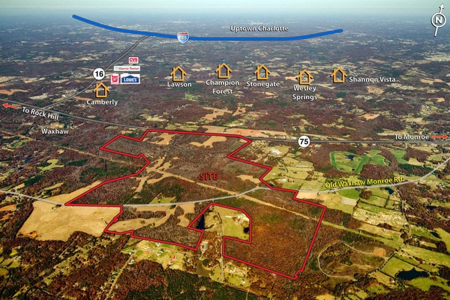
Western Union School Rd, Waxhaw, NC 28173
NEARBY LISTINGS FOR SALE OR LEASE
-
-
View all Waxhaw listings for sale on LoopNet.com
Property Detail
Western Union School Rd
Charlotte-Concord-Gastonia, NC-SC
Monroe Township Farms Llc
05-033-188
TRACT 1 OF 2 8355-085 LESS OPCS176
Agriculturalland
Union
AE
North Carolina
3710449300J
242.89 AC
2025
Union County
2025
Charlotte
021013
DEMOGRAPHICS near Western Union School Rd
1 Mile
3 Mile
5 Mile
2024 Total Population
463
8,971
39,864
2029 Population
529
10,133
45,167
Pop Growth 2024-2029
+ 14.25%
+ 12.95%
+ 13.30%
Average Age
43
41
38
2024 Total Households
172
3,236
12,937
HH Growth 2024-2029
+ 14.53%
+ 13.23%
+ 13.47%
Median Household Inc
$66,600
$84,615
$101,007
Avg Household Size
2.70
2.70
3.00
2024 Avg HH Vehicles
2.00
2.00
2.00
Median Home Value
$336,956
$349,464
$385,568
Median Year Built
1998
1998
2005
Nearby Places
Map Layers
Map Styles
 Street
 Aerial
- Restaurants
- Banks
- Shops
- Fitness
- Groceries
PUBLIC TRANSPORTATION
AIRPORT
Charlotte/Douglas International
DRIVE
WALK
Distance
Charlotte/Douglas International
53 min
34.0 mi
Freight Ports
North Charleston Terminal
DRIVE
WALK
Distance
North Charleston Terminal
221 min
182.4 mi
SALE & LEASE HISTORY
LISTING DATE
SALE/LEASE

Sep 24, 2016
For Sale
Nearby Properties
Address
Land Use
TOTAL SIZE
Lot Size
Zoning
Address
Land Use
TOTAL SIZE
Lot Size
Zoning
53,013 SF
9.32 AC
CD C-4 WAX
Address
Land Use
TOTAL SIZE
Lot Size
Zoning
42,420 SF
6.43 AC
TC WAXHAW
Address
Land Use
TOTAL SIZE
Lot Size
Zoning
57,625 SF
29.09 AC
CU C-2 WAX
Address
Land Use
TOTAL SIZE
Lot Size
Zoning
83,701 SF
33.12 AC
R-2 WAXHAW
Address
Land Use
TOTAL SIZE
Lot Size
Zoning
311.26 AC
AJ7
Address
Land Use
TOTAL SIZE
Lot Size
Zoning
38,347 SF
30 AC
RA-40 MINE
Address
Land Use
TOTAL SIZE
Lot Size
Zoning
24.18 AC
CU C-3 WAX
Address
Land Use
TOTAL SIZE
Lot Size
Zoning
8,280 SF
2.77 AC
C-3 WAXHAW
Address
Land Use
TOTAL SIZE
Lot Size
Zoning
11,301 SF
8.76 AC
R-20 MINER
Address
Land Use
TOTAL SIZE
Lot Size
Zoning
105.86 AC
CU R-3 WAX
Address
Land Use
TOTAL SIZE
Lot Size
Zoning
8.01 AC
C-3 WAXHAW
Address
Land Use
TOTAL SIZE
Lot Size
Zoning
14,420 SF
2.36 AC
NMX WAXHAW
Address
Land Use
TOTAL SIZE
Lot Size
Zoning
16,011 SF
11.67 AC
RA-40 MINE
Address
Land Use
TOTAL SIZE
Lot Size
Zoning
36.82 AC
RA-40 UNIO
Address
Land Use
TOTAL SIZE
Lot Size
Zoning
2,640 SF
37.16 AC
RA-40 UNIO
Address
Land Use
TOTAL SIZE
Lot Size
Zoning
Address
Land Use
TOTAL SIZE
Lot Size
Zoning
10,856 SF
1.28 AC
C-3 WAXHAW
Address
Land Use
TOTAL SIZE
Lot Size
Zoning
24.50 AC
RA-40 UNIO
Address
Land Use
TOTAL SIZE
Lot Size
Zoning
10.20 AC
AR MINERAL
Address
Land Use
TOTAL SIZE
Lot Size
Zoning
7,500 SF
7.63 AC
RA-40 MINE
Address
Land Use
TOTAL SIZE
Lot Size
Zoning
0.84 AC
Address
Land Use
TOTAL SIZE
Lot Size
Zoning
8,655 SF
2.87 AC
TC WAXHAW
Address
Land Use
TOTAL SIZE
Lot Size
Zoning
9,680 SF
0.28 AC
MS WAXHAW
Address
Land Use
TOTAL SIZE
Lot Size
Zoning
10,590 SF
1.78 AC
TC WAXHAW
Address
Land Use
TOTAL SIZE
Lot Size
Zoning
8,400 SF
1.57 AC
C-3 WAXHAW
Address
Land Use
TOTAL SIZE
Lot Size
Zoning
7,932 SF
1.35 AC
C-3 WAXHAW
Address
Land Use
TOTAL SIZE
Lot Size
Zoning
29,948 SF
13.07 AC
UN WAXHAW
Address
Land Use
TOTAL SIZE
Lot Size
Zoning
8,268 SF
21.19 AC
OIS WAXHAW
Address
Land Use
TOTAL SIZE
Lot Size
Zoning
8,700 SF
0.32 AC
MS WAXHAW
The World's #1 Commercial Real Estate Marketplace
Connect with us
© 2026 CoStar Group
The information above has been obtained from sources believed reliable. While we do not doubt its accuracy we have not verified it and make no guarantee, warranty or representation about it. It is your responsibility to independently confirm its accuracy and completeness. Any projections, opinions, assumptions, or estimates used are for example only and do not represent the current or future performance of the property. The value of this transaction to you depends on tax and other factors which should be evaluated by your tax, financial, and legal advisors. You and your advisors should conduct a careful, independent investigation of the property to determine to your satisfaction the suitability of the property for your needs.