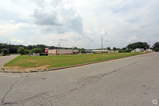
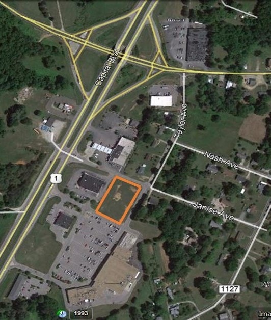
Property Record
591 S Cheatham St, Franklinton, NC 27525
This Property Is For Sale
NEARBY LISTINGS FOR SALE OR LEASE
Property Detail
591 S Cheatham St
Raleigh-Cary, NC
Franklin Acquisitions New Lot
044327
Franklin
Vacantlandnec
North Carolina
AE
c
3720281400K
8.24 AC
2025
Franklin County
2025
Raleigh/Durham
060404
DEMOGRAPHICS near 591 S Cheatham St
1 mile
3 mile
5 mile
2024 Total Population
1,225
11,130
26,763
2029 Population
1,536
13,806
32,741
Pop Growth 2024-2029
+ 25.39%
+ 24.04%
+ 22.34%
Average Age
39
39
40
2024 Total Households
484
4,335
10,198
HH Growth 2024-2029
+ 25.21%
+ 23.97%
+ 22.27%
Median Household Inc
$39,232
$57,218
$67,083
Avg Household Size
2.50
2.50
2.60
2024 Avg HH Vehicles
2.00
2.00
2.00
Median Home Value
$155,999
$222,011
$254,360
Median Year Built
1995
2000
2002
Nearby Places
Map Layers
Map Styles
 Street
 Aerial
Transit
 Traffic
 Biking
Places
Listings with unknown addresses are not visible on the map
- Restaurants
- Banks
- Shops
- Fitness
- Groceries
PUBLIC TRANSPORTATION
AIRPORT
Raleigh-Durham International
Drive
Walk
Distance
Raleigh-Durham International
43 min
30.0 mi
Freight Ports
Virginia Port Authority - Richmond
Drive
Walk
Distance
Virginia Port Authority - Richmond
147 min
124.8 mi
Nearby Properties
Address
Land Use
TOTAL SIZE
Lot Size
Zoning
Address
Land Use
TOTAL SIZE
Lot Size
Zoning
42,428 SF
77.35 AC
FCO R-8
Address
Land Use
TOTAL SIZE
Lot Size
Zoning
20,981 SF
30.74 AC
FCO GB
Address
Land Use
TOTAL SIZE
Lot Size
Zoning
1,900 SF
287 AC
FCO GB
Address
Land Use
TOTAL SIZE
Lot Size
Zoning
63,604 SF
3.49 AC
C-2D
Address
Land Use
TOTAL SIZE
Lot Size
Zoning
3,813 SF
8.58 AC
MUD
Address
Land Use
TOTAL SIZE
Lot Size
Zoning
27,618 SF
10 AC
C-3H
Address
Land Use
TOTAL SIZE
Lot Size
Zoning
1,680 SF
6.20 AC
RSH
Address
Land Use
TOTAL SIZE
Lot Size
Zoning
58,186 SF
63.99 AC
FCO HI
Address
Land Use
TOTAL SIZE
Lot Size
Zoning
1,442 SF
82.75 AC
FCO GB
Address
Land Use
TOTAL SIZE
Lot Size
Zoning
65.20 AC
FCO R-8
Address
Land Use
TOTAL SIZE
Lot Size
Zoning
155.86 AC
FCO HI
Address
Land Use
TOTAL SIZE
Lot Size
Zoning
1,848 SF
310.36 AC
R-1A
Address
Land Use
TOTAL SIZE
Lot Size
Zoning
82.67 AC
LI
Address
Land Use
TOTAL SIZE
Lot Size
Zoning
2,700 SF
313.49 AC
FCO R-8
Address
Land Use
TOTAL SIZE
Lot Size
Zoning
4,271 SF
40.76 AC
C-3H
Address
Land Use
TOTAL SIZE
Lot Size
Zoning
1,012 SF
420 AC
FCO AR
Address
Land Use
TOTAL SIZE
Lot Size
Zoning
12,600 SF
2.34 AC
C 3H
Address
Land Use
TOTAL SIZE
Lot Size
Zoning
10,956 SF
1.49 AC
C-3H
Address
Land Use
TOTAL SIZE
Lot Size
Zoning
82.74 AC
FCO GB
Address
Land Use
TOTAL SIZE
Lot Size
Zoning
7,823 SF
2.17 AC
FCO R-8
Address
Land Use
TOTAL SIZE
Lot Size
Zoning
53.51 AC
G B
Address
Land Use
TOTAL SIZE
Lot Size
Zoning
0.15 AC
LI
Address
Land Use
TOTAL SIZE
Lot Size
Zoning
8,700 SF
1.12 AC
C-3H
Address
Land Use
TOTAL SIZE
Lot Size
Zoning
5,011 SF
7.36 AC
C R I
Address
Land Use
TOTAL SIZE
Lot Size
Zoning
78.03 AC
FCO HI
Address
Land Use
TOTAL SIZE
Lot Size
Zoning
11,002 SF
1.51 AC
C-3H
Address
Land Use
TOTAL SIZE
Lot Size
Zoning
5,857 SF
1.55 AC
C-2D
Address
Land Use
TOTAL SIZE
Lot Size
Zoning
4,464 SF
35.87 AC
PD
Address
Land Use
TOTAL SIZE
Lot Size
Zoning
104.46 AC
PD
Address
Land Use
TOTAL SIZE
Lot Size
Zoning
4,999 SF
6.11 AC
FCO R-8
The World's #1 Commercial Real Estate Marketplace
Connect with us
© 2026 CoStar Group
The information above has been obtained from sources believed reliable. While we do not doubt its accuracy we have not verified it and make no guarantee, warranty or representation about it. It is your responsibility to independently confirm its accuracy and completeness. Any projections, opinions, assumptions, or estimates used are for example only and do not represent the current or future performance of the property. The value of this transaction to you depends on tax and other factors which should be evaluated by your tax, financial, and legal advisors. You and your advisors should conduct a careful, independent investigation of the property to determine to your satisfaction the suitability of the property for your needs.