Property Record
I 10, Hankamer, TX 77560
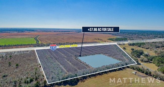


Property Detail
I 10
Houston-Pasadena-The Woodlands, TX
300 TR 8A-1 J T WHITE
00300-00801-00100-120001
CHAMBERS
Agriculturalland
Texas
B and X Area of moderate flood hazard, usually the area between the limits of the 100-year and 500-year floods.
37.86 AC
2025
Outlying Chambers County
2025
Houston
710300
NEARBY LISTINGS FOR SALE OR LEASE
DEMOGRAPHICS near I 10
1 mile
3 mile
5 mile
2025 Total Population
33
817
2,669
2030 Population
37
937
3,099
Pop Growth 2025-2030
+ 12.12%
+ 14.69%
+ 16.11%
Average Age
40
41
42
2025 Total Households
12
307
1,023
HH Growth 2025-2030
+ 16.67%
+ 14.66%
+ 16.32%
Median Household Inc
$112,500
$88,636
$71,999
Avg Household Size
2.30
2.60
2.60
2025 Avg HH Vehicles
3.00
2.00
2.00
Median Home Value
$299,999
$274,999
$277,368
Median Year Built
1984
1985
1989
Nearby Places
Map Layers
Map Styles
 Street
 Aerial
Transit
 Traffic
 Biking
Places
Listings with unknown addresses are not visible on the map
- Restaurants
- Banks
- Shops
- Fitness
- Groceries
SALE & LEASE HISTORY
LISTING DATE
SALE/LEASE

Apr 08, 2025
For Sale
Nearby Properties
Address
Land Use
TOTAL SIZE
Lot Size
Zoning
Address
Land Use
TOTAL SIZE
Lot Size
Zoning
900 SF
20 AC
Address
Land Use
TOTAL SIZE
Lot Size
Zoning
4,729 SF
26.36 AC
Address
Land Use
TOTAL SIZE
Lot Size
Zoning
4,000 SF
7.17 AC
Address
Land Use
TOTAL SIZE
Lot Size
Zoning
4,729 SF
26.36 AC
Address
Land Use
TOTAL SIZE
Lot Size
Zoning
4,941 SF
2.12 AC
Address
Land Use
TOTAL SIZE
Lot Size
Zoning
3,200 SF
2 AC
Address
Land Use
TOTAL SIZE
Lot Size
Zoning
10,473 SF
1.15 AC
Address
Land Use
TOTAL SIZE
Lot Size
Zoning
10,640 SF
0.50 AC
Address
Land Use
TOTAL SIZE
Lot Size
Zoning
2,216 SF
156.09 AC
Address
Land Use
TOTAL SIZE
Lot Size
Zoning
58.14 AC
Address
Land Use
TOTAL SIZE
Lot Size
Zoning
6,800 SF
1 AC
Address
Land Use
TOTAL SIZE
Lot Size
Zoning
3,200 SF
1.22 AC
Address
Land Use
TOTAL SIZE
Lot Size
Zoning
5,000 SF
0.46 AC
Address
Land Use
TOTAL SIZE
Lot Size
Zoning
79.50 AC
Address
Land Use
TOTAL SIZE
Lot Size
Zoning
77.48 AC
Address
Land Use
TOTAL SIZE
Lot Size
Zoning
2,289 SF
0.24 AC
Address
Land Use
TOTAL SIZE
Lot Size
Zoning
2,260 SF
0.27 AC
Address
Land Use
TOTAL SIZE
Lot Size
Zoning
30 AC
Address
Land Use
TOTAL SIZE
Lot Size
Zoning
2,328 SF
0.19 AC
Address
Land Use
TOTAL SIZE
Lot Size
Zoning
2,395 SF
0.24 AC
Address
Land Use
TOTAL SIZE
Lot Size
Zoning
115.90 AC
Address
Land Use
TOTAL SIZE
Lot Size
Zoning
2,144 SF
1.42 AC
Address
Land Use
TOTAL SIZE
Lot Size
Zoning
3,010 SF
1.78 AC
Address
Land Use
TOTAL SIZE
Lot Size
Zoning
2,879 SF
0.33 AC
Address
Land Use
TOTAL SIZE
Lot Size
Zoning
36.92 AC
Address
Land Use
TOTAL SIZE
Lot Size
Zoning
1,827 SF
0.34 AC
Address
Land Use
TOTAL SIZE
Lot Size
Zoning
2,328 SF
0.20 AC
Address
Land Use
TOTAL SIZE
Lot Size
Zoning
2,867 SF
0.32 AC
Address
Land Use
TOTAL SIZE
Lot Size
Zoning
1,929 SF
0.25 AC
The World's #1 Commercial Real Estate Marketplace
Connect with us
© 2026 CoStar Group
The information above has been obtained from sources believed reliable. While we do not doubt its accuracy we have not verified it and make no guarantee, warranty or representation about it. It is your responsibility to independently confirm its accuracy and completeness. Any projections, opinions, assumptions, or estimates used are for example only and do not represent the current or future performance of the property. The value of this transaction to you depends on tax and other factors which should be evaluated by your tax, financial, and legal advisors. You and your advisors should conduct a careful, independent investigation of the property to determine to your satisfaction the suitability of the property for your needs.