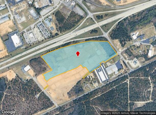
Property Record
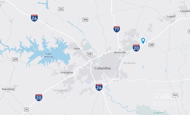
I-20 S S Rd, Columbia, SC 29229

NEARBY LISTINGS FOR SALE OR LEASE
-
-
-
-
-
-
-
No Photo
-
View all Columbia listings for sale on LoopNet.com
Property Detail
I-20 S S Rd
Columbia, SC
TRACT 2 & LOT 3 #SU #PR RB2333-3227 W/S
28800-06-05
Richland
Agriculturalland
South Carolina
X
3
45079C0277L
37.40 AC
2025
Northeast Columbia
2024
Columbia
011417
DEMOGRAPHICS near I-20 S S Rd
1 Mile
3 Mile
5 Mile
2024 Total Population
2,017
19,992
53,958
2029 Population
2,092
20,504
55,057
Pop Growth 2024-2029
+ 3.72%
+ 2.56%
+ 2.04%
Average Age
38
39
39
2024 Total Households
796
7,969
21,167
HH Growth 2024-2029
+ 3.77%
+ 2.60%
+ 2.13%
Median Household Inc
$79,301
$80,825
$72,438
Avg Household Size
2.50
2.50
2.50
2024 Avg HH Vehicles
2.00
2.00
2.00
Median Home Value
$295,412
$298,100
$222,905
Median Year Built
2008
2003
1999
Nearby Places
Map Layers
Map Styles
 Street
 Aerial
- Restaurants
- Banks
- Shops
- Fitness
- Groceries
PUBLIC TRANSPORTATION
AIRPORT
Columbia Metro
DRIVE
WALK
Distance
Columbia Metro
43 min
26.8 mi
Freight Ports
North Charleston Terminal
DRIVE
WALK
Distance
North Charleston Terminal
137 min
120.2 mi
SALE & LEASE HISTORY
LISTING DATE
SALE/LEASE

Sep 24, 2016
For Sale
Oct 28, 2021
For Sale
May 25, 2022
For Sale
Apr 21, 2021
For Sale
Nearby Properties
Address
Land Use
TOTAL SIZE
Lot Size
Zoning
Address
Land Use
TOTAL SIZE
Lot Size
Zoning
298,100 SF
74.42 AC
C-3
Address
Land Use
TOTAL SIZE
Lot Size
Zoning
329,677 SF
17.12 AC
PDD
Address
Land Use
TOTAL SIZE
Lot Size
Zoning
313,664 SF
33.91 AC
RG-2
Address
Land Use
TOTAL SIZE
Lot Size
Zoning
298,080 SF
18.10 AC
RU
Address
Land Use
TOTAL SIZE
Lot Size
Zoning
299,353 SF
12.36 AC
GC
Address
Land Use
TOTAL SIZE
Lot Size
Zoning
210,926 SF
22 AC
HI
Address
Land Use
TOTAL SIZE
Lot Size
Zoning
360,163 SF
20.11 AC
RM-MD
Address
Land Use
TOTAL SIZE
Lot Size
Zoning
245,825 SF
11 AC
RS-2
Address
Land Use
TOTAL SIZE
Lot Size
Zoning
179,808 SF
12.85 AC
RM-HD
Address
Land Use
TOTAL SIZE
Lot Size
Zoning
275,286 SF
15.53 AC
PD
Address
Land Use
TOTAL SIZE
Lot Size
Zoning
31,625 SF
3.30 AC
GC
Address
Land Use
TOTAL SIZE
Lot Size
Zoning
84,860 SF
5.13 AC
PUD-R
Address
Land Use
TOTAL SIZE
Lot Size
Zoning
81,951 SF
11.81 AC
M-1
Address
Land Use
TOTAL SIZE
Lot Size
Zoning
194,728 SF
12.28 AC
RM-MD
Address
Land Use
TOTAL SIZE
Lot Size
Zoning
87,363 SF
10.61 AC
M-1
Address
Land Use
TOTAL SIZE
Lot Size
Zoning
118,547 SF
10.64 AC
GC
Address
Land Use
TOTAL SIZE
Lot Size
Zoning
126,352 SF
10.43 AC
M-1
Address
Land Use
TOTAL SIZE
Lot Size
Zoning
53,984 SF
15 AC
C-3
Address
Land Use
TOTAL SIZE
Lot Size
Zoning
171,876 SF
9.89 AC
RM-HD
Address
Land Use
TOTAL SIZE
Lot Size
Zoning
45,284 SF
4.70 AC
GC
Address
Land Use
TOTAL SIZE
Lot Size
Zoning
8,800 SF
2.12 AC
GC
Address
Land Use
TOTAL SIZE
Lot Size
Zoning
148,156 SF
29.79 AC
PUD-C
Address
Land Use
TOTAL SIZE
Lot Size
Zoning
61,533 SF
6.28 AC
OI
Address
Land Use
TOTAL SIZE
Lot Size
Zoning
49,705 SF
6.50 AC
C-3
Address
Land Use
TOTAL SIZE
Lot Size
Zoning
186,393 SF
13.12 AC
HI
Address
Land Use
TOTAL SIZE
Lot Size
Zoning
55,035 SF
5.47 AC
GC
Address
Land Use
TOTAL SIZE
Lot Size
Zoning
11,550 SF
6.76 AC
HI
Address
Land Use
TOTAL SIZE
Lot Size
Zoning
48,535 SF
2.16 AC
GC
Address
Land Use
TOTAL SIZE
Lot Size
Zoning
56.55 AC
M-1
Address
Land Use
TOTAL SIZE
Lot Size
Zoning
69,000 SF
3.45 AC
C-3
The World's #1 Commercial Real Estate Marketplace
Connect with us
© 2025 CoStar Group
The information above has been obtained from sources believed reliable. While we do not doubt its accuracy we have not verified it and make no guarantee, warranty or representation about it. It is your responsibility to independently confirm its accuracy and completeness. Any projections, opinions, assumptions, or estimates used are for example only and do not represent the current or future performance of the property. The value of this transaction to you depends on tax and other factors which should be evaluated by your tax, financial, and legal advisors. You and your advisors should conduct a careful, independent investigation of the property to determine to your satisfaction the suitability of the property for your needs.