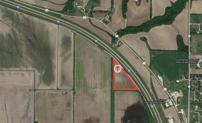
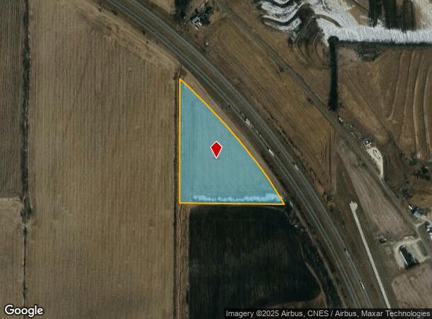
Property Record
I 29, Mound City, MO 64470
NEARBY LISTINGS FOR SALE OR LEASE
-
-
View all Mound City listings for sale on LoopNet.com
Property Detail
I 29
Other Market Areas
25-62-39 SW1/4 SE1/4, LYING SW OF I-29 R/W
08725000008000
Holt
Agriculturalland
Missouri
2025
11.40 AC
2025
Missouri North Area
960200
DEMOGRAPHICS near I 29
1 Mile
3 Mile
5 Mile
2024 Total Population
512
1,280
1,373
2029 Population
511
1,289
1,386
Pop Growth 2024-2029
(0.20%)
+ 0.70%
+ 0.95%
Average Age
46
45
45
2024 Total Households
215
541
582
HH Growth 2024-2029
(0.47%)
+ 0.74%
+ 1.03%
Median Household Inc
$54,091
$55,178
$55,583
Avg Household Size
2.20
2.20
2.20
2024 Avg HH Vehicles
2.00
2.00
2.00
Median Home Value
$94,577
$105,392
$110,177
Median Year Built
1970
1972
1972
Nearby Places
Map Layers
Map Styles
 Street
 Aerial
- Restaurants
- Banks
- Shops
- Fitness
- Groceries
SALE & LEASE HISTORY
LISTING DATE
SALE/LEASE

Nov 09, 2020
For Sale
Nearby Properties
Address
Land Use
TOTAL SIZE
Lot Size
Zoning
Address
Land Use
TOTAL SIZE
Lot Size
Zoning
8.50 AC
Address
Land Use
TOTAL SIZE
Lot Size
Zoning
2,832 SF
0.23 AC
Address
Land Use
TOTAL SIZE
Lot Size
Zoning
3.44 AC
Address
Land Use
TOTAL SIZE
Lot Size
Zoning
71.90 AC
Address
Land Use
TOTAL SIZE
Lot Size
Zoning
0.94 AC
Address
Land Use
TOTAL SIZE
Lot Size
Zoning
1.36 AC
Address
Land Use
TOTAL SIZE
Lot Size
Zoning
2.24 AC
Address
Land Use
TOTAL SIZE
Lot Size
Zoning
4.66 AC
Address
Land Use
TOTAL SIZE
Lot Size
Zoning
1.46 AC
Address
Land Use
TOTAL SIZE
Lot Size
Zoning
0.62 AC
Address
Land Use
TOTAL SIZE
Lot Size
Zoning
Address
Land Use
TOTAL SIZE
Lot Size
Zoning
0.41 AC
Address
Land Use
TOTAL SIZE
Lot Size
Zoning
0.46 AC
Address
Land Use
TOTAL SIZE
Lot Size
Zoning
1.83 AC
Address
Land Use
TOTAL SIZE
Lot Size
Zoning
1.46 AC
Address
Land Use
TOTAL SIZE
Lot Size
Zoning
4.54 AC
Address
Land Use
TOTAL SIZE
Lot Size
Zoning
Address
Land Use
TOTAL SIZE
Lot Size
Zoning
0.41 AC
Address
Land Use
TOTAL SIZE
Lot Size
Zoning
0.29 AC
Address
Land Use
TOTAL SIZE
Lot Size
Zoning
2.16 AC
Address
Land Use
TOTAL SIZE
Lot Size
Zoning
0.52 AC
Address
Land Use
TOTAL SIZE
Lot Size
Zoning
0.50 AC
Address
Land Use
TOTAL SIZE
Lot Size
Zoning
3.05 AC
Address
Land Use
TOTAL SIZE
Lot Size
Zoning
Address
Land Use
TOTAL SIZE
Lot Size
Zoning
5.20 AC
Address
Land Use
TOTAL SIZE
Lot Size
Zoning
0.61 AC
Address
Land Use
TOTAL SIZE
Lot Size
Zoning
Address
Land Use
TOTAL SIZE
Lot Size
Zoning
Address
Land Use
TOTAL SIZE
Lot Size
Zoning
3.21 AC
Address
Land Use
TOTAL SIZE
Lot Size
Zoning
6.51 AC
The World's #1 Commercial Real Estate Marketplace
Connect with us
© 2025 CoStar Group
The information above has been obtained from sources believed reliable. While we do not doubt its accuracy we have not verified it and make no guarantee, warranty or representation about it. It is your responsibility to independently confirm its accuracy and completeness. Any projections, opinions, assumptions, or estimates used are for example only and do not represent the current or future performance of the property. The value of this transaction to you depends on tax and other factors which should be evaluated by your tax, financial, and legal advisors. You and your advisors should conduct a careful, independent investigation of the property to determine to your satisfaction the suitability of the property for your needs.