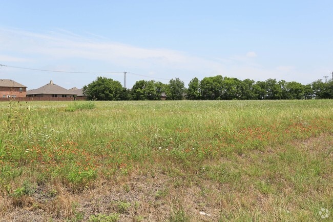
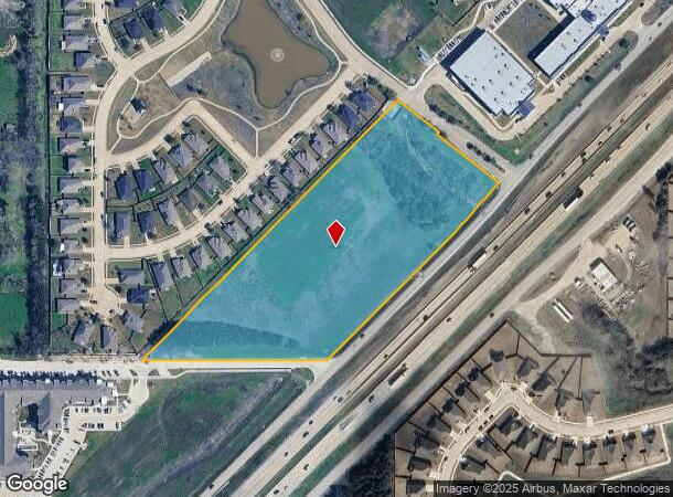
Property Record
5984 E I30, Rockwall, TX 75087
NEARBY LISTINGS FOR SALE OR LEASE
-
-
-
-
-
-
-
-
-
-
-
-
-
-
-
-
-
-
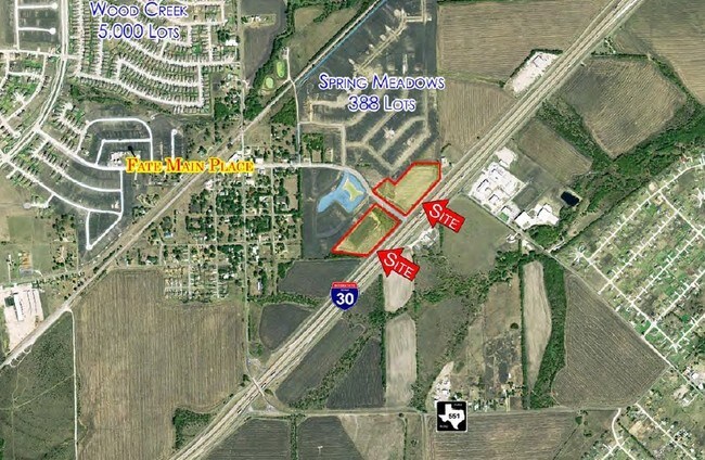
SEC I-30 & FM 549 – Fit Sport Life Development
Rockwall, TX 75087
Rent Upon Request
2.92 AC Lots
Land
-
-
-
-
SEC I-30 & FM 549 – Fit Sport Life Development
Rockwall, TX 75032
Rent Upon Request
11.13 AC Lots
Land
-
-
-
-
View all Rockwall listings for sale on LoopNet.com
Property Detail
5984 E I30
Dallas-Fort Worth-Arlington, TX
S B Crabtree
10509
ABS A0057, S B CRABTREE, TRACT 6-1, 8.09 ACRES
Commercialacreage
Rockwall
A
Texas
48113C0275K
8.09 AC
0
Rockwall
2025
Dallas/Ft Worth
040202
DEMOGRAPHICS near 5984 E I30
1 Mile
3 Mile
5 Mile
2024 Total Population
10,589
34,240
71,586
2029 Population
14,456
47,106
97,704
Pop Growth 2024-2029
+ 36.52%
+ 37.58%
+ 36.48%
Average Age
34
34
36
2024 Total Households
3,271
10,566
23,260
HH Growth 2024-2029
+ 36.75%
+ 37.86%
+ 36.81%
Median Household Inc
$113,692
$109,938
$111,066
Avg Household Size
3.20
3.20
3.00
2024 Avg HH Vehicles
2.00
2.00
2.00
Median Home Value
$270,658
$273,518
$281,398
Median Year Built
2010
2010
2009
Nearby Places
- Restaurants
- Banks
- Shops
- Fitness
- Groceries
PUBLIC TRANSPORTATION
AIRPORT
Dallas Love Field
DRIVE
WALK
Distance
Dallas Love Field
46 min
32.4 mi
Freight Ports
Port of Shreveport
DRIVE
WALK
Distance
Port of Shreveport
209 min
186.5 mi
SALE & LEASE HISTORY
LISTING DATE
SALE/LEASE

Sep 24, 2016
For Sale
Jun 28, 2017
For Sale
Nearby Properties
Address
Land Use
TOTAL SIZE
Lot Size
Zoning
Address
Land Use
TOTAL SIZE
Lot Size
Zoning
408,932 SF
12.93 AC
Address
Land Use
TOTAL SIZE
Lot Size
Zoning
378,763 SF
12.92 AC
Address
Land Use
TOTAL SIZE
Lot Size
Zoning
656,340 SF
34.23 AC
Address
Land Use
TOTAL SIZE
Lot Size
Zoning
569,157 SF
117.09 AC
Address
Land Use
TOTAL SIZE
Lot Size
Zoning
391,599 SF
30.04 AC
Address
Land Use
TOTAL SIZE
Lot Size
Zoning
288,266 SF
38.93 AC
Address
Land Use
TOTAL SIZE
Lot Size
Zoning
83,268 SF
8.67 AC
Address
Land Use
TOTAL SIZE
Lot Size
Zoning
190,558 SF
49.75 AC
Address
Land Use
TOTAL SIZE
Lot Size
Zoning
91,612 SF
14.20 AC
Address
Land Use
TOTAL SIZE
Lot Size
Zoning
80,108 SF
9.92 AC
Address
Land Use
TOTAL SIZE
Lot Size
Zoning
91,039 SF
13.35 AC
Address
Land Use
TOTAL SIZE
Lot Size
Zoning
81,492 SF
11.34 AC
Address
Land Use
TOTAL SIZE
Lot Size
Zoning
66,333 SF
7.46 AC
Address
Land Use
TOTAL SIZE
Lot Size
Zoning
152,669 SF
15.87 AC
Address
Land Use
TOTAL SIZE
Lot Size
Zoning
153,805 SF
13 AC
Address
Land Use
TOTAL SIZE
Lot Size
Zoning
52,582 SF
15.16 AC
Address
Land Use
TOTAL SIZE
Lot Size
Zoning
19,622 SF
1.50 AC
Address
Land Use
TOTAL SIZE
Lot Size
Zoning
114,708 SF
13.83 AC
Address
Land Use
TOTAL SIZE
Lot Size
Zoning
4,343 SF
14.06 AC
Address
Land Use
TOTAL SIZE
Lot Size
Zoning
73,720 SF
5.43 AC
Address
Land Use
TOTAL SIZE
Lot Size
Zoning
396,602 SF
19.74 AC
Address
Land Use
TOTAL SIZE
Lot Size
Zoning
35,488 SF
4.92 AC
Address
Land Use
TOTAL SIZE
Lot Size
Zoning
8,560 SF
7.52 AC
Address
Land Use
TOTAL SIZE
Lot Size
Zoning
38,750 SF
4.21 AC
Address
Land Use
TOTAL SIZE
Lot Size
Zoning
34,468 SF
5.32 AC
Address
Land Use
TOTAL SIZE
Lot Size
Zoning
46,400 SF
6.36 AC
Address
Land Use
TOTAL SIZE
Lot Size
Zoning
25,662 SF
3.13 AC
Address
Land Use
TOTAL SIZE
Lot Size
Zoning
11,392 SF
1.42 AC
The World's #1 Commercial Real Estate Marketplace
Connect with us
© 2025 CoStar Group
The information above has been obtained from sources believed reliable. While we do not doubt its accuracy we have not verified it and make no guarantee, warranty or representation about it. It is your responsibility to independently confirm its accuracy and completeness. Any projections, opinions, assumptions, or estimates used are for example only and do not represent the current or future performance of the property. The value of this transaction to you depends on tax and other factors which should be evaluated by your tax, financial, and legal advisors. You and your advisors should conduct a careful, independent investigation of the property to determine to your satisfaction the suitability of the property for your needs.