Property Record
I-30 S South Opas S, Bryant, AR 72022
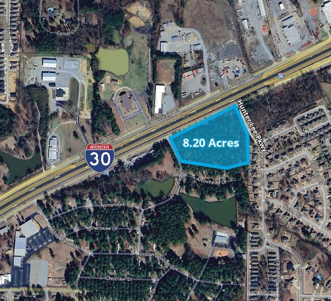
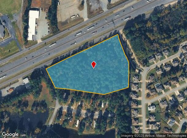

This Property Is For Sale
NEARBY LISTINGS FOR SALE OR LEASE
Property Detail
I-30 S South Opas S
840-12200-005
PT NE1/4-NE1/4, TRACT 1 & 2 2025-003375
Residentialacreage
Saline
X
Arkansas
05125C0240E
8.20 AC
2025
Saline County
2025
Little Rock/N Little Rock
010411
Little Rock-North Little Rock-Conway, AR
DEMOGRAPHICS near I-30 S South Opas S
1 Mile
3 Mile
5 Mile
2024 Total Population
4,343
31,139
60,543
2029 Population
4,680
33,332
63,981
Pop Growth 2024-2029
+ 7.76%
+ 7.04%
+ 5.68%
Average Age
39
38
38
2024 Total Households
1,705
12,061
23,938
HH Growth 2024-2029
+ 8.09%
+ 7.15%
+ 5.61%
Median Household Inc
$78,229
$76,671
$69,437
Avg Household Size
2.50
2.50
2.50
2024 Avg HH Vehicles
2.00
2.00
2.00
Median Home Value
$151,180
$197,630
$201,663
Median Year Built
1997
1999
2000
Nearby Places
Map Layers
Map Styles
 Street
 Aerial
- Restaurants
- Banks
- Shops
- Fitness
- Groceries
PUBLIC TRANSPORTATION
AIRPORT
Bill and Hillary Clinton Ntl/Adams Field
DRIVE
WALK
Distance
Bill and Hillary Clinton Ntl/Adams Field
23 min
17.8 mi
Freight Ports
Port of Shreveport
DRIVE
WALK
Distance
Port of Shreveport
236 min
218.7 mi
Nearby Properties
Address
Land Use
TOTAL SIZE
Lot Size
Zoning
Address
Land Use
TOTAL SIZE
Lot Size
Zoning
80,480 SF
33.40 AC
Address
Land Use
TOTAL SIZE
Lot Size
Zoning
91,459 SF
6.03 AC
Address
Land Use
TOTAL SIZE
Lot Size
Zoning
28,150 SF
17.11 AC
Address
Land Use
TOTAL SIZE
Lot Size
Zoning
304,000 SF
20.93 AC
Address
Land Use
TOTAL SIZE
Lot Size
Zoning
262,431 SF
23.01 AC
Address
Land Use
TOTAL SIZE
Lot Size
Zoning
121,010 SF
13.33 AC
Address
Land Use
TOTAL SIZE
Lot Size
Zoning
174,460 SF
19.30 AC
Address
Land Use
TOTAL SIZE
Lot Size
Zoning
138,752 SF
12.60 AC
Address
Land Use
TOTAL SIZE
Lot Size
Zoning
139,990 SF
14.40 AC
Address
Land Use
TOTAL SIZE
Lot Size
Zoning
19,208 SF
12 AC
Address
Land Use
TOTAL SIZE
Lot Size
Zoning
10,050 SF
94.63 AC
Address
Land Use
TOTAL SIZE
Lot Size
Zoning
36,356 SF
5.45 AC
Address
Land Use
TOTAL SIZE
Lot Size
Zoning
61,535 SF
10.99 AC
Address
Land Use
TOTAL SIZE
Lot Size
Zoning
44,776 SF
7 AC
Address
Land Use
TOTAL SIZE
Lot Size
Zoning
44,132 SF
8.31 AC
Address
Land Use
TOTAL SIZE
Lot Size
Zoning
6,715 SF
2.95 AC
Address
Land Use
TOTAL SIZE
Lot Size
Zoning
49,216 SF
4.30 AC
Address
Land Use
TOTAL SIZE
Lot Size
Zoning
54.01 AC
Address
Land Use
TOTAL SIZE
Lot Size
Zoning
13,612 SF
9.91 AC
Address
Land Use
TOTAL SIZE
Lot Size
Zoning
47,468 SF
1.57 AC
Address
Land Use
TOTAL SIZE
Lot Size
Zoning
75,000 SF
3.70 AC
Address
Land Use
TOTAL SIZE
Lot Size
Zoning
24,000 SF
3.31 AC
Address
Land Use
TOTAL SIZE
Lot Size
Zoning
37,119 SF
2.26 AC
Address
Land Use
TOTAL SIZE
Lot Size
Zoning
46,420 SF
1.50 AC
Address
Land Use
TOTAL SIZE
Lot Size
Zoning
14,668 SF
1.62 AC
Address
Land Use
TOTAL SIZE
Lot Size
Zoning
20,820 SF
2.89 AC
Address
Land Use
TOTAL SIZE
Lot Size
Zoning
44,304 SF
3.40 AC
Address
Land Use
TOTAL SIZE
Lot Size
Zoning
12,341 SF
1.97 AC
Address
Land Use
TOTAL SIZE
Lot Size
Zoning
22,750 SF
2.48 AC
Address
Land Use
TOTAL SIZE
Lot Size
Zoning
45,000 SF
1.46 AC
The World's #1 Commercial Real Estate Marketplace
Connect with us
© 2025 CoStar Group
The information above has been obtained from sources believed reliable. While we do not doubt its accuracy we have not verified it and make no guarantee, warranty or representation about it. It is your responsibility to independently confirm its accuracy and completeness. Any projections, opinions, assumptions, or estimates used are for example only and do not represent the current or future performance of the property. The value of this transaction to you depends on tax and other factors which should be evaluated by your tax, financial, and legal advisors. You and your advisors should conduct a careful, independent investigation of the property to determine to your satisfaction the suitability of the property for your needs.