Property Record
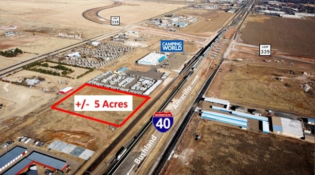
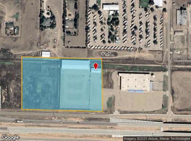
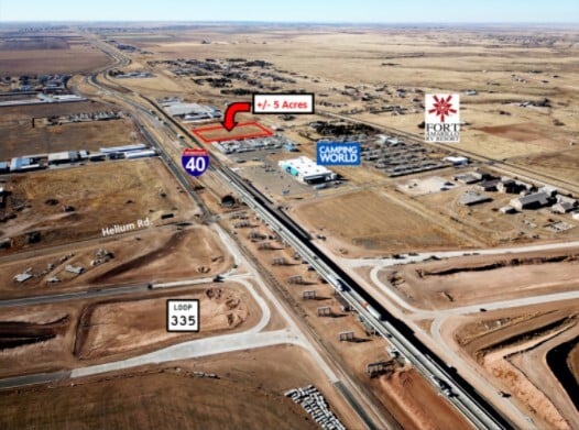
10420 W Interstate 40, Amarillo, TX 79124

NEARBY LISTINGS FOR SALE OR LEASE
Property Detail
10420 W Interstate 40
R-370-0760-1610
B S & F
Warehouse
SECT 76 B S & F BLK 0009, IRREG 10 AC TR BEG APPX 725FT S & 687 FT W OF NE COR OF SECT, 10.0000 ACRES
X
Potter
48375C0504C
Texas
2024
10 AC
2025
Amarillo
014300
Other Market Areas
14,150 SF
Amarillo, TX
DEMOGRAPHICS near 10420 W Interstate 40
1 mile
3 mile
5 mile
2024 Total Population
523
18,071
82,521
2029 Population
546
19,351
87,420
Pop Growth 2024-2029
+ 4.40%
+ 7.08%
+ 5.94%
Average Age
38
41
40
2024 Total Households
176
7,848
34,847
HH Growth 2024-2029
+ 3.98%
+ 6.97%
+ 6.05%
Median Household Inc
$117,424
$69,462
$69,558
Avg Household Size
2.90
2.20
2.30
2024 Avg HH Vehicles
3.00
2.00
2.00
Median Home Value
$295,237
$235,126
$204,022
Median Year Built
2010
1984
1980
Nearby Places
Map Layers
Map Styles
 Street
 Aerial
Transit
 Traffic
 Biking
Places
Listings with unknown addresses are not visible on the map
- Restaurants
- Banks
- Shops
- Fitness
- Groceries
PUBLIC TRANSPORTATION
AIRPORT
Rick Husband Amarillo International
Drive
Walk
Distance
Rick Husband Amarillo International
26 min
17.8 mi
Freight Ports
Tulsa Port Of Catoosa
Drive
Walk
Distance
Tulsa Port Of Catoosa
408 min
385.8 mi
SALE & LEASE HISTORY
LISTING DATE
SALE/LEASE

Jan 27, 2022
For Sale
Nearby Properties
Address
Land Use
TOTAL SIZE
Lot Size
Zoning
Address
Land Use
TOTAL SIZE
Lot Size
Zoning
343,998 SF
19.99 AC
PD
Address
Land Use
TOTAL SIZE
Lot Size
Zoning
1,341,178 SF
16.26 AC
PD2
Address
Land Use
TOTAL SIZE
Lot Size
Zoning
202,800 SF
6.57 AC
Address
Land Use
TOTAL SIZE
Lot Size
Zoning
562,050 SF
9.76 AC
PD
Address
Land Use
TOTAL SIZE
Lot Size
Zoning
129,829 SF
14.50 AC
PD2
Address
Land Use
TOTAL SIZE
Lot Size
Zoning
270,379 SF
12.12 AC
Address
Land Use
TOTAL SIZE
Lot Size
Zoning
485,065 SF
38.89 AC
Address
Land Use
TOTAL SIZE
Lot Size
Zoning
485,065 SF
38.89 AC
Address
Land Use
TOTAL SIZE
Lot Size
Zoning
145,819 SF
12.89 AC
PD
Address
Land Use
TOTAL SIZE
Lot Size
Zoning
52,473 SF
5.67 AC
Address
Land Use
TOTAL SIZE
Lot Size
Zoning
100,099 SF
3 AC
HC
Address
Land Use
TOTAL SIZE
Lot Size
Zoning
327,117 SF
32.06 AC
PD
Address
Land Use
TOTAL SIZE
Lot Size
Zoning
227,707 SF
10.78 AC
GR
Address
Land Use
TOTAL SIZE
Lot Size
Zoning
186,001 SF
2.79 AC
PD
Address
Land Use
TOTAL SIZE
Lot Size
Zoning
186,001 SF
2.79 AC
PD
Address
Land Use
TOTAL SIZE
Lot Size
Zoning
186,001 SF
2.79 AC
PD
Address
Land Use
TOTAL SIZE
Lot Size
Zoning
186,001 SF
2.79 AC
PD
Address
Land Use
TOTAL SIZE
Lot Size
Zoning
54,653 SF
5.45 AC
Address
Land Use
TOTAL SIZE
Lot Size
Zoning
49,647 SF
3.67 AC
Address
Land Use
TOTAL SIZE
Lot Size
Zoning
200,117 SF
7.96 AC
GR
Address
Land Use
TOTAL SIZE
Lot Size
Zoning
89,173 SF
9.55 AC
PD
Address
Land Use
TOTAL SIZE
Lot Size
Zoning
69,009 SF
37.97 AC
Address
Land Use
TOTAL SIZE
Lot Size
Zoning
103,603 SF
10.43 AC
PD2
Address
Land Use
TOTAL SIZE
Lot Size
Zoning
57,725 SF
8.35 AC
GR
Address
Land Use
TOTAL SIZE
Lot Size
Zoning
96,538 SF
11.33 AC
PD
Address
Land Use
TOTAL SIZE
Lot Size
Zoning
207,352 SF
26.15 AC
A
Address
Land Use
TOTAL SIZE
Lot Size
Zoning
204,310 SF
12.50 AC
A
Address
Land Use
TOTAL SIZE
Lot Size
Zoning
49,709 SF
2.71 AC
PD
Address
Land Use
TOTAL SIZE
Lot Size
Zoning
73,558 SF
3.09 AC
The World's #1 Commercial Real Estate Marketplace
Connect with us
© 2026 CoStar Group
The information above has been obtained from sources believed reliable. While we do not doubt its accuracy we have not verified it and make no guarantee, warranty or representation about it. It is your responsibility to independently confirm its accuracy and completeness. Any projections, opinions, assumptions, or estimates used are for example only and do not represent the current or future performance of the property. The value of this transaction to you depends on tax and other factors which should be evaluated by your tax, financial, and legal advisors. You and your advisors should conduct a careful, independent investigation of the property to determine to your satisfaction the suitability of the property for your needs.