Property Record
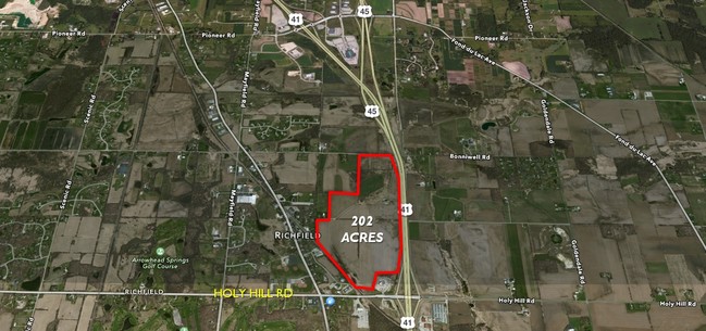
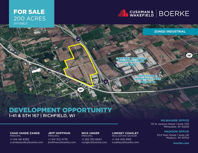
Pleasant Hill Rd, Richfield, WI 53076
This Property Is For Sale
Property Detail
Pleasant Hill Rd
Milwaukee-Waukesha, WI
PT OF NE NE DOC 1308664 SEC 12-9-19 36.75 AC
V10-0249
WASHINGTON
Agriculturalland
Wisconsin
AE The base floodplain where base flood elevations are provided. AE Zones are now used on new format FIRMs instead of A1-A30 Zones.
36.75 AC
2025
Washington East
2025
Milwaukee/Madison
460101
NEARBY LISTINGS FOR SALE OR LEASE
DEMOGRAPHICS near Pleasant Hill Rd
1 mile
3 mile
5 mile
2025 Total Population
804
7,596
29,915
2030 Population
807
7,604
30,143
Pop Growth 2025-2030
+ 0.37%
+ 0.11%
+ 0.76%
Average Age
45
45
44
2025 Total Households
303
2,924
12,326
HH Growth 2025-2030
+ 0.66%
+ 0.07%
+ 0.78%
Median Household Inc
$106,976
$109,766
$104,190
Avg Household Size
2.60
2.60
2.40
2025 Avg HH Vehicles
2.00
2.00
2.00
Median Home Value
$460,897
$439,688
$401,958
Median Year Built
1977
1979
1988
Nearby Places
Map Layers
Map Styles
 Street
 Aerial
Layers
 Traffic
 Biking
Places
Listings with unknown addresses are not visible on the map
- Restaurants
- Banks
- Shops
- Fitness
- Groceries
PUBLIC TRANSPORTATION
AIRPORT
General Mitchell International
Drive
Walk
Distance
General Mitchell International
49 min
33.4 mi
Freight Ports
Port Milwaukee
Drive
Walk
Distance
Port Milwaukee
43 min
29.6 mi
Nearby Properties
Address
Land Use
TOTAL SIZE
Lot Size
Zoning
Address
Land Use
TOTAL SIZE
Lot Size
Zoning
706,000 SF
39.22 AC
Address
Land Use
TOTAL SIZE
Lot Size
Zoning
Address
Land Use
TOTAL SIZE
Lot Size
Zoning
32.89 AC
Address
Land Use
TOTAL SIZE
Lot Size
Zoning
Address
Land Use
TOTAL SIZE
Lot Size
Zoning
240,468 SF
20.03 AC
Address
Land Use
TOTAL SIZE
Lot Size
Zoning
233,282 SF
17.13 AC
Address
Land Use
TOTAL SIZE
Lot Size
Zoning
Address
Land Use
TOTAL SIZE
Lot Size
Zoning
204,373 SF
16.50 AC
Address
Land Use
TOTAL SIZE
Lot Size
Zoning
203,580 SF
13.52 AC
Address
Land Use
TOTAL SIZE
Lot Size
Zoning
198,648 SF
16.57 AC
Address
Land Use
TOTAL SIZE
Lot Size
Zoning
104.57 AC
Address
Land Use
TOTAL SIZE
Lot Size
Zoning
146,022 SF
8.51 AC
Address
Land Use
TOTAL SIZE
Lot Size
Zoning
100,000 SF
13.07 AC
Address
Land Use
TOTAL SIZE
Lot Size
Zoning
28,840 SF
12.02 AC
Address
Land Use
TOTAL SIZE
Lot Size
Zoning
99,710 SF
9.55 AC
Address
Land Use
TOTAL SIZE
Lot Size
Zoning
130,000 SF
12.76 AC
Address
Land Use
TOTAL SIZE
Lot Size
Zoning
10.93 AC
Address
Land Use
TOTAL SIZE
Lot Size
Zoning
5.35 AC
Address
Land Use
TOTAL SIZE
Lot Size
Zoning
10.32 AC
Address
Land Use
TOTAL SIZE
Lot Size
Zoning
18.39 AC
Address
Land Use
TOTAL SIZE
Lot Size
Zoning
18.33 AC
Address
Land Use
TOTAL SIZE
Lot Size
Zoning
14.19 AC
Address
Land Use
TOTAL SIZE
Lot Size
Zoning
Address
Land Use
TOTAL SIZE
Lot Size
Zoning
13.89 AC
Address
Land Use
TOTAL SIZE
Lot Size
Zoning
Address
Land Use
TOTAL SIZE
Lot Size
Zoning
Address
Land Use
TOTAL SIZE
Lot Size
Zoning
Address
Land Use
TOTAL SIZE
Lot Size
Zoning
Address
Land Use
TOTAL SIZE
Lot Size
Zoning
Address
Land Use
TOTAL SIZE
Lot Size
Zoning
2.93 AC
The World's #1 Commercial Real Estate Marketplace
Connect with us
© 2026 CoStar Group
The information above has been obtained from sources believed reliable. While we do not doubt its accuracy we have not verified it and make no guarantee, warranty or representation about it. It is your responsibility to independently confirm its accuracy and completeness. Any projections, opinions, assumptions, or estimates used are for example only and do not represent the current or future performance of the property. The value of this transaction to you depends on tax and other factors which should be evaluated by your tax, financial, and legal advisors. You and your advisors should conduct a careful, independent investigation of the property to determine to your satisfaction the suitability of the property for your needs.