Property Record
33 Love Loop Spur, Richards, TX 77873


NEARBY LISTINGS FOR SALE OR LEASE
Property Detail
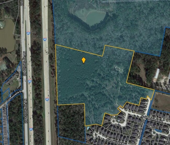
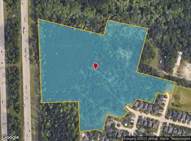
33 Love Loop Spur
Houston-Pasadena-The Woodlands, TX
Cook Francis J
0118-00-00600
A0118 - COOK FRANCIS J, TRACT 6 RESURVEY RD EASEMENT, ACRES 25.274
Timberlandforesttreesagricultural
Montgomery
AE
Texas
48339C0240G
25.27 AC
2024
Conroe
2025
Houston
693800
DEMOGRAPHICS near 33 Love Loop Spur
1 Mile
3 Mile
5 Mile
2024 Total Population
3,502
20,338
73,197
2029 Population
4,324
25,028
90,023
Pop Growth 2024-2029
+ 23.47%
+ 23.06%
+ 22.99%
Average Age
41
39
37
2024 Total Households
1,289
7,199
26,340
HH Growth 2024-2029
+ 23.82%
+ 23.25%
+ 23.75%
Median Household Inc
$65,714
$68,407
$66,350
Avg Household Size
2.70
2.80
2.70
2024 Avg HH Vehicles
2.00
2.00
2.00
Median Home Value
$239,323
$250,713
$252,960
Median Year Built
1991
1999
2002
Nearby Places
Map Layers
Map Styles
 Street
 Aerial
- Restaurants
- Banks
- Shops
- Fitness
- Groceries
PUBLIC TRANSPORTATION
AIRPORT
George Bush Intcntl/Houston
DRIVE
WALK
Distance
George Bush Intcntl/Houston
46 min
37.1 mi
Freight Ports
Port of Houston
DRIVE
WALK
Distance
Port of Houston
69 min
52.8 mi
SALE & LEASE HISTORY
LISTING DATE
SALE/LEASE

Jul 21, 2017
For Sale
Nearby Properties
Address
Land Use
TOTAL SIZE
Lot Size
Zoning
Address
Land Use
TOTAL SIZE
Lot Size
Zoning
776,164 SF
71.74 AC
Address
Land Use
TOTAL SIZE
Lot Size
Zoning
419,016 SF
26 AC
Address
Land Use
TOTAL SIZE
Lot Size
Zoning
308,438 SF
14.35 AC
Address
Land Use
TOTAL SIZE
Lot Size
Zoning
322,588 SF
14.77 AC
Address
Land Use
TOTAL SIZE
Lot Size
Zoning
280,904 SF
12 AC
Address
Land Use
TOTAL SIZE
Lot Size
Zoning
275,000 SF
13.65 AC
Address
Land Use
TOTAL SIZE
Lot Size
Zoning
366,709 SF
27.72 AC
Address
Land Use
TOTAL SIZE
Lot Size
Zoning
206,841 SF
23.44 AC
Address
Land Use
TOTAL SIZE
Lot Size
Zoning
399,360 SF
30 AC
Address
Land Use
TOTAL SIZE
Lot Size
Zoning
141,100 SF
25.34 AC
Address
Land Use
TOTAL SIZE
Lot Size
Zoning
62,296 SF
20.62 AC
Address
Land Use
TOTAL SIZE
Lot Size
Zoning
287,364 SF
23.45 AC
4
Address
Land Use
TOTAL SIZE
Lot Size
Zoning
75,048 SF
10.59 AC
Address
Land Use
TOTAL SIZE
Lot Size
Zoning
214,039 SF
20 AC
Address
Land Use
TOTAL SIZE
Lot Size
Zoning
448,675 SF
52.68 AC
4
Address
Land Use
TOTAL SIZE
Lot Size
Zoning
235,219 SF
40.03 AC
Address
Land Use
TOTAL SIZE
Lot Size
Zoning
332,274 SF
40 AC
Address
Land Use
TOTAL SIZE
Lot Size
Zoning
93,668 SF
45.56 AC
Address
Land Use
TOTAL SIZE
Lot Size
Zoning
87,864 SF
22.43 AC
Address
Land Use
TOTAL SIZE
Lot Size
Zoning
236,986 SF
19.54 AC
Address
Land Use
TOTAL SIZE
Lot Size
Zoning
210,383 SF
15.84 AC
Address
Land Use
TOTAL SIZE
Lot Size
Zoning
251,207 SF
45 AC
Address
Land Use
TOTAL SIZE
Lot Size
Zoning
117,918 SF
13.63 AC
Address
Land Use
TOTAL SIZE
Lot Size
Zoning
188,128 SF
30.49 AC
1
Address
Land Use
TOTAL SIZE
Lot Size
Zoning
115,276 SF
15 AC
Address
Land Use
TOTAL SIZE
Lot Size
Zoning
41,700 SF
24.68 AC
Address
Land Use
TOTAL SIZE
Lot Size
Zoning
102,430 SF
2.54 AC
Address
Land Use
TOTAL SIZE
Lot Size
Zoning
76,800 SF
15.42 AC
The World's #1 Commercial Real Estate Marketplace
Connect with us
© 2026 CoStar Group
The information above has been obtained from sources believed reliable. While we do not doubt its accuracy we have not verified it and make no guarantee, warranty or representation about it. It is your responsibility to independently confirm its accuracy and completeness. Any projections, opinions, assumptions, or estimates used are for example only and do not represent the current or future performance of the property. The value of this transaction to you depends on tax and other factors which should be evaluated by your tax, financial, and legal advisors. You and your advisors should conduct a careful, independent investigation of the property to determine to your satisfaction the suitability of the property for your needs.