Property Record
I-49 Frontage Rd, Sunset, LA 70584
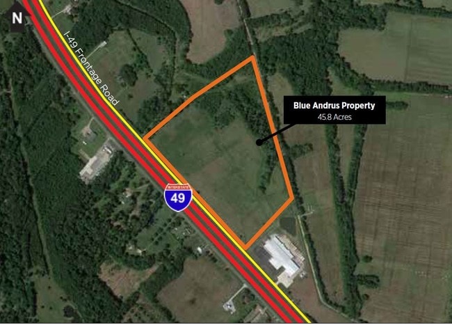
This Property Is For Sale
Property Detail
I-49 Frontage Rd
Opelousas, LA
31.27 AC IN SEC 65 T-7S R-4E 984999 (E-43-400)
0201748100A
ST LANDRY
Residentialacreage
Louisiana
2025
15 AC
2025
Lafayette
9618003020
Other Market Areas
NEARBY LISTINGS FOR SALE OR LEASE
-
-
View all Sunset listings for sale on LoopNet.com
DEMOGRAPHICS near I-49 Frontage Rd
1 mile
3 mile
5 mile
2025 Total Population
437
5,663
15,912
2030 Population
427
5,509
15,606
Pop Growth 2025-2030
(2.29%)
(2.72%)
(1.92%)
Average Age
39
39
40
2025 Total Households
177
2,225
6,169
HH Growth 2025-2030
(2.26%)
(2.88%)
(2.03%)
Median Household Inc
$68,611
$61,244
$58,080
Avg Household Size
2.40
2.50
2.50
2025 Avg HH Vehicles
2.00
2.00
2.00
Median Home Value
$171,052
$171,249
$170,051
Median Year Built
1976
1979
1986
Nearby Places
Map Layers
Map Styles
 Street
 Aerial
Layers
 Traffic
 Biking
Places
Listings with unknown addresses are not visible on the map
- Restaurants
- Banks
- Shops
- Fitness
- Groceries
PUBLIC TRANSPORTATION
AIRPORT
Lafayette Regional/Paul Fournet Field
Drive
Walk
Distance
Lafayette Regional/Paul Fournet Field
25 min
17.1 mi
Freight Ports
Port of Iberia
Drive
Walk
Distance
Port of Iberia
51 min
38.4 mi
Nearby Properties
Address
Land Use
TOTAL SIZE
Lot Size
Zoning
Address
Land Use
TOTAL SIZE
Lot Size
Zoning
6.91 AC
Address
Land Use
TOTAL SIZE
Lot Size
Zoning
Address
Land Use
TOTAL SIZE
Lot Size
Zoning
Address
Land Use
TOTAL SIZE
Lot Size
Zoning
2.90 AC
Address
Land Use
TOTAL SIZE
Lot Size
Zoning
Address
Land Use
TOTAL SIZE
Lot Size
Zoning
Address
Land Use
TOTAL SIZE
Lot Size
Zoning
0.58 AC
Address
Land Use
TOTAL SIZE
Lot Size
Zoning
3.03 AC
Address
Land Use
TOTAL SIZE
Lot Size
Zoning
2.95 AC
Address
Land Use
TOTAL SIZE
Lot Size
Zoning
3.41 AC
Address
Land Use
TOTAL SIZE
Lot Size
Zoning
0.23 AC
Address
Land Use
TOTAL SIZE
Lot Size
Zoning
Address
Land Use
TOTAL SIZE
Lot Size
Zoning
Address
Land Use
TOTAL SIZE
Lot Size
Zoning
1.93 AC
Address
Land Use
TOTAL SIZE
Lot Size
Zoning
Address
Land Use
TOTAL SIZE
Lot Size
Zoning
Address
Land Use
TOTAL SIZE
Lot Size
Zoning
1.51 AC
Address
Land Use
TOTAL SIZE
Lot Size
Zoning
1.64 AC
Address
Land Use
TOTAL SIZE
Lot Size
Zoning
0.97 AC
Address
Land Use
TOTAL SIZE
Lot Size
Zoning
1.03 AC
Address
Land Use
TOTAL SIZE
Lot Size
Zoning
Address
Land Use
TOTAL SIZE
Lot Size
Zoning
0.77 AC
Address
Land Use
TOTAL SIZE
Lot Size
Zoning
Address
Land Use
TOTAL SIZE
Lot Size
Zoning
Address
Land Use
TOTAL SIZE
Lot Size
Zoning
Address
Land Use
TOTAL SIZE
Lot Size
Zoning
Address
Land Use
TOTAL SIZE
Lot Size
Zoning
0.53 AC
Address
Land Use
TOTAL SIZE
Lot Size
Zoning
Address
Land Use
TOTAL SIZE
Lot Size
Zoning
0.88 AC
Address
Land Use
TOTAL SIZE
Lot Size
Zoning
The World's #1 Commercial Real Estate Marketplace
Connect with us
© 2026 CoStar Group
The information above has been obtained from sources believed reliable. While we do not doubt its accuracy we have not verified it and make no guarantee, warranty or representation about it. It is your responsibility to independently confirm its accuracy and completeness. Any projections, opinions, assumptions, or estimates used are for example only and do not represent the current or future performance of the property. The value of this transaction to you depends on tax and other factors which should be evaluated by your tax, financial, and legal advisors. You and your advisors should conduct a careful, independent investigation of the property to determine to your satisfaction the suitability of the property for your needs.