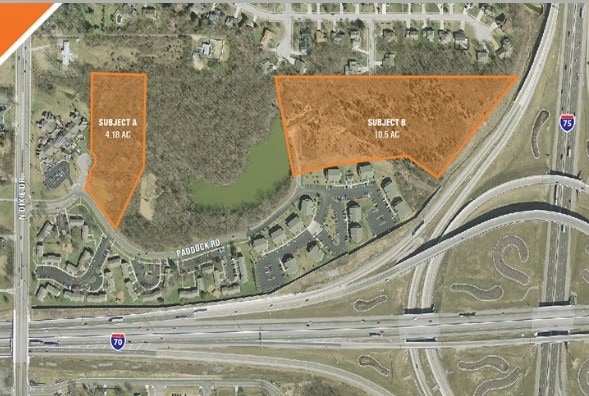
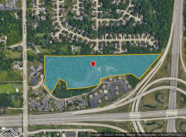
Property Record
Dixie Dr, Vandalia, OH 45377
This Property Is For Sale
NEARBY LISTINGS FOR SALE OR LEASE
Property Detail
Dixie Dr
Dayton, OH
6-3-22
B02-00601-0015
Montgomery
Farms
Ohio
X
15
39113C0152E
25.23 AC
2024
North Dayton
2025
Cincinnati/Dayton
115011
DEMOGRAPHICS near Dixie Dr
1 Mile
3 Mile
5 Mile
2024 Total Population
4,443
26,807
92,290
2029 Population
4,330
26,216
91,110
Pop Growth 2024-2029
(2.54%)
(2.20%)
(1.28%)
Average Age
43
43
41
2024 Total Households
1,879
11,619
38,952
HH Growth 2024-2029
(2.55%)
(2.25%)
(1.37%)
Median Household Inc
$92,093
$70,697
$61,745
Avg Household Size
2.30
2.20
2.30
2024 Avg HH Vehicles
2.00
2.00
2.00
Median Home Value
$229,703
$179,383
$158,994
Median Year Built
1976
1971
1969
Nearby Places
Map Layers
Map Styles
 Street
 Aerial
- Restaurants
- Banks
- Shops
- Fitness
- Groceries
PUBLIC TRANSPORTATION
AIRPORT
James M Cox Dayton International
DRIVE
WALK
Distance
James M Cox Dayton International
12 min
5.1 mi
Freight Ports
Port of Toledo
DRIVE
WALK
Distance
Port of Toledo
171 min
146.1 mi
Nearby Properties
Address
Land Use
TOTAL SIZE
Lot Size
Zoning
Address
Land Use
TOTAL SIZE
Lot Size
Zoning
104,192 SF
923.52 AC
Address
Land Use
TOTAL SIZE
Lot Size
Zoning
340,028 SF
37.51 AC
Address
Land Use
TOTAL SIZE
Lot Size
Zoning
678,154 SF
858.39 AC
Address
Land Use
TOTAL SIZE
Lot Size
Zoning
678,154 SF
1,128.84 AC
Address
Land Use
TOTAL SIZE
Lot Size
Zoning
664,824 SF
1,128.84 AC
Address
Land Use
TOTAL SIZE
Lot Size
Zoning
37.86 AC
Address
Land Use
TOTAL SIZE
Lot Size
Zoning
54,740 SF
8.01 AC
Address
Land Use
TOTAL SIZE
Lot Size
Zoning
730,000 SF
56.40 AC
Address
Land Use
TOTAL SIZE
Lot Size
Zoning
45,980 SF
6.05 AC
Address
Land Use
TOTAL SIZE
Lot Size
Zoning
433,792 SF
34.46 AC
Address
Land Use
TOTAL SIZE
Lot Size
Zoning
425,641 SF
33.79 AC
Address
Land Use
TOTAL SIZE
Lot Size
Zoning
730,000 SF
56.40 AC
Address
Land Use
TOTAL SIZE
Lot Size
Zoning
12,660 SF
20.22 AC
Address
Land Use
TOTAL SIZE
Lot Size
Zoning
505,736 SF
45.42 AC
Address
Land Use
TOTAL SIZE
Lot Size
Zoning
313,421 SF
19.55 AC
Address
Land Use
TOTAL SIZE
Lot Size
Zoning
Address
Land Use
TOTAL SIZE
Lot Size
Zoning
172,753 SF
23.76 AC
Address
Land Use
TOTAL SIZE
Lot Size
Zoning
183,333 SF
5.12 AC
Address
Land Use
TOTAL SIZE
Lot Size
Zoning
10.87 AC
Address
Land Use
TOTAL SIZE
Lot Size
Zoning
220,548 SF
23.11 AC
Address
Land Use
TOTAL SIZE
Lot Size
Zoning
106,375 SF
2.26 AC
Address
Land Use
TOTAL SIZE
Lot Size
Zoning
509,060 SF
31.03 AC
Address
Land Use
TOTAL SIZE
Lot Size
Zoning
239,750 SF
9.12 AC
Address
Land Use
TOTAL SIZE
Lot Size
Zoning
94,671 SF
6.42 AC
Address
Land Use
TOTAL SIZE
Lot Size
Zoning
179,704 SF
18.68 AC
Address
Land Use
TOTAL SIZE
Lot Size
Zoning
193,311 SF
9.37 AC
Address
Land Use
TOTAL SIZE
Lot Size
Zoning
76,156 SF
97.13 AC
Address
Land Use
TOTAL SIZE
Lot Size
Zoning
92,985 SF
14.50 AC
Address
Land Use
TOTAL SIZE
Lot Size
Zoning
92,615 SF
2.68 AC
Address
Land Use
TOTAL SIZE
Lot Size
Zoning
162,286 SF
15.25 AC
The World's #1 Commercial Real Estate Marketplace
Connect with us
© 2026 CoStar Group
The information above has been obtained from sources believed reliable. While we do not doubt its accuracy we have not verified it and make no guarantee, warranty or representation about it. It is your responsibility to independently confirm its accuracy and completeness. Any projections, opinions, assumptions, or estimates used are for example only and do not represent the current or future performance of the property. The value of this transaction to you depends on tax and other factors which should be evaluated by your tax, financial, and legal advisors. You and your advisors should conduct a careful, independent investigation of the property to determine to your satisfaction the suitability of the property for your needs.