Property Record
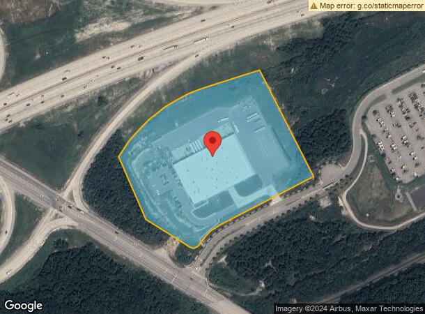
5045 Summit Spring Way, Ooltewah, TN 37363
NEARBY LISTINGS FOR SALE OR LEASE
Property Detail
5045 Summit Spring Way
Chattanooga, TN-GA
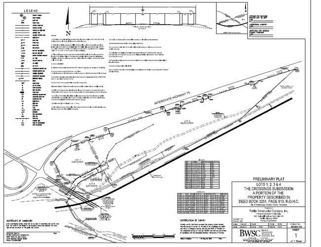
The Crossings Sub
131-099.11
LT 1 THE CROSSINGS SUB PB 107 PG 48 OUT OF 131 099 FOR 2017
Warehouse
Hamilton
X
Tennessee
47065C0378G
1
2025
9.98 AC
2025
Outlying Chattanooga
011311
Chattanooga
64,512 SF
DEMOGRAPHICS near 5045 Summit Spring Way
1 Mile
3 Mile
5 Mile
2024 Total Population
2,051
28,636
82,929
2029 Population
2,268
30,359
88,250
Pop Growth 2024-2029
+ 10.58%
+ 6.02%
+ 6.42%
Average Age
37
42
41
2024 Total Households
742
10,805
32,065
HH Growth 2024-2029
+ 10.38%
+ 6.20%
+ 6.61%
Median Household Inc
$66,961
$75,982
$78,040
Avg Household Size
2.70
2.50
2.40
2024 Avg HH Vehicles
2.00
2.00
2.00
Median Home Value
$200,621
$261,400
$259,457
Median Year Built
1997
1996
1991
Nearby Places
Map Layers
Map Styles
 Street
 Aerial
- Restaurants
- Banks
- Shops
- Fitness
- Groceries
PUBLIC TRANSPORTATION
AIRPORT
Lovell Field
DRIVE
WALK
Distance
Lovell Field
17 min
8.8 mi
Freight Ports
Georgia Ports - Savannah
DRIVE
WALK
Distance
Georgia Ports - Savannah
410 min
365.8 mi
SALE & LEASE HISTORY
LISTING DATE
SALE/LEASE

Dec 30, 2016
For Sale
Apr 23, 2018
For Sale
Nearby Properties
Address
Land Use
TOTAL SIZE
Lot Size
Zoning
Address
Land Use
TOTAL SIZE
Lot Size
Zoning
2,025,141 SF
1,096 AC
M1
Address
Land Use
TOTAL SIZE
Lot Size
Zoning
0.06 AC
M1
Address
Land Use
TOTAL SIZE
Lot Size
Zoning
523,520 SF
12.03 AC
M1
Address
Land Use
TOTAL SIZE
Lot Size
Zoning
213,416 SF
56.75 AC
Address
Land Use
TOTAL SIZE
Lot Size
Zoning
1,015,740 SF
83.82 AC
M1
Address
Land Use
TOTAL SIZE
Lot Size
Zoning
333,801 SF
15.44 AC
C2
Address
Land Use
TOTAL SIZE
Lot Size
Zoning
25,512 SF
21.82 AC
A
Address
Land Use
TOTAL SIZE
Lot Size
Zoning
30,008 SF
20.51 AC
Address
Land Use
TOTAL SIZE
Lot Size
Zoning
242,788 SF
27 AC
Address
Land Use
TOTAL SIZE
Lot Size
Zoning
1,360 SF
20.13 AC
R4
Address
Land Use
TOTAL SIZE
Lot Size
Zoning
287,820 SF
13.33 AC
R3
Address
Land Use
TOTAL SIZE
Lot Size
Zoning
100,606 SF
Address
Land Use
TOTAL SIZE
Lot Size
Zoning
320,068 SF
42.83 AC
R4
Address
Land Use
TOTAL SIZE
Lot Size
Zoning
24,744 SF
16.45 AC
Address
Land Use
TOTAL SIZE
Lot Size
Zoning
21,912 SF
14 AC
A
Address
Land Use
TOTAL SIZE
Lot Size
Zoning
23,078 SF
14.41 AC
R4
Address
Land Use
TOTAL SIZE
Lot Size
Zoning
333,768 SF
15.38 AC
C4
Address
Land Use
TOTAL SIZE
Lot Size
Zoning
218,244 SF
16.33 AC
Address
Land Use
TOTAL SIZE
Lot Size
Zoning
23,124 SF
27.23 AC
A
Address
Land Use
TOTAL SIZE
Lot Size
Zoning
102,382 SF
29.80 AC
M2
Address
Land Use
TOTAL SIZE
Lot Size
Zoning
237,764 SF
60.56 AC
Address
Land Use
TOTAL SIZE
Lot Size
Zoning
60,561 SF
M2
Address
Land Use
TOTAL SIZE
Lot Size
Zoning
82,000 SF
22.45 AC
M1
Address
Land Use
TOTAL SIZE
Lot Size
Zoning
201,276 SF
15.30 AC
R3
Address
Land Use
TOTAL SIZE
Lot Size
Zoning
49,857 SF
1.93 AC
R1
Address
Land Use
TOTAL SIZE
Lot Size
Zoning
59,594 SF
7.61 AC
A
Address
Land Use
TOTAL SIZE
Lot Size
Zoning
17,800 SF
14.30 AC
R2
Address
Land Use
TOTAL SIZE
Lot Size
Zoning
1,024 AC
Address
Land Use
TOTAL SIZE
Lot Size
Zoning
181,036 SF
6.27 AC
R3
Address
Land Use
TOTAL SIZE
Lot Size
Zoning
156,170 SF
6.40 AC
M1
The World's #1 Commercial Real Estate Marketplace
Connect with us
© 2026 CoStar Group
The information above has been obtained from sources believed reliable. While we do not doubt its accuracy we have not verified it and make no guarantee, warranty or representation about it. It is your responsibility to independently confirm its accuracy and completeness. Any projections, opinions, assumptions, or estimates used are for example only and do not represent the current or future performance of the property. The value of this transaction to you depends on tax and other factors which should be evaluated by your tax, financial, and legal advisors. You and your advisors should conduct a careful, independent investigation of the property to determine to your satisfaction the suitability of the property for your needs.