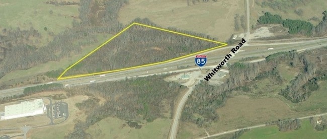
Property Record
I 85, , GA

Save to a Folder
{{folder.Name}}
{{folder.ListingIds.length}} Properties
{{folder.ListingIds.length}} Property
Create a New Folder
Property Detail
I 85
C12-001
GMD 1117
Residentialacreage
HART
D
Georgia
B and X Area of moderate flood hazard, usually the area between the limits of the 100-year and 500-year floods.
13.20 AC
2025
Georgia Northeast
2025
Other Market Areas
9603001110
NEARBY LISTINGS FOR SALE OR LEASE
-
-
View all listings for sale on LoopNet.com
DEMOGRAPHICS near I 85
1 mile
3 mile
5 mile
2025 Total Population
267
4,604
12,249
2030 Population
298
5,046
13,324
Pop Growth 2025-2030
+ 11.61%
+ 9.60%
+ 8.78%
Average Age
46
45
44
2025 Total Households
112
1,927
5,112
HH Growth 2025-2030
+ 11.61%
+ 9.60%
+ 8.86%
Median Household Inc
$56,249
$62,458
$63,465
Avg Household Size
2.30
2.40
2.40
2025 Avg HH Vehicles
2.00
2.00
2.00
Median Home Value
$284,090
$280,307
$275,356
Median Year Built
1983
1990
1991
Nearby Places
Map Layers
Map Styles
 Street
 Aerial
Layers
 Traffic
 Biking
Places
Listings with unknown addresses are not visible on the map
- Restaurants
- Banks
- Shops
- Fitness
- Groceries
SALE & LEASE HISTORY
LISTING DATE
SALE/LEASE

Oct 05, 2018
For Sale
Nearby Properties
Address
Land Use
TOTAL SIZE
Lot Size
Zoning
Address
Land Use
TOTAL SIZE
Lot Size
Zoning
294,244 SF
29.68 AC
Address
Land Use
TOTAL SIZE
Lot Size
Zoning
115,107 SF
25 AC
Address
Land Use
TOTAL SIZE
Lot Size
Zoning
8,364 SF
28.91 AC
Address
Land Use
TOTAL SIZE
Lot Size
Zoning
143,910 SF
15.04 AC
Address
Land Use
TOTAL SIZE
Lot Size
Zoning
27,560 SF
10 AC
Address
Land Use
TOTAL SIZE
Lot Size
Zoning
121.20 AC
Address
Land Use
TOTAL SIZE
Lot Size
Zoning
143,910 SF
23.59 AC
Address
Land Use
TOTAL SIZE
Lot Size
Zoning
4,296 SF
3.28 AC
Address
Land Use
TOTAL SIZE
Lot Size
Zoning
2,623 SF
22.25 AC
Address
Land Use
TOTAL SIZE
Lot Size
Zoning
15.29 AC
Address
Land Use
TOTAL SIZE
Lot Size
Zoning
301.66 AC
INDUSTRIAL
Address
Land Use
TOTAL SIZE
Lot Size
Zoning
160.33 AC
UNZONED RU
Address
Land Use
TOTAL SIZE
Lot Size
Zoning
11.51 AC
Address
Land Use
TOTAL SIZE
Lot Size
Zoning
10 AC
Address
Land Use
TOTAL SIZE
Lot Size
Zoning
24.31 AC
C
Address
Land Use
TOTAL SIZE
Lot Size
Zoning
30,976 SF
5.10 AC
Address
Land Use
TOTAL SIZE
Lot Size
Zoning
8.03 AC
Address
Land Use
TOTAL SIZE
Lot Size
Zoning
189.48 AC
Address
Land Use
TOTAL SIZE
Lot Size
Zoning
22.10 AC
Address
Land Use
TOTAL SIZE
Lot Size
Zoning
21.35 AC
Address
Land Use
TOTAL SIZE
Lot Size
Zoning
12,760 SF
2.10 AC
Address
Land Use
TOTAL SIZE
Lot Size
Zoning
924 SF
88.84 AC
C
Address
Land Use
TOTAL SIZE
Lot Size
Zoning
7,070 SF
4 AC
INDUSTRIAL
Address
Land Use
TOTAL SIZE
Lot Size
Zoning
96 AC
UNZONED RU
Address
Land Use
TOTAL SIZE
Lot Size
Zoning
93.89 AC
UNZONED RU
Address
Land Use
TOTAL SIZE
Lot Size
Zoning
64.29 AC
C
Address
Land Use
TOTAL SIZE
Lot Size
Zoning
29.77 AC
RESIDENTIA
Address
Land Use
TOTAL SIZE
Lot Size
Zoning
1,300 SF
0.67 AC
COMMERCIAL
Address
Land Use
TOTAL SIZE
Lot Size
Zoning
1,824 SF
UNZONED RU
Address
Land Use
TOTAL SIZE
Lot Size
Zoning
7.60 AC
RESIDENTIA
The World's #1 Commercial Real Estate Marketplace
Connect with us
© 2026 CoStar Group
The information above has been obtained from sources believed reliable. While we do not doubt its accuracy we have not verified it and make no guarantee, warranty or representation about it. It is your responsibility to independently confirm its accuracy and completeness. Any projections, opinions, assumptions, or estimates used are for example only and do not represent the current or future performance of the property. The value of this transaction to you depends on tax and other factors which should be evaluated by your tax, financial, and legal advisors. You and your advisors should conduct a careful, independent investigation of the property to determine to your satisfaction the suitability of the property for your needs.