Property Record
I 95, New Smyrna Beach, FL 32168
Property Detail
I 95
7322-00-00-0040
22-17-33 TRACT A COASTAL WOODS COMMERCIAL PHASE I MB 58 PGS 100-103 PER OR 7799 PG 1940
Recreationalacreage
VOLUSIA
B62
Florida
A Areas with a 1% annual chance of flooding and a 26% chance of flooding over the life of a 30-year mortgage.
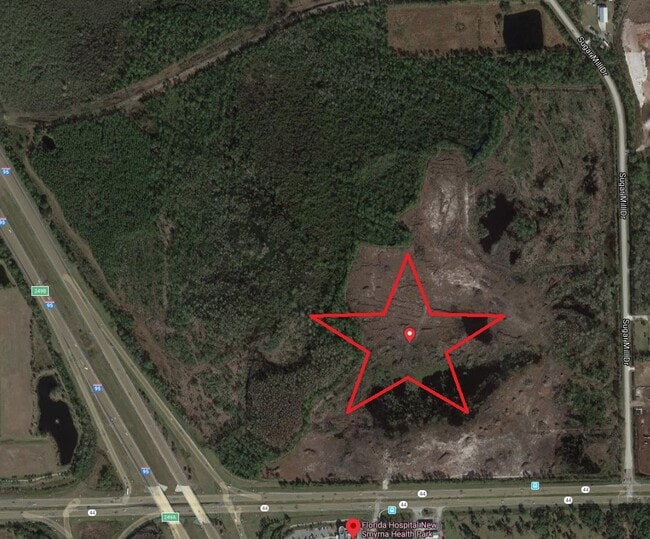
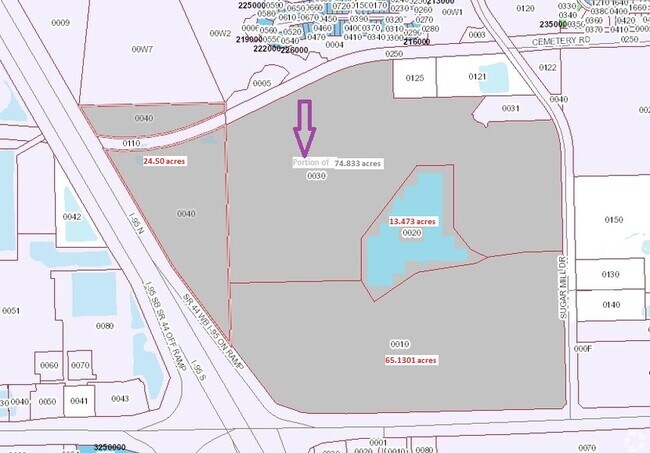
24.50 AC
2025
South Beach Cities
2026
Deltona/Daytona Beach
082903
Deltona-Daytona Beach-Ormond Beach, FL
NEARBY LISTINGS FOR SALE OR LEASE
DEMOGRAPHICS near I 95
1 mile
3 mile
5 mile
2025 Total Population
2,266
16,819
47,128
2030 Population
2,469
18,240
51,052
Pop Growth 2025-2030
+ 8.96%
+ 8.45%
+ 8.33%
Average Age
44
48
48
2025 Total Households
999
7,689
20,881
HH Growth 2025-2030
+ 8.91%
+ 8.34%
+ 8.33%
Median Household Inc
$85,848
$77,345
$74,638
Avg Household Size
2.30
2.10
2.20
2025 Avg HH Vehicles
2.00
2.00
2.00
Median Home Value
$352,654
$388,336
$409,268
Median Year Built
2005
1999
1995
Nearby Places
Map Layers
Map Styles
 Street
 Aerial
Layers
 Traffic
 Biking
Places
Listings with unknown addresses are not visible on the map
- Restaurants
- Banks
- Shops
- Fitness
- Groceries
PUBLIC TRANSPORTATION
AIRPORT
Daytona Beach International
Drive
Walk
Distance
Daytona Beach International
20 min
14.3 mi
Orlando Sanford International
Drive
Walk
Distance
Orlando Sanford International
57 min
42.0 mi
Freight Ports
Port Canaveral
Drive
Walk
Distance
Port Canaveral
81 min
70.6 mi
Nearby Properties
Address
Land Use
TOTAL SIZE
Lot Size
Zoning
Address
Land Use
TOTAL SIZE
Lot Size
Zoning
444,128 SF
6.52 AC
PUD
Address
Land Use
TOTAL SIZE
Lot Size
Zoning
400,946 SF
0.39 AC
Address
Land Use
TOTAL SIZE
Lot Size
Zoning
317,281 SF
21.97 AC
RR
Address
Land Use
TOTAL SIZE
Lot Size
Zoning
260,126 SF
2 AC
10R3
Address
Land Use
TOTAL SIZE
Lot Size
Zoning
150,044 SF
19.80 AC
R4
Address
Land Use
TOTAL SIZE
Lot Size
Zoning
113,944 SF
3.05 AC
Address
Land Use
TOTAL SIZE
Lot Size
Zoning
162,622 SF
20.33 AC
B62
Address
Land Use
TOTAL SIZE
Lot Size
Zoning
7,345 SF
0.43 AC
MH1
Address
Land Use
TOTAL SIZE
Lot Size
Zoning
91,759 SF
10.15 AC
10B2
Address
Land Use
TOTAL SIZE
Lot Size
Zoning
110,926 SF
7.02 AC
Address
Land Use
TOTAL SIZE
Lot Size
Zoning
51,507 SF
10.61 AC
B3C
Address
Land Use
TOTAL SIZE
Lot Size
Zoning
43,852 SF
8.81 AC
RR
Address
Land Use
TOTAL SIZE
Lot Size
Zoning
47,434 SF
11.41 AC
10R3
Address
Land Use
TOTAL SIZE
Lot Size
Zoning
65.13 AC
Address
Land Use
TOTAL SIZE
Lot Size
Zoning
115,028 SF
16.51 AC
R4
Address
Land Use
TOTAL SIZE
Lot Size
Zoning
2,262 SF
222.03 AC
A1
Address
Land Use
TOTAL SIZE
Lot Size
Zoning
32,198 SF
1.88 AC
A3C2
Address
Land Use
TOTAL SIZE
Lot Size
Zoning
53,157 SF
75.97 AC
I2
Address
Land Use
TOTAL SIZE
Lot Size
Zoning
79,518 SF
8.69 AC
B3
Address
Land Use
TOTAL SIZE
Lot Size
Zoning
56,841 SF
8.81 AC
B4C
Address
Land Use
TOTAL SIZE
Lot Size
Zoning
33,031 SF
0.55 AC
10R4
Address
Land Use
TOTAL SIZE
Lot Size
Zoning
60,370 SF
6.20 AC
10B4
Address
Land Use
TOTAL SIZE
Lot Size
Zoning
19,334 SF
2.55 AC
Address
Land Use
TOTAL SIZE
Lot Size
Zoning
38,688 SF
5.39 AC
10R4
Address
Land Use
TOTAL SIZE
Lot Size
Zoning
38,112 SF
0.25 AC
10R4
Address
Land Use
TOTAL SIZE
Lot Size
Zoning
Address
Land Use
TOTAL SIZE
Lot Size
Zoning
245.69 AC
Address
Land Use
TOTAL SIZE
Lot Size
Zoning
49,283 SF
80.41 AC
01R3
Address
Land Use
TOTAL SIZE
Lot Size
Zoning
7,060 SF
2.81 AC
Address
Land Use
TOTAL SIZE
Lot Size
Zoning
960 SF
5.77 AC
B6C2
The World's #1 Commercial Real Estate Marketplace
Connect with us
© 2026 CoStar Group
The information above has been obtained from sources believed reliable. While we do not doubt its accuracy we have not verified it and make no guarantee, warranty or representation about it. It is your responsibility to independently confirm its accuracy and completeness. Any projections, opinions, assumptions, or estimates used are for example only and do not represent the current or future performance of the property. The value of this transaction to you depends on tax and other factors which should be evaluated by your tax, financial, and legal advisors. You and your advisors should conduct a careful, independent investigation of the property to determine to your satisfaction the suitability of the property for your needs.