Property Record
23331 N Interstate 35 N, New Braunfels, TX 78132

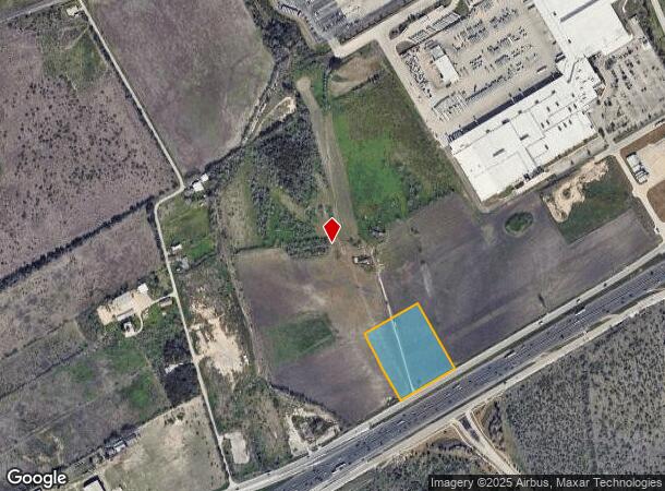
This Property Is For Sale
NEARBY LISTINGS FOR SALE OR LEASE
Property Detail
23331 N Interstate 35 N
San Antonio-New Braunfels, TX
A-685 Sur-257 J F Zepeda
78-0685-0005-00
A-685 SUR-257 J F ZEPEDA, ACRES 5.
Agriculturalland
Comal
X
Texas
48091C0440F
5 AC
2024
Comal County
2025
San Antonio
310804
DEMOGRAPHICS near 23331 N Interstate 35 N
1 Mile
3 Mile
5 Mile
2024 Total Population
2,111
23,508
63,357
2029 Population
2,592
28,026
75,454
Pop Growth 2024-2029
+ 22.79%
+ 19.22%
+ 19.09%
Average Age
37
35
36
2024 Total Households
726
7,502
20,551
HH Growth 2024-2029
+ 22.73%
+ 19.62%
+ 19.49%
Median Household Inc
$109,883
$104,935
$106,760
Avg Household Size
2.90
3.10
3.10
2024 Avg HH Vehicles
2.00
2.00
2.00
Median Home Value
$266,298
$277,087
$274,666
Median Year Built
2010
2010
2007
Nearby Places
Map Layers
Map Styles
 Street
 Aerial
- Restaurants
- Banks
- Shops
- Fitness
- Groceries
PUBLIC TRANSPORTATION
AIRPORT
San Antonio International
DRIVE
WALK
Distance
San Antonio International
25 min
19.1 mi
Freight Ports
Calhoun Port
DRIVE
WALK
Distance
Calhoun Port
180 min
152.6 mi
Nearby Properties
Address
Land Use
TOTAL SIZE
Lot Size
Zoning
Address
Land Use
TOTAL SIZE
Lot Size
Zoning
361,563 SF
53.38 AC
Address
Land Use
TOTAL SIZE
Lot Size
Zoning
151,529 SF
18.40 AC
Address
Land Use
TOTAL SIZE
Lot Size
Zoning
94,020 SF
40.08 AC
Address
Land Use
TOTAL SIZE
Lot Size
Zoning
126,334 SF
30.38 AC
Address
Land Use
TOTAL SIZE
Lot Size
Zoning
103,044 SF
13.50 AC
Address
Land Use
TOTAL SIZE
Lot Size
Zoning
52,898 SF
39.39 AC
Address
Land Use
TOTAL SIZE
Lot Size
Zoning
3,372 SF
76.62 AC
Address
Land Use
TOTAL SIZE
Lot Size
Zoning
110,162 SF
2.67 AC
Address
Land Use
TOTAL SIZE
Lot Size
Zoning
89,104 SF
13.86 AC
Address
Land Use
TOTAL SIZE
Lot Size
Zoning
1,344 SF
59.45 AC
Address
Land Use
TOTAL SIZE
Lot Size
Zoning
2,400 SF
7.48 AC
Address
Land Use
TOTAL SIZE
Lot Size
Zoning
1,308 SF
376.27 AC
Address
Land Use
TOTAL SIZE
Lot Size
Zoning
2,208 SF
20.11 AC
Address
Land Use
TOTAL SIZE
Lot Size
Zoning
58.80 AC
Address
Land Use
TOTAL SIZE
Lot Size
Zoning
Address
Land Use
TOTAL SIZE
Lot Size
Zoning
40,358 SF
3.27 AC
Address
Land Use
TOTAL SIZE
Lot Size
Zoning
28,564 SF
3.28 AC
Address
Land Use
TOTAL SIZE
Lot Size
Zoning
121,451 SF
7.33 AC
Address
Land Use
TOTAL SIZE
Lot Size
Zoning
25.13 AC
Address
Land Use
TOTAL SIZE
Lot Size
Zoning
18,027 SF
1.67 AC
Address
Land Use
TOTAL SIZE
Lot Size
Zoning
36,628 SF
7.77 AC
Address
Land Use
TOTAL SIZE
Lot Size
Zoning
19,675 SF
8.34 AC
Address
Land Use
TOTAL SIZE
Lot Size
Zoning
Address
Land Use
TOTAL SIZE
Lot Size
Zoning
42.98 AC
Address
Land Use
TOTAL SIZE
Lot Size
Zoning
14,073 SF
13.54 AC
Address
Land Use
TOTAL SIZE
Lot Size
Zoning
410.44 AC
Address
Land Use
TOTAL SIZE
Lot Size
Zoning
17,829 SF
2.98 AC
Address
Land Use
TOTAL SIZE
Lot Size
Zoning
16,003 SF
3.21 AC
Address
Land Use
TOTAL SIZE
Lot Size
Zoning
14,942 SF
8.63 AC
Address
Land Use
TOTAL SIZE
Lot Size
Zoning
160,783 SF
7.49 AC
The World's #1 Commercial Real Estate Marketplace
Connect with us
© 2025 CoStar Group
The information above has been obtained from sources believed reliable. While we do not doubt its accuracy we have not verified it and make no guarantee, warranty or representation about it. It is your responsibility to independently confirm its accuracy and completeness. Any projections, opinions, assumptions, or estimates used are for example only and do not represent the current or future performance of the property. The value of this transaction to you depends on tax and other factors which should be evaluated by your tax, financial, and legal advisors. You and your advisors should conduct a careful, independent investigation of the property to determine to your satisfaction the suitability of the property for your needs.