Property Record
Il Route 120, Mchenry, IL
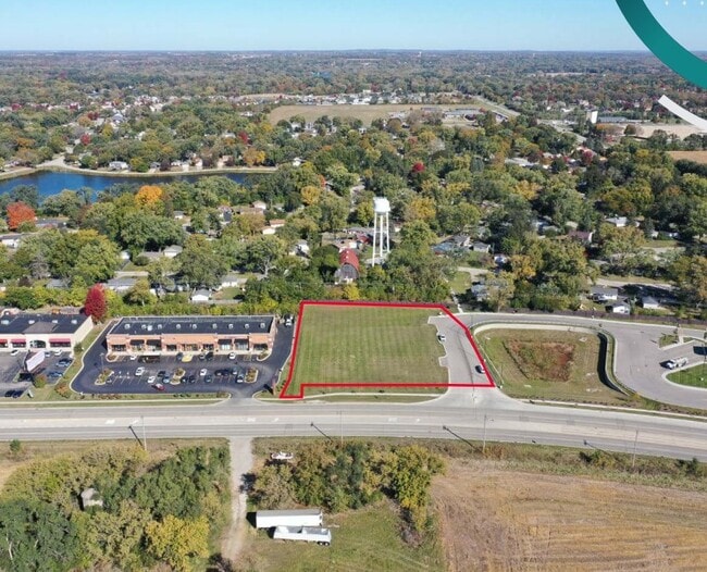
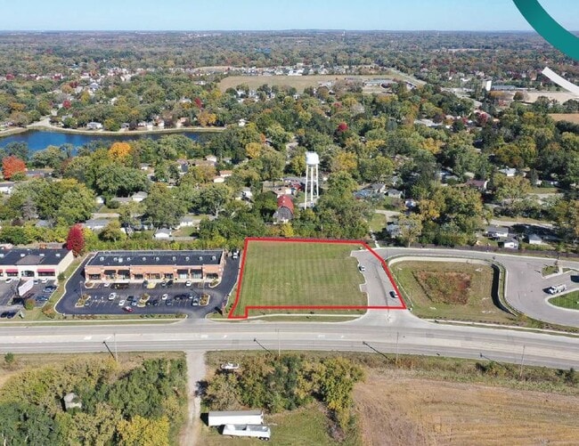
This Property Is For Sale
NEARBY LISTINGS FOR SALE OR LEASE
-
-
-
-
-
SWC Route 31 & Alexander Drive @ Alexander Drive
Johnsburg, IL 60050
Rent Upon Request
16 AC Lots
Land
-
-
-
View all Mchenry listings for sale on LoopNet.com
Property Detail
Il Route 120
Chicago-Naperville-Elgin, IL-IN
Heidner Properties Sub
09-36-226-002
DOC 2018R0000272 (PLAT) S PT LT 1 HEIDNER PROPERTIES SUB
Commercialnec
McHenry
X
Illinois
17111C0230J
1
2024
0.74 AC
2024
Far Northwest
870702
Chicago
DEMOGRAPHICS near Il Route 120
1 Mile
3 Mile
5 Mile
2024 Total Population
3,404
33,891
74,619
2029 Population
3,439
34,097
75,020
Pop Growth 2024-2029
+ 1.03%
+ 0.61%
+ 0.54%
Average Age
42
42
41
2024 Total Households
1,305
13,456
29,309
HH Growth 2024-2029
+ 1.07%
+ 0.59%
+ 0.53%
Median Household Inc
$94,773
$80,499
$83,719
Avg Household Size
2.60
2.50
2.50
2024 Avg HH Vehicles
2.00
2.00
2.00
Median Home Value
$299,208
$227,184
$228,492
Median Year Built
1988
1983
1986
Nearby Places
Map Layers
Map Styles
 Street
 Aerial
- Restaurants
- Banks
- Shops
- Fitness
- Groceries
PUBLIC TRANSPORTATION
COMMUTER RAIL
Mchenry Station (Union Pacific Northwest Line - Northeast Illinois Regional Commuter Railroad (Metra))
DRIVE
WALK
Distance
Mchenry Station (Union Pacific Northwest Line - Northeast Illinois Regional Commuter Railroad (Metra))
5 min
2.0 mi
Fox Lake Station (Milwaukee District North Line - Northeast Illinois Regional Commuter Railroad (Metra))
DRIVE
WALK
Distance
Fox Lake Station (Milwaukee District North Line - Northeast Illinois Regional Commuter Railroad (Metra))
16 min
10.0 mi
Freight Ports
Port Milwaukee
DRIVE
WALK
Distance
Port Milwaukee
82 min
64.6 mi
Nearby Properties
Address
Land Use
TOTAL SIZE
Lot Size
Zoning
Address
Land Use
TOTAL SIZE
Lot Size
Zoning
20.51 AC
Address
Land Use
TOTAL SIZE
Lot Size
Zoning
5,000 SF
30.62 AC
Address
Land Use
TOTAL SIZE
Lot Size
Zoning
12.28 AC
Address
Land Use
TOTAL SIZE
Lot Size
Zoning
10.75 AC
Address
Land Use
TOTAL SIZE
Lot Size
Zoning
376,110 SF
13.46 AC
Address
Land Use
TOTAL SIZE
Lot Size
Zoning
54,986 SF
5.83 AC
Address
Land Use
TOTAL SIZE
Lot Size
Zoning
47,440 SF
3.59 AC
Address
Land Use
TOTAL SIZE
Lot Size
Zoning
191,960 SF
19 AC
Address
Land Use
TOTAL SIZE
Lot Size
Zoning
185,809 SF
21 AC
Address
Land Use
TOTAL SIZE
Lot Size
Zoning
10,082 SF
0.80 AC
Address
Land Use
TOTAL SIZE
Lot Size
Zoning
124,114 SF
6.05 AC
Address
Land Use
TOTAL SIZE
Lot Size
Zoning
0.50 AC
Address
Land Use
TOTAL SIZE
Lot Size
Zoning
21,686 SF
0.90 AC
Address
Land Use
TOTAL SIZE
Lot Size
Zoning
267,134 SF
5.59 AC
Address
Land Use
TOTAL SIZE
Lot Size
Zoning
81,264 SF
0.50 AC
Address
Land Use
TOTAL SIZE
Lot Size
Zoning
3.11 AC
Address
Land Use
TOTAL SIZE
Lot Size
Zoning
20.47 AC
Address
Land Use
TOTAL SIZE
Lot Size
Zoning
115,923 SF
12 AC
Address
Land Use
TOTAL SIZE
Lot Size
Zoning
83,570 SF
3 AC
Address
Land Use
TOTAL SIZE
Lot Size
Zoning
46,824 SF
6.68 AC
Address
Land Use
TOTAL SIZE
Lot Size
Zoning
66,380 SF
5.36 AC
Address
Land Use
TOTAL SIZE
Lot Size
Zoning
64,614 SF
5 AC
Address
Land Use
TOTAL SIZE
Lot Size
Zoning
57,000 SF
0.86 AC
Address
Land Use
TOTAL SIZE
Lot Size
Zoning
1,704 SF
0.25 AC
Address
Land Use
TOTAL SIZE
Lot Size
Zoning
10,432 SF
3 AC
Address
Land Use
TOTAL SIZE
Lot Size
Zoning
2,250 SF
6.59 AC
Address
Land Use
TOTAL SIZE
Lot Size
Zoning
103,822 SF
7.64 AC
Address
Land Use
TOTAL SIZE
Lot Size
Zoning
38,783 SF
10.92 AC
Address
Land Use
TOTAL SIZE
Lot Size
Zoning
75,402 SF
7.34 AC
Address
Land Use
TOTAL SIZE
Lot Size
Zoning
118,020 SF
11 AC
The World's #1 Commercial Real Estate Marketplace
Connect with us
© 2026 CoStar Group
The information above has been obtained from sources believed reliable. While we do not doubt its accuracy we have not verified it and make no guarantee, warranty or representation about it. It is your responsibility to independently confirm its accuracy and completeness. Any projections, opinions, assumptions, or estimates used are for example only and do not represent the current or future performance of the property. The value of this transaction to you depends on tax and other factors which should be evaluated by your tax, financial, and legal advisors. You and your advisors should conduct a careful, independent investigation of the property to determine to your satisfaction the suitability of the property for your needs.