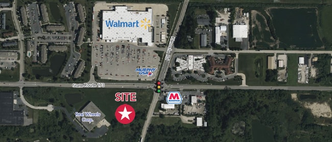
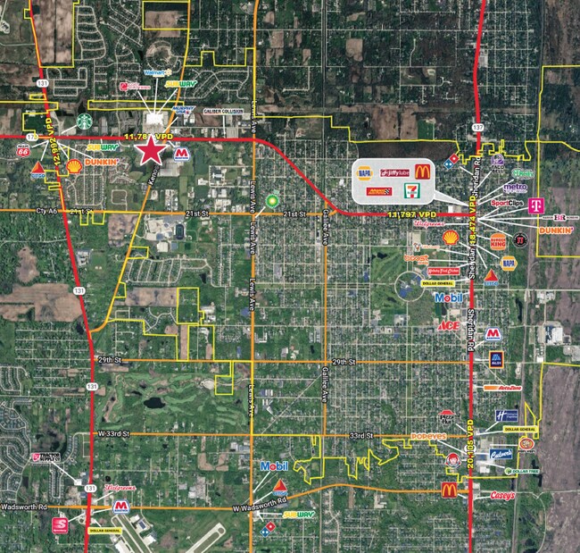
Property Record
Il Route 173, Zion, IL 60099

NEARBY LISTINGS FOR SALE OR LEASE
Property Detail
Il Route 173
Chicago-Naperville-Elgin, IL-IN-WI
PT N1/2 SE1/4;PT LYG WLY OF CLN KENOSHA RD & N OF CLN 21ST S T(EX S 1985 & EX W 826.47 & EXBEG X ELN W 826.47 & SLN IL ROUTE 173 PER DOC 340068,E 340,S 114.36,E 81.43,SE 331.1
04-18-400-049
Lake
Industrialacreage
Illinois
2023
7.08 AC
2024
Far North
860301
Chicago
DEMOGRAPHICS near Il Route 173
1 Mile
3 Mile
5 Mile
2024 Total Population
8,692
41,781
76,789
2029 Population
8,858
42,215
77,366
Pop Growth 2024-2029
+ 1.91%
+ 1.04%
+ 0.75%
Average Age
38
39
39
2024 Total Households
2,989
14,759
27,350
HH Growth 2024-2029
+ 1.87%
+ 0.95%
+ 0.66%
Median Household Inc
$77,172
$77,734
$83,582
Avg Household Size
2.80
2.70
2.70
2024 Avg HH Vehicles
2.00
2.00
2.00
Median Home Value
$227,073
$220,569
$235,810
Median Year Built
1989
1974
1978
Nearby Places
Map Layers
Map Styles
 Street
 Aerial
- Restaurants
- Banks
- Shops
- Fitness
- Groceries
PUBLIC TRANSPORTATION
COMMUTER RAIL
Zion Station (Union Pacific North Line - Northeast Illinois Regional Commuter Railroad (Metra))
DRIVE
WALK
Distance
Zion Station (Union Pacific North Line - Northeast Illinois Regional Commuter Railroad (Metra))
8 min
3.3 mi
Winthrop Harbor Station (Union Pacific North Line - Northeast Illinois Regional Commuter Railroad (Metra))
DRIVE
WALK
Distance
Winthrop Harbor Station (Union Pacific North Line - Northeast Illinois Regional Commuter Railroad (Metra))
9 min
3.8 mi
Freight Ports
Port Milwaukee
DRIVE
WALK
Distance
Port Milwaukee
50 min
43.1 mi
Nearby Properties
Address
Land Use
TOTAL SIZE
Lot Size
Zoning
Address
Land Use
TOTAL SIZE
Lot Size
Zoning
32,000 SF
0.92 AC
Address
Land Use
TOTAL SIZE
Lot Size
Zoning
50.32 AC
Address
Land Use
TOTAL SIZE
Lot Size
Zoning
244,800 SF
23.32 AC
Address
Land Use
TOTAL SIZE
Lot Size
Zoning
215,773 SF
20.50 AC
Address
Land Use
TOTAL SIZE
Lot Size
Zoning
96,384 SF
8.73 AC
Address
Land Use
TOTAL SIZE
Lot Size
Zoning
320,050 SF
0.96 AC
Address
Land Use
TOTAL SIZE
Lot Size
Zoning
150,000 SF
7.93 AC
Address
Land Use
TOTAL SIZE
Lot Size
Zoning
224,750 SF
15.11 AC
Address
Land Use
TOTAL SIZE
Lot Size
Zoning
66,140 SF
0.88 AC
Address
Land Use
TOTAL SIZE
Lot Size
Zoning
0.24 AC
Address
Land Use
TOTAL SIZE
Lot Size
Zoning
33,040 SF
22.81 AC
Address
Land Use
TOTAL SIZE
Lot Size
Zoning
0.36 AC
Address
Land Use
TOTAL SIZE
Lot Size
Zoning
34,476 SF
0.24 AC
Address
Land Use
TOTAL SIZE
Lot Size
Zoning
0.40 AC
Address
Land Use
TOTAL SIZE
Lot Size
Zoning
55,087 SF
0.57 AC
Address
Land Use
TOTAL SIZE
Lot Size
Zoning
85,238 SF
1.14 AC
Address
Land Use
TOTAL SIZE
Lot Size
Zoning
192,376 SF
8.28 AC
Address
Land Use
TOTAL SIZE
Lot Size
Zoning
90,234 SF
5.69 AC
Address
Land Use
TOTAL SIZE
Lot Size
Zoning
0.24 AC
Address
Land Use
TOTAL SIZE
Lot Size
Zoning
65,440 SF
0.16 AC
Address
Land Use
TOTAL SIZE
Lot Size
Zoning
44,900 SF
3.83 AC
Address
Land Use
TOTAL SIZE
Lot Size
Zoning
15.20 AC
Address
Land Use
TOTAL SIZE
Lot Size
Zoning
0.24 AC
Address
Land Use
TOTAL SIZE
Lot Size
Zoning
39.51 AC
Address
Land Use
TOTAL SIZE
Lot Size
Zoning
37,068 SF
1.70 AC
Address
Land Use
TOTAL SIZE
Lot Size
Zoning
59,580 SF
3.33 AC
Address
Land Use
TOTAL SIZE
Lot Size
Zoning
48,134 SF
5.01 AC
Address
Land Use
TOTAL SIZE
Lot Size
Zoning
66,035 SF
0.24 AC
Address
Land Use
TOTAL SIZE
Lot Size
Zoning
60,156 SF
3.45 AC
The World's #1 Commercial Real Estate Marketplace
Connect with us
© 2025 CoStar Group
The information above has been obtained from sources believed reliable. While we do not doubt its accuracy we have not verified it and make no guarantee, warranty or representation about it. It is your responsibility to independently confirm its accuracy and completeness. Any projections, opinions, assumptions, or estimates used are for example only and do not represent the current or future performance of the property. The value of this transaction to you depends on tax and other factors which should be evaluated by your tax, financial, and legal advisors. You and your advisors should conduct a careful, independent investigation of the property to determine to your satisfaction the suitability of the property for your needs.