Property Record
Il Route 31, Richmond, IL 60071
This Property Is For Sale
NEARBY LISTINGS FOR SALE OR LEASE
Property Detail
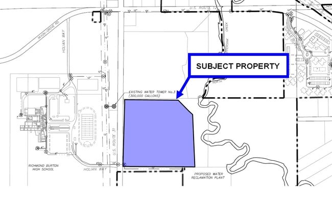
Il Route 31
04-21-400-031
DOC 2021R0030140 PT W1/2 SW1/4 SE1/4
Farms
McHenry
X
Illinois
55127C0500D
19.47 AC
2024
Far Northwest
2024
Chicago
870104
Chicago-Naperville-Elgin, IL-IN-WI
DEMOGRAPHICS near Il Route 31
1 Mile
3 Mile
5 Mile
2024 Total Population
975
5,786
24,418
2029 Population
986
5,917
25,059
Pop Growth 2024-2029
+ 1.13%
+ 2.26%
+ 2.63%
Average Age
43
44
42
2024 Total Households
447
2,362
9,312
HH Growth 2024-2029
+ 1.12%
+ 2.29%
+ 2.65%
Median Household Inc
$72,660
$88,749
$97,478
Avg Household Size
2.20
2.40
2.60
2024 Avg HH Vehicles
2.00
2.00
2.00
Median Home Value
$374,999
$365,782
$318,727
Median Year Built
1996
1994
1991
Nearby Places
Map Layers
Map Styles
 Street
 Aerial
- Restaurants
- Banks
- Shops
- Fitness
- Groceries
PUBLIC TRANSPORTATION
COMMUTER RAIL
Mchenry Station (Union Pacific Northwest Line - Northeast Illinois Regional Commuter Railroad (Metra))
DRIVE
WALK
Distance
Mchenry Station (Union Pacific Northwest Line - Northeast Illinois Regional Commuter Railroad (Metra))
13 min
8.2 mi
Fox Lake Station (Milwaukee District North Line - Northeast Illinois Regional Commuter Railroad (Metra))
DRIVE
WALK
Distance
Fox Lake Station (Milwaukee District North Line - Northeast Illinois Regional Commuter Railroad (Metra))
14 min
8.7 mi
Freight Ports
Port Milwaukee
DRIVE
WALK
Distance
Port Milwaukee
74 min
59.3 mi
Nearby Properties
Address
Land Use
TOTAL SIZE
Lot Size
Zoning
Address
Land Use
TOTAL SIZE
Lot Size
Zoning
327,323 SF
31.01 AC
Address
Land Use
TOTAL SIZE
Lot Size
Zoning
206,452 SF
29.36 AC
Address
Land Use
TOTAL SIZE
Lot Size
Zoning
246,550 SF
10 AC
Address
Land Use
TOTAL SIZE
Lot Size
Zoning
3,000 SF
4.71 AC
Address
Land Use
TOTAL SIZE
Lot Size
Zoning
363,291 SF
43 AC
Address
Land Use
TOTAL SIZE
Lot Size
Zoning
0.90 AC
Address
Land Use
TOTAL SIZE
Lot Size
Zoning
1.48 AC
Address
Land Use
TOTAL SIZE
Lot Size
Zoning
2.83 AC
Address
Land Use
TOTAL SIZE
Lot Size
Zoning
1.23 AC
Address
Land Use
TOTAL SIZE
Lot Size
Zoning
1.12 AC
Address
Land Use
TOTAL SIZE
Lot Size
Zoning
95,760 SF
10.46 AC
Address
Land Use
TOTAL SIZE
Lot Size
Zoning
26,679 SF
5 AC
Address
Land Use
TOTAL SIZE
Lot Size
Zoning
47,606 SF
3.34 AC
Address
Land Use
TOTAL SIZE
Lot Size
Zoning
58,109 SF
2.34 AC
Address
Land Use
TOTAL SIZE
Lot Size
Zoning
31,923 SF
3.77 AC
Address
Land Use
TOTAL SIZE
Lot Size
Zoning
47,250 SF
2.70 AC
Address
Land Use
TOTAL SIZE
Lot Size
Zoning
78,728 SF
8.79 AC
Address
Land Use
TOTAL SIZE
Lot Size
Zoning
13,765 SF
0.65 AC
Address
Land Use
TOTAL SIZE
Lot Size
Zoning
6,161 SF
3.17 AC
Address
Land Use
TOTAL SIZE
Lot Size
Zoning
6.47 AC
Address
Land Use
TOTAL SIZE
Lot Size
Zoning
21,482 SF
1.08 AC
Address
Land Use
TOTAL SIZE
Lot Size
Zoning
4,245 SF
9.57 AC
Address
Land Use
TOTAL SIZE
Lot Size
Zoning
16,202 SF
1.18 AC
Address
Land Use
TOTAL SIZE
Lot Size
Zoning
51,513 SF
4.10 AC
Address
Land Use
TOTAL SIZE
Lot Size
Zoning
35,575 SF
3.34 AC
Address
Land Use
TOTAL SIZE
Lot Size
Zoning
38,434 SF
5 AC
Address
Land Use
TOTAL SIZE
Lot Size
Zoning
20,218 SF
3.59 AC
Address
Land Use
TOTAL SIZE
Lot Size
Zoning
9,985 SF
1.29 AC
Address
Land Use
TOTAL SIZE
Lot Size
Zoning
18,480 SF
2 AC
Address
Land Use
TOTAL SIZE
Lot Size
Zoning
15,300 SF
2 AC
The World's #1 Commercial Real Estate Marketplace
Connect with us
© 2025 CoStar Group
The information above has been obtained from sources believed reliable. While we do not doubt its accuracy we have not verified it and make no guarantee, warranty or representation about it. It is your responsibility to independently confirm its accuracy and completeness. Any projections, opinions, assumptions, or estimates used are for example only and do not represent the current or future performance of the property. The value of this transaction to you depends on tax and other factors which should be evaluated by your tax, financial, and legal advisors. You and your advisors should conduct a careful, independent investigation of the property to determine to your satisfaction the suitability of the property for your needs.