Property Record
Eiler Rd, Belleville, IL 62223
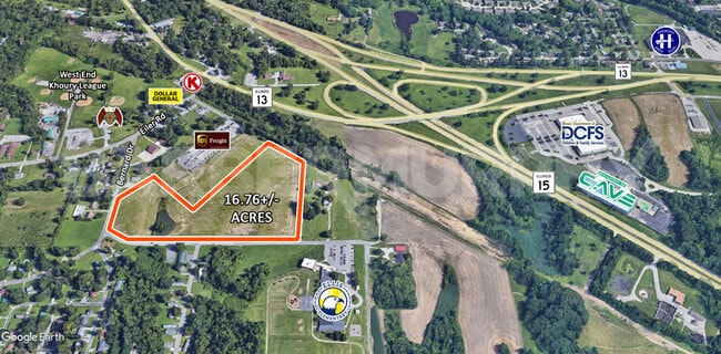

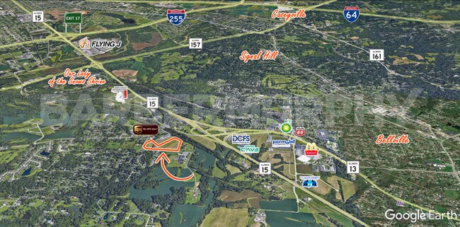
This Property Is For Sale
Property Detail
Eiler Rd
St. Louis
EMGE, RALPH F, TRACTS A. P. PT LT 10 AS IN A02263694 EXC A02601586
St. Louis, MO-IL
ST. CLAIR
07-11-0-303-034
Illinois
Agriculturalland
10
2024
16.76 AC
2024
Illinois
501605
NEARBY LISTINGS FOR SALE OR LEASE
DEMOGRAPHICS near Eiler Rd
1 mile
3 mile
5 mile
2025 Total Population
2,596
22,433
65,409
2030 Population
2,556
21,979
64,408
Pop Growth 2025-2030
(1.54%)
(2.02%)
(1.53%)
Average Age
45
43
42
2025 Total Households
1,139
9,906
27,449
HH Growth 2025-2030
(1.67%)
(2.08%)
(1.60%)
Median Household Inc
$61,591
$57,320
$55,827
Avg Household Size
2.20
2.20
2.30
2025 Avg HH Vehicles
2.00
2.00
2.00
Median Home Value
$203,347
$165,837
$146,127
Median Year Built
1968
1964
1965
Nearby Places
Map Layers
Map Styles
 Street
 Aerial
Layers
 Traffic
 Biking
Places
Listings with unknown addresses are not visible on the map
- Restaurants
- Banks
- Shops
- Fitness
- Groceries
PUBLIC TRANSPORTATION
COMMUTER RAIL
Memorial Hospital (Lambert Airport Shiloh-Scott - St. Louis MetroLink (MetroLink))
Drive
Walk
Distance
Memorial Hospital (Lambert Airport Shiloh-Scott - St. Louis MetroLink (MetroLink))
8 min
4.2 mi
Fairview Heights (Lambert Airport Shiloh-Scott - St. Louis MetroLink (MetroLink), Shrewsbury-Lansdowne I-44 Emerson Park - St. Louis MetroLink (MetroLink))
Drive
Walk
Distance
Fairview Heights (Lambert Airport Shiloh-Scott - St. Louis MetroLink (MetroLink), Shrewsbury-Lansdowne I-44 Emerson Park - St. Louis MetroLink (MetroLink))
13 min
6.9 mi
AIRPORT
Scott AFB/Midamerica St Louis
Drive
Walk
Distance
Scott AFB/Midamerica St Louis
32 min
17.4 mi
St Louis Lambert International
Drive
Walk
Distance
St Louis Lambert International
38 min
24.3 mi
Freight Ports
Port Milwaukee
Drive
Walk
Distance
Port Milwaukee
422 min
371.4 mi
Nearby Properties
Address
Land Use
TOTAL SIZE
Lot Size
Zoning
Address
Land Use
TOTAL SIZE
Lot Size
Zoning
127,590 SF
10.53 AC
Address
Land Use
TOTAL SIZE
Lot Size
Zoning
18,734 SF
10.48 AC
Address
Land Use
TOTAL SIZE
Lot Size
Zoning
104,230 SF
11.08 AC
Address
Land Use
TOTAL SIZE
Lot Size
Zoning
147,888 SF
52.30 AC
Address
Land Use
TOTAL SIZE
Lot Size
Zoning
Address
Land Use
TOTAL SIZE
Lot Size
Zoning
82,500 SF
14.61 AC
Address
Land Use
TOTAL SIZE
Lot Size
Zoning
49,248 SF
2 AC
Address
Land Use
TOTAL SIZE
Lot Size
Zoning
10,505 SF
20.08 AC
Address
Land Use
TOTAL SIZE
Lot Size
Zoning
130,254 SF
11.44 AC
Address
Land Use
TOTAL SIZE
Lot Size
Zoning
13,546 SF
11.19 AC
Address
Land Use
TOTAL SIZE
Lot Size
Zoning
4,420 SF
3.82 AC
Address
Land Use
TOTAL SIZE
Lot Size
Zoning
16,549 SF
5.44 AC
Address
Land Use
TOTAL SIZE
Lot Size
Zoning
54,179 SF
9.26 AC
Address
Land Use
TOTAL SIZE
Lot Size
Zoning
18.43 AC
Address
Land Use
TOTAL SIZE
Lot Size
Zoning
26.26 AC
C2
Address
Land Use
TOTAL SIZE
Lot Size
Zoning
18,837 SF
134.15 AC
Address
Land Use
TOTAL SIZE
Lot Size
Zoning
15,480 SF
1.35 AC
Address
Land Use
TOTAL SIZE
Lot Size
Zoning
4,638 SF
13.10 AC
Address
Land Use
TOTAL SIZE
Lot Size
Zoning
51,739 SF
1.99 AC
Address
Land Use
TOTAL SIZE
Lot Size
Zoning
14,748 SF
1.78 AC
Address
Land Use
TOTAL SIZE
Lot Size
Zoning
6.65 AC
Address
Land Use
TOTAL SIZE
Lot Size
Zoning
68,968 SF
3.55 AC
Address
Land Use
TOTAL SIZE
Lot Size
Zoning
16,637 SF
4.59 AC
Address
Land Use
TOTAL SIZE
Lot Size
Zoning
5,512 SF
10.36 AC
Address
Land Use
TOTAL SIZE
Lot Size
Zoning
102,418 SF
9.70 AC
Address
Land Use
TOTAL SIZE
Lot Size
Zoning
12,950 SF
1.81 AC
Address
Land Use
TOTAL SIZE
Lot Size
Zoning
13,741 SF
0.44 AC
Address
Land Use
TOTAL SIZE
Lot Size
Zoning
19.66 AC
Address
Land Use
TOTAL SIZE
Lot Size
Zoning
3,666 SF
2.86 AC
Address
Land Use
TOTAL SIZE
Lot Size
Zoning
14.70 AC
The World's #1 Commercial Real Estate Marketplace
Connect with us
© 2026 CoStar Group
The information above has been obtained from sources believed reliable. While we do not doubt its accuracy we have not verified it and make no guarantee, warranty or representation about it. It is your responsibility to independently confirm its accuracy and completeness. Any projections, opinions, assumptions, or estimates used are for example only and do not represent the current or future performance of the property. The value of this transaction to you depends on tax and other factors which should be evaluated by your tax, financial, and legal advisors. You and your advisors should conduct a careful, independent investigation of the property to determine to your satisfaction the suitability of the property for your needs.