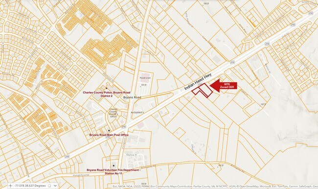
Property Record
Indian Head Hwy, Bryans Road, MD 20616

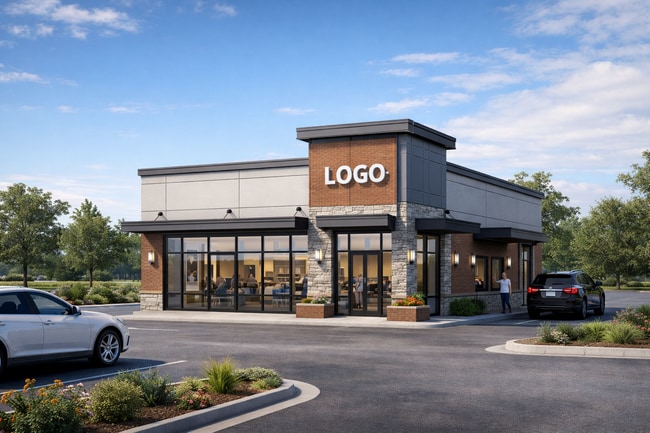
This Property Is For Sale
Property Detail
Indian Head Hwy
07-029985
.5043 AC BRYANS RD
Commercialnec
CHARLES
CER
Maryland
B and X Area of moderate flood hazard, usually the area between the limits of the 100-year and 500-year floods.
1.39 AC
0
Charles County
2025
Washington, DC
850101
Washington-Arlington-Alexandria, DC-VA-MD-WV
NEARBY LISTINGS FOR SALE OR LEASE
DEMOGRAPHICS near Indian Head Hwy
1 mile
3 mile
5 mile
2025 Total Population
4,798
18,262
36,520
2030 Population
5,066
18,958
38,001
Pop Growth 2025-2030
+ 5.59%
+ 3.81%
+ 4.06%
Average Age
38
40
41
2025 Total Households
1,689
6,239
12,399
HH Growth 2025-2030
+ 5.68%
+ 3.94%
+ 4.16%
Median Household Inc
$118,460
$118,215
$123,088
Avg Household Size
2.80
2.90
2.90
2025 Avg HH Vehicles
2.00
2.00
2.00
Median Home Value
$359,294
$398,965
$445,863
Median Year Built
1995
1994
1992
Nearby Places
Map Layers
Map Styles
 Street
 Aerial
Layers
 Traffic
 Biking
Places
Listings with unknown addresses are not visible on the map
- Restaurants
- Banks
- Shops
- Fitness
- Groceries
PUBLIC TRANSPORTATION
AIRPORT
Ronald Reagan Washington Ntl
Drive
Walk
Distance
Ronald Reagan Washington Ntl
39 min
22.3 mi
Freight Ports
Port of Baltimore
Drive
Walk
Distance
Port of Baltimore
85 min
56.3 mi
Nearby Properties
Address
Land Use
TOTAL SIZE
Lot Size
Zoning
Address
Land Use
TOTAL SIZE
Lot Size
Zoning
1,253.29 AC
WCD
Address
Land Use
TOTAL SIZE
Lot Size
Zoning
164,817 SF
37.87 AC
WCD
Address
Land Use
TOTAL SIZE
Lot Size
Zoning
90,543 SF
2.99 AC
CS
Address
Land Use
TOTAL SIZE
Lot Size
Zoning
153.89 AC
WCD
Address
Land Use
TOTAL SIZE
Lot Size
Zoning
12,474 SF
453.08 AC
WCD
Address
Land Use
TOTAL SIZE
Lot Size
Zoning
65,225 SF
6.99 AC
WCD
Address
Land Use
TOTAL SIZE
Lot Size
Zoning
63,752 SF
1.55 AC
CRR
Address
Land Use
TOTAL SIZE
Lot Size
Zoning
54,432 SF
214.83 AC
IG
Address
Land Use
TOTAL SIZE
Lot Size
Zoning
38,543 SF
5.42 AC
CRR
Address
Land Use
TOTAL SIZE
Lot Size
Zoning
40,133 SF
3.30 AC
IE
Address
Land Use
TOTAL SIZE
Lot Size
Zoning
9,660 SF
4.95 AC
CRR
Address
Land Use
TOTAL SIZE
Lot Size
Zoning
15,938 SF
11.77 AC
CER
Address
Land Use
TOTAL SIZE
Lot Size
Zoning
25,971 SF
1.52 AC
CRR
Address
Land Use
TOTAL SIZE
Lot Size
Zoning
43,614 SF
1.23 AC
CRR
Address
Land Use
TOTAL SIZE
Lot Size
Zoning
10,990 SF
1.70 AC
WCD
Address
Land Use
TOTAL SIZE
Lot Size
Zoning
11,002 SF
4.54 AC
WCD
Address
Land Use
TOTAL SIZE
Lot Size
Zoning
576 SF
8.53 AC
PMH
Address
Land Use
TOTAL SIZE
Lot Size
Zoning
26,730 SF
20.04 AC
WCD
Address
Land Use
TOTAL SIZE
Lot Size
Zoning
18,668 SF
2.86 AC
CRR
Address
Land Use
TOTAL SIZE
Lot Size
Zoning
10,872 SF
2.49 AC
WCD
Address
Land Use
TOTAL SIZE
Lot Size
Zoning
23,320 SF
6.32 AC
CER
Address
Land Use
TOTAL SIZE
Lot Size
Zoning
20,000 SF
35.85 AC
WCD
Address
Land Use
TOTAL SIZE
Lot Size
Zoning
15,348 SF
2.08 AC
CC
Address
Land Use
TOTAL SIZE
Lot Size
Zoning
3,604 SF
1.04 AC
CRR
Address
Land Use
TOTAL SIZE
Lot Size
Zoning
9,494 SF
6.11 AC
WCD
Address
Land Use
TOTAL SIZE
Lot Size
Zoning
381.13 AC
WCD
Address
Land Use
TOTAL SIZE
Lot Size
Zoning
1,800 SF
1.44 AC
CRR
Address
Land Use
TOTAL SIZE
Lot Size
Zoning
18,050 SF
1.87 AC
CS
Address
Land Use
TOTAL SIZE
Lot Size
Zoning
34,500 SF
1.36 AC
WCD
Address
Land Use
TOTAL SIZE
Lot Size
Zoning
7.93 AC
CGO
The World's #1 Commercial Real Estate Marketplace
Connect with us
© 2026 CoStar Group
The information above has been obtained from sources believed reliable. While we do not doubt its accuracy we have not verified it and make no guarantee, warranty or representation about it. It is your responsibility to independently confirm its accuracy and completeness. Any projections, opinions, assumptions, or estimates used are for example only and do not represent the current or future performance of the property. The value of this transaction to you depends on tax and other factors which should be evaluated by your tax, financial, and legal advisors. You and your advisors should conduct a careful, independent investigation of the property to determine to your satisfaction the suitability of the property for your needs.