Property Record
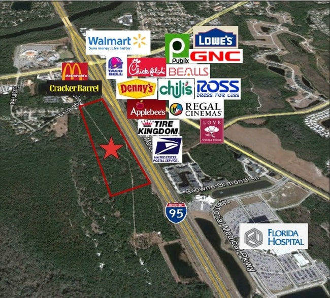
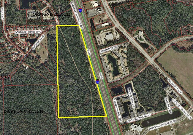
Interchange Blvd, Daytona Beach, FL 32174

Property Detail
Interchange Blvd
4231-00-00-0051
31-14-32 BEGINNING NW CORNER OF SEC 31 THENCE E 517.33 FT THENCE SE 2350.39 FT THENCE W 1133.58 FT THENCE N 2269.15 FT TO POINT OF BEGINNING PER OR 4356 PG 4905 PER OR 5802 PGS 0976-0977
Commercialacreage
VOLUSIA
R2
Florida
A Areas with a 1% annual chance of flooding and a 26% chance of flooding over the life of a 30-year mortgage.
43 AC
2025
North Daytona Beach
2026
Deltona/Daytona Beach
080807
Deltona-Daytona Beach-Ormond Beach, FL
NEARBY LISTINGS FOR SALE OR LEASE
DEMOGRAPHICS near Interchange Blvd
1 mile
3 mile
5 mile
2025 Total Population
3,283
40,018
92,912
2030 Population
3,616
43,658
100,646
Pop Growth 2025-2030
+ 10.14%
+ 9.10%
+ 8.32%
Average Age
46
46
45
2025 Total Households
1,500
17,323
40,095
HH Growth 2025-2030
+ 10.13%
+ 9.22%
+ 8.39%
Median Household Inc
$75,211
$66,573
$58,731
Avg Household Size
2.20
2.20
2.20
2025 Avg HH Vehicles
2.00
2.00
2.00
Median Home Value
$399,999
$355,273
$328,356
Median Year Built
1998
1995
1985
Nearby Places
Map Layers
Map Styles
 Street
 Aerial
Transit
 Traffic
 Biking
Places
Listings with unknown addresses are not visible on the map
- Restaurants
- Banks
- Shops
- Fitness
- Groceries
PUBLIC TRANSPORTATION
AIRPORT
Daytona Beach International
Drive
Walk
Distance
Daytona Beach International
13 min
8.1 mi
Freight Ports
Port Canaveral
Drive
Walk
Distance
Port Canaveral
86 min
75.3 mi
SALE & LEASE HISTORY
LISTING DATE
SALE/LEASE

Sep 24, 2016
For Sale
Nearby Properties
Address
Land Use
TOTAL SIZE
Lot Size
Zoning
Address
Land Use
TOTAL SIZE
Lot Size
Zoning
849,735 SF
140.62 AC
01A2
Address
Land Use
TOTAL SIZE
Lot Size
Zoning
437,897 SF
28.94 AC
Address
Land Use
TOTAL SIZE
Lot Size
Zoning
451,526 SF
17.96 AC
Address
Land Use
TOTAL SIZE
Lot Size
Zoning
293,850 SF
29.38 AC
Address
Land Use
TOTAL SIZE
Lot Size
Zoning
400,964 SF
38.93 AC
Address
Land Use
TOTAL SIZE
Lot Size
Zoning
491,161 SF
31 AC
Address
Land Use
TOTAL SIZE
Lot Size
Zoning
356,386 SF
0.75 AC
Address
Land Use
TOTAL SIZE
Lot Size
Zoning
12,394 SF
139.59 AC
Address
Land Use
TOTAL SIZE
Lot Size
Zoning
135,122 SF
78 AC
Address
Land Use
TOTAL SIZE
Lot Size
Zoning
470,843 SF
1.78 AC
RC
Address
Land Use
TOTAL SIZE
Lot Size
Zoning
10,637 SF
0.15 AC
R2
Address
Land Use
TOTAL SIZE
Lot Size
Zoning
307,322 SF
65.41 AC
Address
Land Use
TOTAL SIZE
Lot Size
Zoning
409,718 SF
12.86 AC
Address
Land Use
TOTAL SIZE
Lot Size
Zoning
434,487 SF
20.54 AC
Address
Land Use
TOTAL SIZE
Lot Size
Zoning
425,548 SF
10.16 AC
Address
Land Use
TOTAL SIZE
Lot Size
Zoning
375,572 SF
0.13 AC
R2
Address
Land Use
TOTAL SIZE
Lot Size
Zoning
422,146 SF
32.67 AC
Address
Land Use
TOTAL SIZE
Lot Size
Zoning
359,180 SF
29.73 AC
01A2
Address
Land Use
TOTAL SIZE
Lot Size
Zoning
417,015 SF
27.55 AC
Address
Land Use
TOTAL SIZE
Lot Size
Zoning
333,708 SF
0.24 AC
01A2
Address
Land Use
TOTAL SIZE
Lot Size
Zoning
259,175 SF
23.45 AC
Address
Land Use
TOTAL SIZE
Lot Size
Zoning
318,707 SF
12.16 AC
Address
Land Use
TOTAL SIZE
Lot Size
Zoning
346,734 SF
14 AC
Address
Land Use
TOTAL SIZE
Lot Size
Zoning
158,299 SF
22 AC
Address
Land Use
TOTAL SIZE
Lot Size
Zoning
180,767 SF
27.05 AC
13R6
Address
Land Use
TOTAL SIZE
Lot Size
Zoning
60,873 SF
8.82 AC
Address
Land Use
TOTAL SIZE
Lot Size
Zoning
184,301 SF
50.28 AC
Address
Land Use
TOTAL SIZE
Lot Size
Zoning
184,829 SF
9.71 AC
01A2
Address
Land Use
TOTAL SIZE
Lot Size
Zoning
56,220 SF
13.13 AC
Address
Land Use
TOTAL SIZE
Lot Size
Zoning
144,660 SF
13.87 AC
The World's #1 Commercial Real Estate Marketplace
Connect with us
© 2026 CoStar Group
The information above has been obtained from sources believed reliable. While we do not doubt its accuracy we have not verified it and make no guarantee, warranty or representation about it. It is your responsibility to independently confirm its accuracy and completeness. Any projections, opinions, assumptions, or estimates used are for example only and do not represent the current or future performance of the property. The value of this transaction to you depends on tax and other factors which should be evaluated by your tax, financial, and legal advisors. You and your advisors should conduct a careful, independent investigation of the property to determine to your satisfaction the suitability of the property for your needs.