Property Record
International St, Doswell, VA 23047
NEARBY LISTINGS FOR SALE OR LEASE
Property Detail
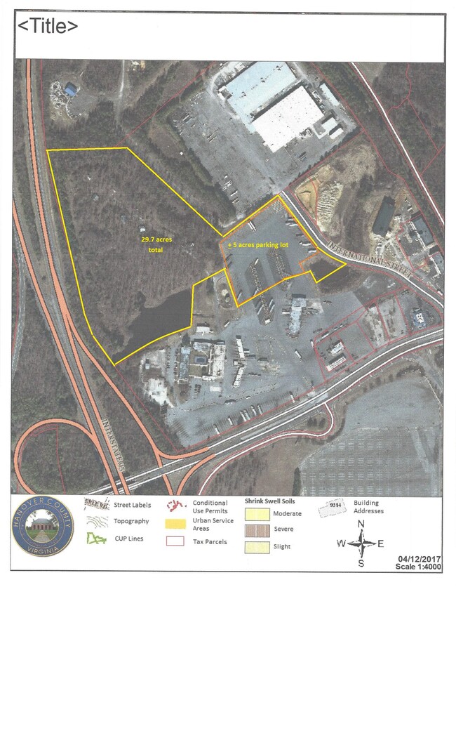
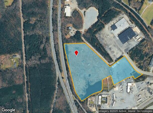
International St
7883-54-5810
N/S RT 30 PCL 2
Commercialnec
Hanover
X
Virginia
51085C0180C
29.79 AC
2025
I-95 North/Chamberlayne
2025
Richmond VA
320100
Richmond, VA
DEMOGRAPHICS near International St
1 Mile
3 Mile
5 Mile
2024 Total Population
164
1,234
5,006
2029 Population
173
1,315
5,385
Pop Growth 2024-2029
+ 5.49%
+ 6.56%
+ 7.57%
Average Age
44
44
42
2024 Total Households
64
476
1,883
HH Growth 2024-2029
+ 6.25%
+ 6.51%
+ 7.70%
Median Household Inc
$71,399
$73,292
$75,559
Avg Household Size
2.50
2.60
2.60
2024 Avg HH Vehicles
3.00
3.00
2.00
Median Home Value
$374,999
$370,422
$306,691
Median Year Built
1982
1985
1988
Nearby Places
Map Layers
Map Styles
 Street
 Aerial
- Restaurants
- Banks
- Shops
- Fitness
- Groceries
PUBLIC TRANSPORTATION
COMMUTER RAIL
Ashland Amtrak (Northeast Regional - Amtrak)
DRIVE
WALK
Distance
Ashland Amtrak (Northeast Regional - Amtrak)
15 min
8.5 mi
AIRPORT
Richmond International
DRIVE
WALK
Distance
Richmond International
43 min
31.4 mi
Freight Ports
Virginia Port Authority - Richmond
DRIVE
WALK
Distance
Virginia Port Authority - Richmond
44 min
31.0 mi
SALE & LEASE HISTORY
LISTING DATE
SALE/LEASE

Jan 05, 2022
For Sale
Nearby Properties
Address
Land Use
TOTAL SIZE
Lot Size
Zoning
Address
Land Use
TOTAL SIZE
Lot Size
Zoning
7,538 SF
600.74 AC
B-3
Address
Land Use
TOTAL SIZE
Lot Size
Zoning
538,610 SF
545.15 AC
M-3
Address
Land Use
TOTAL SIZE
Lot Size
Zoning
2,240 SF
102.06 AC
PRE
Address
Land Use
TOTAL SIZE
Lot Size
Zoning
18.54 AC
A-1
Address
Land Use
TOTAL SIZE
Lot Size
Zoning
244.60 AC
M-2
Address
Land Use
TOTAL SIZE
Lot Size
Zoning
158,936 SF
5.43 AC
M-3
Address
Land Use
TOTAL SIZE
Lot Size
Zoning
45,687 SF
8.66 AC
B-3
Address
Land Use
TOTAL SIZE
Lot Size
Zoning
28.78 AC
M-3
Address
Land Use
TOTAL SIZE
Lot Size
Zoning
11,768 SF
10 AC
PRE
Address
Land Use
TOTAL SIZE
Lot Size
Zoning
35,945 SF
1.41 AC
B-3
Address
Land Use
TOTAL SIZE
Lot Size
Zoning
111.82 AC
M-2
Address
Land Use
TOTAL SIZE
Lot Size
Zoning
2,240 SF
217.60 AC
PRE
Address
Land Use
TOTAL SIZE
Lot Size
Zoning
215,424 SF
30 AC
M-3
Address
Land Use
TOTAL SIZE
Lot Size
Zoning
80,236 SF
25.13 AC
B-3
Address
Land Use
TOTAL SIZE
Lot Size
Zoning
1,202.26 AC
A-1
Address
Land Use
TOTAL SIZE
Lot Size
Zoning
89,280 SF
10.50 AC
B-3
Address
Land Use
TOTAL SIZE
Lot Size
Zoning
698.58 AC
A-1
Address
Land Use
TOTAL SIZE
Lot Size
Zoning
66,438 SF
4.52 AC
M-3
Address
Land Use
TOTAL SIZE
Lot Size
Zoning
38,400 SF
20.60 AC
M-2
Address
Land Use
TOTAL SIZE
Lot Size
Zoning
80,757 SF
23.69 AC
M-3
Address
Land Use
TOTAL SIZE
Lot Size
Zoning
1,308 SF
19.37 AC
M-2
Address
Land Use
TOTAL SIZE
Lot Size
Zoning
26,600 SF
26.41 AC
M-3
Address
Land Use
TOTAL SIZE
Lot Size
Zoning
0.80 AC
A-1
Address
Land Use
TOTAL SIZE
Lot Size
Zoning
315.88 AC
A-1
Address
Land Use
TOTAL SIZE
Lot Size
Zoning
26,927 SF
41.53 AC
M-3
Address
Land Use
TOTAL SIZE
Lot Size
Zoning
22,977 SF
1.34 AC
B-3
Address
Land Use
TOTAL SIZE
Lot Size
Zoning
484 AC
RP
Address
Land Use
TOTAL SIZE
Lot Size
Zoning
442.40 AC
A-1
Address
Land Use
TOTAL SIZE
Lot Size
Zoning
14,859 SF
5.50 AC
M-3
The World's #1 Commercial Real Estate Marketplace
Connect with us
© 2025 CoStar Group
The information above has been obtained from sources believed reliable. While we do not doubt its accuracy we have not verified it and make no guarantee, warranty or representation about it. It is your responsibility to independently confirm its accuracy and completeness. Any projections, opinions, assumptions, or estimates used are for example only and do not represent the current or future performance of the property. The value of this transaction to you depends on tax and other factors which should be evaluated by your tax, financial, and legal advisors. You and your advisors should conduct a careful, independent investigation of the property to determine to your satisfaction the suitability of the property for your needs.